
Set to open in 2023, the Judkins Park light rail station will connect thousands of Seattleites to the growing Link light rail network. The future station, which connects directly to the I-90 trail, is uniquely situated to offer safe transit access to pedestrians, cyclists and users of other modes of transportation, like motorized wheelchairs.
But the Judkins Park light rail station’s connectivity to the I-90 trail only reveals part of the story. The station also abuts Rainier Avenue, a thoroughfare whose high number of collisions and fatalities have earned it the title of Seattle’s “crashiest street.”
A short video produced by Disability Rights Washington (DRW) showcases the current dismal situation for cyclists and pedestrians on a stretch of Rainier Avenue flanked by narrow sidewalks interrupted by street lamp posts. But as the video’s narration points out, the most pressing dangers are presented by the I-90 freeway entrance and exit ramps.
In the video, Anna Zivarts, Director of the Disability Mobility Initiative at DRW, bikes slowly along Rainier Avenue, pointing out areas of special concern and highlighting the dangers for people with disabilities. It is clear that the combination of high speed traffic and limited visibility make the freeway ramp crossings particularly perilous.
The Seattle Department of Transportation (SDOT) and Sound Transit have acknowledged the accessibility issues that face the future Judkins Park Station. In fact, the agencies participated in a 2019 access study that won a Puget Sound Regional Council (PSRC) Vision 2040 award. Undertaken by consultants from local firms Makers and Fehr & Peers, as well as a stakeholder group convened by the Lighthouse for the Blind, the Judkins Park Station Access Study carefully analyzed the surrounding urban landscape, offering up recommendations for improvements. Some of these include “quick wins,” like activating the area under the freeway underpass and installing accessible pedestrian signals (APS) at intersections. The installation of APS is particularly important since clients and employees of the Lighthouse for the Blind are regular commuters through the area.
DRW has engaged with Sound Transit and SDOT around addressing safety concerns at the future Judkins Park Station since 2019, and some short-term improvements have already been made or planned. These include narrower traffic lanes, a bus shelter, rumble strips, crosswalks, new signage, and flex posts. But the organization is continuing to advocate for longer-term improvements, including the addition of a stoplight to allow blind and deaf-blind people to cross Rainier Avenue with greater safety.
I-90 freeway ramps create dangerous conditions
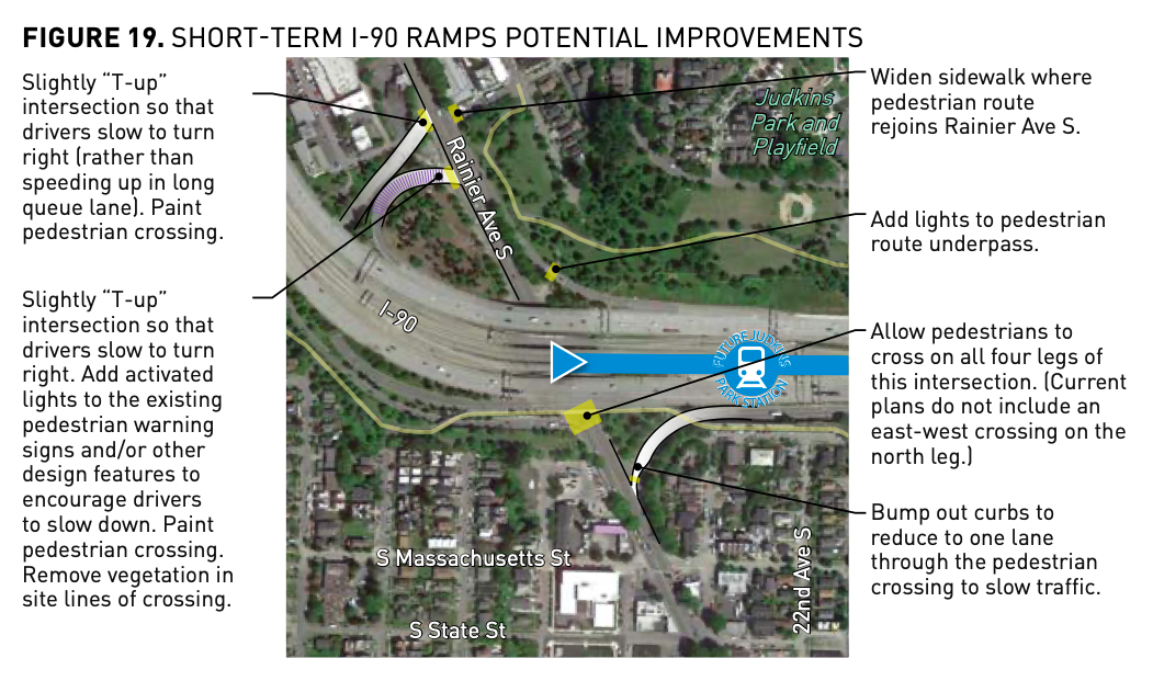
However, even if improvements are made to Rainier Avenue, the presence of the I-90 freeway ramps will continue to present safety concerns. In response to this problem, the station access report offers up recommendations that would decrease traffic speeds and increase pedestrian visibility.
One short-term recommendation is to “T” up the ramps that connect to Rainier Avenue. The visual shown below illustrates what the modification, along with other improvements like bumping out curbs and allowing pedestrians to cross on all four legs of the intersection, might look like.
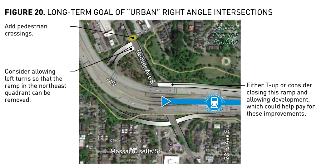
The report also presents the long-term goal of creating an urban or right-angle intersection. Achieving this would require more substantial changes to the freeway ramps infrastructure, including possible ramp reductions and/or closures. While a ramp closure would open up land for development, possibly offsetting some of the cost, creating an urban intersection would still be very expensive. Unofficial estimates have placed the cost of changes to the existing freeway ramps at around $100 million.
Should freeway ramps be in Rainier Avenue’s future?
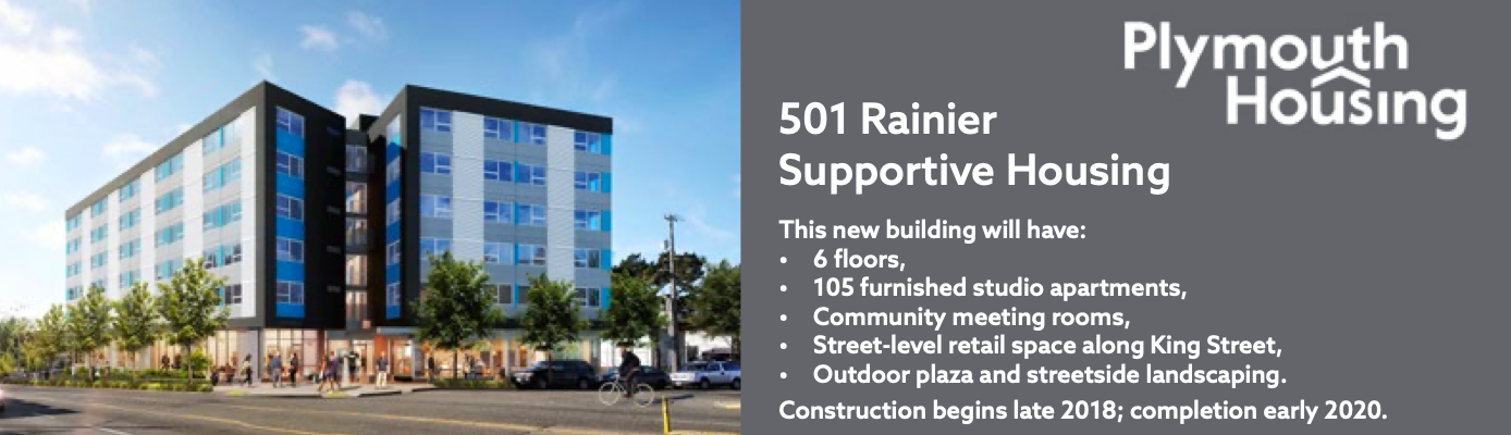
Whether you walk, roll, bike, bus, or drive down this stretch of Rainier Avenue, it is hard to miss the transformation occurring. Once primarily the site of light industrial businesses and parking lots, new residential and commercial development abounds on Rainier. In recent years, both market-rate and affordable housing have sprung up within walking distance of the future light rail station, and more development is in the works–and it’s a similar story near most East Link stations. For example, a land use application for an eight-story, 154-unit mixed-use building with ground level retail, has been made for a parcel at the corner of Rainier Avenue and 21st Street, just a stone’s throw from the future station. The development is planned to include only 64 parking spaces, a revealing detail about what the future holds for the surrounding the neighborhood.
In addition to new housing, established local businesses, like Standard Brewing and Big John’s Pacific Imports Grocery, have opened up new retail locations on the strip. Unlike previous developments that included large surface parking lots, these new developments also have been designed primarily for access by pedestrians.
Given the high cost of changing the existing I-90 freeway ramps, Zivarts has begun to question if the best solution might be to remove the ramps entirely. “Removing all the freeway traffic from Rainier would really transform what is currently one of the most unhealthy and crash prone streets in Seattle,” Zivarts said. “Just looking at all the new housing that’s getting built currently along the stretch of Rainier near the freeway really makes me think it’s time for the city to rethink Rainier and what purpose it serves.”
At the same time, removal of the I-90 freeway ramps might make it more difficult for drivers of both passenger vehicles and freight to access the Central Area of Seattle. The station access report acknowledges that a feasibility study will need to be undertaken before any plans to remove freeway ramps can be put into gear.
In the meantime, SDOT has continued to be engaged in making safety improvements to Rainier Avenue as part of its Vision Zero plan. The improvements are intended to make the street safer for pedestrians and cyclists, while also creating more dedicated bus lanes to increase the reliability of transit through the corridor.

Natalie Bicknell Argerious (she/her) is a reporter and podcast host at The Urbanist. She previously served as managing editor. A passionate urban explorer since childhood, she loves learning how to make cities more inclusive, vibrant, and environmentally resilient. You can often find her wandering around Seattle's Central District and Capitol Hill with her dogs and cat. Email her at natalie [at] theurbanist [dot] org.