On Monday, the Seattle City Council approved a new Parks Development Plan and a list of proposals to be further evaluated as part of the 2018 annual docket to the Comprehensive Plan. The Parks Development Plan, which guides capital investments in recreation and open space facilities over the next six years, received substantial changes over the previous plan in 2011. Seattle Parks and Recreation (SPR) is changing the paradigm for level of service for parks and open space by departing from the metrics of old. Meanwhile, a long list of proposals to amend the Comprehensive Plan will be vetted by the Office of Planning and Community Development before further consideration by the City Council next spring.
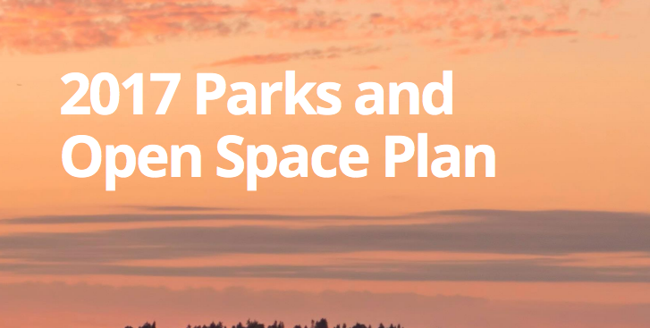
Park Development Plan
The Parks Development Plan (officially called the “2017 Parks and Open Space Plan”) is a city-wide plan that guide investments in recreation and open space facilities through 2022 and forms an element of the city’s Comprehensive Plan. The plan was separated out from the Seattle 2035 process, giving additional time for the plan to be developed.
The plan identifies some 263 different priority improvement, expansion, maintenance, replacement, renovation, and debt service projects for parks over the next six years (estimated at over $350 million) that are pending approval. Another bucket of projects are identified as programmed capital facility improvements over the same period (e.g., expansion of the Seattle Aquarium, synthetic turfing at playfields, and trail renovation). And a handful of discretionary projects totaling more than $127 million remain unfunded, including linear street parks (e.g., Bell Street extension and Ballard Avenue), new sports courts (one each of the city’s four quadrants), and off-leash dog parks (two in each of the city’s four quadrants).
The following is a snippet of key changes from the plan, which Seattle Parks and Recreation highlighted in a report from last month:
| Service Type | 2011 Plan | 2017 Plan | Rationale |
|---|---|---|---|
| Open Space | 3.33 Acres/1,000 Residents | 8 Acres/1,000 Residents | In developing the proposed Citywide Level of Service (LOS), we looked at population growth projections, the price of land, and the availability of property. With an 8 acres/1,000 residents LOS, would need to acquire 40 acres of additional parkland by 2035, or approximately 13.5 acres during each 6-year cycle, assuming that growth projections are on target. If growth projections go up, then the amount of additional parkland needed would increase. |
| Community Centers | A community center should be located within 1- 1.5 miles of every Seattle household and/or 1 full service center to serve a residential population of 15,000-20,000 people. Each urban center of the city is to be served by a center. Satellite facilities, or less then full service facilities, will be considered to provide for community gathering places and to accommodate certain program activities, where conditions warrant. In order to control the number of new city facilities, programs may be provided in facilities owned by others in some cases. | Every household in Seattle should be within 1-2 miles of a Community Center. | The desire is to expand capacity and allow for a broader reach of the population with our existing facilities. The revised guideline allows SPR to be able to implement a programmatic approach to service delivery that creates a draw, and that meets the needs of the community. Taking a strategic, cost effective approach to make better use of our existing facilities, rather than building new facilities. By increasing the service distribution by 0.5 miles, SPR has virtually eliminated service gaps citywide. |
| Greenways | N/A | Continue to coordinate with SDOT on preferred routes and connections to enhance access to parks and open space. | This is a new target goal based upon the Park District Investment Initiative, encouraging links between parks. |
| Sports/Athletic Fields | A soccer field and a turf softball/youth baseball field, is desirable within 1-2 miles of all Seattle households. A sufficient quantity of fields would be provided on a citywide basis to meet scheduling needs. Most (soccer) fields will be natural turf, but a selected number of fields shall be maintained as all-weather surfaces to accommodate intensive levels of play. A turf football field is desirable within areas with youth football programs. A sufficient quantity of fields should be provided on a citywide to meet scheduling needs (and as coordinated with Seattle School District and other program providers). A limited number of turf senior baseball fields are desirable citywide with sufficient quantity to meet scheduling needs. | Every household in Seattle should have access to sports fields within 2 miles. | SPR is focusing on increasing capacity for a variety of uses on existing sports/athletic fields due to the high demand – adult and youth baseball, adult and youth soccer, youth football and lacrosse. |
| Picnic Shelters | At least 1 or 2 scheduled group picnic shelters are desirable in each sector with drop-in picnic tables distributed in appropriate park areas throughout the city. | All reservable picnic shelters should be ADA accessible. | This is a new target goal that focuses on ADA accessibility and allows us to provide for a broad spectrum of users. |
In developing the new level of service standards, SPR conducted a gap analysis to look at how accessible existing recreation facilities are to area residents using a variety of different inputs, such as walkability, equity, and density. This process was highly informative in where new services may be necessary.
2018 Comprehensive Plan Docket
On Monday, the Seattle City Council adopted a slate of topics to be analyzed as part of annual updates to the Comprehensive Plan. More than a dozen different amendments were proposed by the general public (see CF 320265), including proposals to discourage aerial trams, shrink urban villages and protect areas zoned single-family residential, and reduce spillover impacts of parking. Other major proposals were already previously identified, such as expansion of urban villages to implement the Mandatory Housing Affordability program and adopting amendments related to industrial lands. The City Council also requested that amendments be prepared to implement impact mitigation fees for new development.
General Private Proposals
Two proposals by the City Neighborhood Council would amend Land Use policies in the Comprehensive to address parking and concurrency of new public facilities to serve new development. The parking policies seek to reduce spillover parking into neighborhoods beyond urban villages and urban centers (see pages 305 through 310 of CF 320265). Proposed policies include amending Land Use Goal 6 and creating two new policies:
LU G6 Regulate off-street parking to address parking demand in ways that reduce reliance on automobiles, improve public health and safety, reduce greenhouse gas emissions, lower construction costs, create attractive and walkable environments, and promote economic development throughout the city.
These goals and policies would direct the City to create new regulations that effectuate their intent.
Another proposal by the City Neighborhood Council would add a definition to the Comprehensive Plan defining what “concurrency” means (see pages 311 through 316 of CF 320265). One definition that City Neighborhood Council suggested the use of a definition under the Washington Administrative Code (WAC 365-196-210), which defines “concurrency” as when “adequate public facilities are available when the impacts of development occur, or within a specified time thereafter.”
A third proposal submitted by the City Neighborhood Council, Wallingford Chamber of Commerce, and Wallingford Community Council would further amend Land Use Goal 6 (see above) by replacing the phrase “lower construction costs” with “increase affordable housing” as it relates to regulating off-street parking (see pages 317 through 322 of CF 320265).
Mandatory Housing Affordability Amendments
The City Council has signaled a desire to consider amendments that would facilitate implementation of the Mandatory Housing Affordability (MHA) program, including adjustments to policy and the Future Land Use Map (FLUM). The biggest changes would involve expanding urban villages and eliminating references to the preservation of single-family areas if they conflict with implementation of MHA.
This slideshow requires JavaScript.
As part of the MHA review, a few parallel private proposals would be considered alongside the review could result in changes to urban village boundaries or revise local Neighborhood Plans. These include:
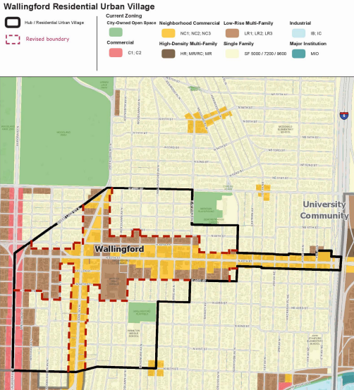
- A proposal by the Wallingford Community Council to remove properties zoned single-family residential from the urban village in Wallingford (see pages 1 through 6 of CF 320265).
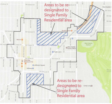
- A proposal by residents in West Seattle Junction neighborhood to amend the neighborhood plan policies by emphasizing preservation of single-family zoning within the neighborhood urban village (see pages 7 through 19 of CF 320265).
- A proposal by residents in the Morgan Junction neighborhood to amend the neighborhood plan policies by emphasizing preservation of single-family zoning within the neighborhood urban village (see pages 296 through 298 of CF 320265).
Additionally, a variety of proposals would make changes to the Land Use Element, including:
- A proposal by Gregory Hill that would establish a new policy to provide more affordable family housing designed for larger families, including those with children and extended family. The policy would encourage the development of larger multi-family units in low density multi-family areas (see pages 360 through 365 of CF 320265); and
- Three separate proposals by Chris Leman focused on land use topics. The first that would revise three related Land Use policies for multifamily residential areas by requiring trees and yards and promoting urban wildlife (see pages 376 through 379 of CF 320265). The second would add a new policy to the Land Use Element that discourages the demolition of houses and displacement of residents (see pages 385 through 388 of CF 320265). The third and last proposal would add two new policies to the Land Use Element would establish new guidance, criteria, and procedures for rezoning (see pages 389 through 392 of CF 320265).
Industrial Lands
Industrial lands have been a recurring topic, particularly as they relate to the Comprehensive Plan. Temporary policies were adopted for Seattle 2035 while the City Council waited on a comprehensive analysis and set of recommendations on how to manage industrial lands in the years ahead. The Mayor commissioned a full study and advisory panel to deliver recommendations last year, which have yet to be delivered. As part of last year’s docket, the City Council specific sought to focus on the Ballard-Interbay-Northend Manufacturing Industrial Center (BINMIC). This year, the City Council has once again expressed an interest in this analysis but with the addition of the Stadium District (essentially reviving earlier work from a few years earlier) and other specific proposals by private individuals:
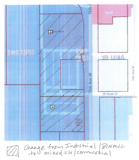
- Two private proposals to amend the Future Land Use Map in the BINMIC. One proposal seeks to remove the Interbay Armory property and designate it as Commercial/Mixed-Use (see page 323 through 330 of CF 320265). Another proposal seeks to remove property located at 1819-1893 15th Ave W and 1855-2033 15th Ave W and designate them as Mixed Use/Commercial (see pages 350 through 358 of CF 320265).
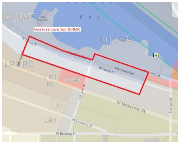
- A proposal by Seattle Pacific University to adjust the boundaries of the BINMIC and revise policies and the City code that allow for expansion of the Major Institution use onto industrial land outside of the BINMIC and south of the Ship Canal (see pages 414 through 420 of CF 320265).
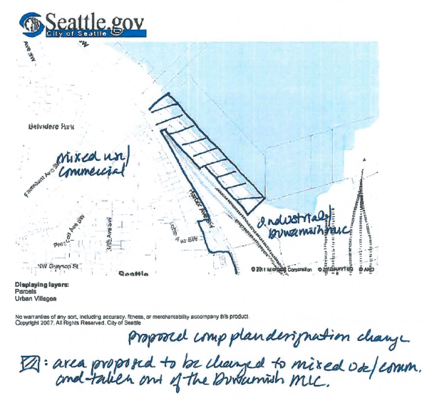
- A private proposal to amend the Future Land Use Map in the Greater Duwamish Manufacturing/Industrial Center. The proposal seeks to remove Pier One in West Seattle from Manufacturing/Industrial Center and redesignate it as Commercial/Mixed-Use (see pages 366 through 374 of CF 320265).
Impact Fees
The City Council has requested that the Office of Planning and Community Development carry out review of impact fees:
The Council requests that the Executive forward any amendments necessary to support implementation of an impact fee program for: public streets, roads, and other transportation improvements; publicly owned parks, open space, and recreation facilities; and school facilities. This may include amendments to update or replace level-of-service standards or to add impact fee project lists in the Capital Facilities Element and amendments to other elements or maps in the Plan, as appropriate.
The proposal is not surprising given that it has been an ongoing policy initiative of the City for some time now and recently received the the full backing of Councilmembers Lisa Herbold, Sally Bagshaw, and Mike O’Brien in an op-ed to The Seattle Times. Under state law, impact fees may be imposed on new development for new capital facilities, such as parks and open space, roads, schools, and fire protection facilities.
Rejected Proposals
Some docket proposals, however, were rejected by the City Council. These included:
- A private proposal to add a new policy to the Growth Strategy Element requiring the City to monitor rate of growth compared to anticipated growth in urban villages. The policy also included specific procedures to respond to encourage and discourage growth through zoning and development standards changes or impact mitigation and incentives (see page 381 of CF 320265); and
- Three proposals by Chris Leman that sought to add a new citywide transportation policy to discourage pedestrian skybridges, tunnels, and aerial trams in urban centers and urban villages. (see pages 393 through 396 of CF 320265), add a new transportation policy to limit damage to streets by heavy vehicles, such as heavy buses purportedly operated by schools and local transit agencies (see pages 397 through 403 of CF 320265), and create a new Element of the Comprehensive Plan focused on “Open and Participatory Government,” which listed specific roles and responsibilities of the Mayor and executive branch of City government, City Council, Seattle Channel, City Hearing Examiner, and other City bodies (see pages 405 through 415 of CF 320265).