My initial Central Tacoma Link Extension (CTLE) surface alignment proposal stirred a large debate regarding how Link light rail should properly serve Tacoma over a decade from now. Among commentators, there was broad agreement that terminating light rail service at Tacoma Dome Station was deeply unsatisfactory, with most agreeing that light rail should reach Downtown Tacoma. Sound Transit is aiming to open the Tacoma Dome Link Extension in 2032.
However, there were also legitimate concerns voiced about how to accomplish getting light rail into Downtown Tacoma. Where the surface CTLE came under routine fire was on two fronts: its interaction with the existing streetcar system, and the location of the Central Tacoma Station. Although these points are discussed in the proposal, they are real concerns that warrant further investigation. The CTLE surface option remains the cheapest and most cost effective manner of delivering trains into Central Tacoma. That station, even without extensive bus connections, has independent utility as a rail station in an urban core.
Still, it is worthy to consider alternative alignments into Tacoma that: one, have no impacts on the existing streetcar system; two, more finely integrate Link with the existing Downtown transit corridor along Commerce Street; and three, further the conversation of getting trains into the city center.
A preliminary review of alternative alignments into Downtown Tacoma produced three distinct alignments, whose components could be mixed to produce a larger variety of routing options. The first option is the original surface alignment. The three new alignments include moderate tunneling or elevated segments. It’s worth noting that the impacted areas are predominantly surface parking lots, a wide avenue, or the margins of a freeway, all of which should dramatically reduce construction costs relative to other large rail projects through a developed urban quarter. All three proposed light rail alignments can be viewed on an interactive ArcGIS map. This article will also assess the alignments’ strengths and weaknesses, as well as make the cost-benefit argument for investing in light rail for Downtown Tacoma rather than an extension to the Tacoma Mall.
Tunnel alignment alternatives
Pacific Avenue is a wide thoroughfare and should be a prime candidate for shallow cut-and-cover tunneling. This manner of tunneling is disruptive, but only a small segment of tunneling is required for the project, which would mitigate its worst impacts. Additionally, such tunneling is substantially less expensive than deep bore tunneling and quicker to construct (with the surface impacted for a one to two-year period). Disruption to surface streets could be reduced with the minimization of trench width and via the use of the Milan method of cut-and-cover tunneling.
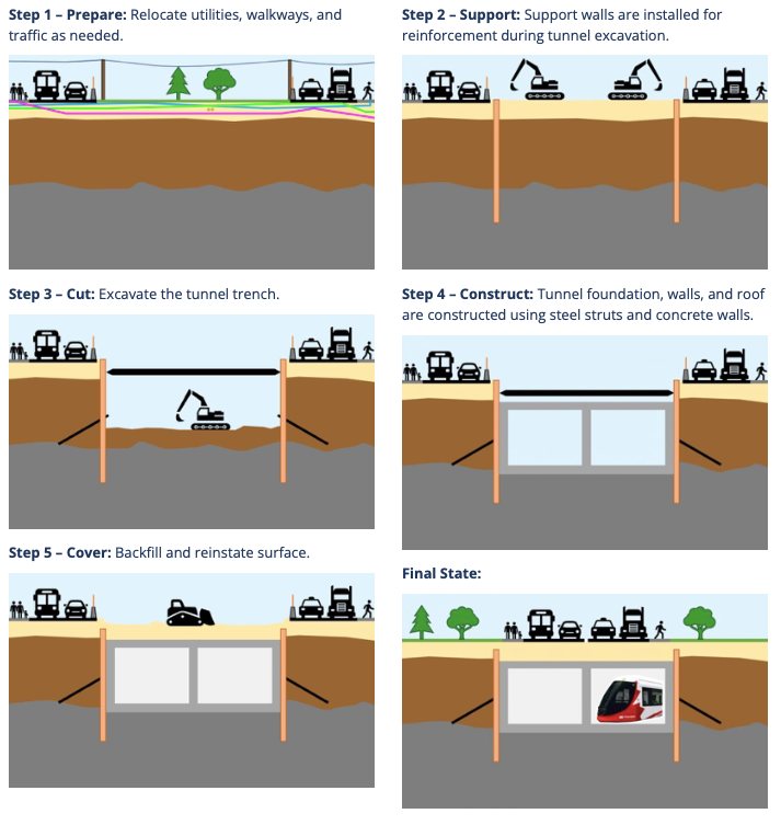
As far as tunneling in an urban area goes, it could not be more straightforward than the options presented within the ArcGIS review map. A deep bore tunnel is simply not required. With a thorough survey of underground utilities, the trenching and utility relocation could be done swiftly and inexpensively compared to similar projects in more densely developed cities. Tacoma is “fortunate” in that regard; it long ago demolished the neighborhoods in the right-of-way under the guise of urban renewal. Of course, a deep bore tunnel should remain on the table if it is determined that their method of construction could deliver a better product for the city, but they would likely represent major scope creep for the project. Here’s an overview of a few different ways a tunnel alternative could be combined with other options.
- A surface and tunneling hybrid. This proposal preserves the Union Station-area track sharing arrangement of the CTLE surface alignment. However, just north of South 17th Street, the trains are sent straight into a shallow tunnel under Pacific Avenue. With only the wide avenue above, the construction method favors cut-and-cover tunneling.
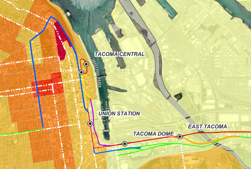
- An elevated and tunneling hybrid. This proposal abandons in its entirety the alignment of the surface CTLE and has no track sharing with the existing streetcar system. Instead, an easterly and largely elevated alignment hugs the west side of I-705, curving around freeway facilities both horizontally and vertically, to provide a new approach into Downtown. Union Station and University of Washington Tacoma would be served by a new side-platform rail station to the east of the History Museum, requiring a rebuild of the Bridge of Glass that fully integrates into the platform system. At 109 South 15th Street, presently a lone building surrounded by a sunken surface parking lot, the track would eventually rest underneath future development as it begins a shallow tunnel alignment that curves toward Pacific Avenue. With only surface parking lots and a wide avenue above, the construction method again favors cut-and-cover tunneling.
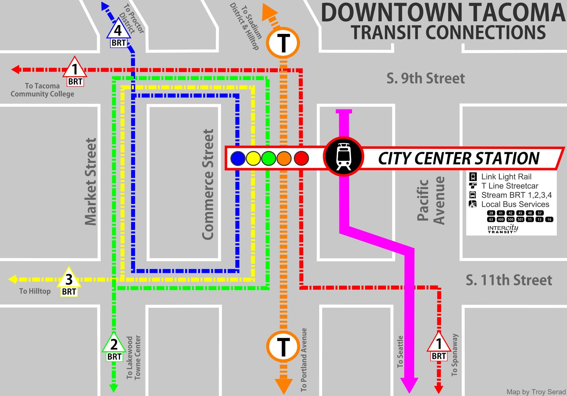
- Pacific Avenue stations. Directly under Pacific Avenue, a new station could be constructed just south of the intersection of 9th and Pacific; or, preferably, trains could be diverted westerly into the large property now hosting the multi-story parking garage owned by Commencement Plaza, LLC, at 923 Commerce Street. This property would be purchased by Sound Transit and would accommodate a seamless Link/bus transfer facility, along with affordable and market-rate housing and commercial businesses. The City Center Station would be a game-changer for the City of Tacoma and the regional transit system.
In sum, the elevated and tunneling hybrid alignment, along with a City Center Station under 923 Commerce Street, appears to be the preferred alternative alignment to the surface option (and it is represented by the diagram accompanying this post). In fact, the merits of such a system are so pronounced that they may render the cheaper surface proposal a penny-wise and pound-foolish option for serving Central Tacoma and knitting together the regional transportation system.
Elevated alignment alternative
An elevated extension to Downtown is another alternative, but I removed it from consideration as being too complex, too visually obstructive, and for making only marginal improvements to local transit system integration over the proposed Central Tacoma Station of the surface alignment.
- A largely elevated alignment. This proposal shares the same elevated infrastructure as described by the elevated and tunnel hybrid alignment. However, near the I-705 ramps at East 15th Street, both an at-grade and elevated approach to access A Street may require presently unknown impacts to the ramps. Any significant impact would necessitate complicated engagement with the State and the federal government to get approvals. Once on the A Street viaduct, trains would either terminate on A Street somewhere between East 10th and 12th Streets, or the trains could swing sharply via a reverse curve on 12th Street into the alley. There, a station could be sited at 110 South 10th Street. This building, now a multi-story parking garage, would be replaced by an elevated station facility along with affordable and market-rate housing.
A closer look at costs
A rudimentary evaluation of the costs for any of these CTLE alternative alignments should be compared against the $1.1 billion dollar Tacoma Mall extension (in 2015-dollars) that would presumably be completed under an Sound Transit 4 program. For this cursory review, the Elevated and Tunnel Hybrid alignment detailed above, with a terminal station within the bounds of 923 Commerce Street, emerges as the preferred alternative to the original surface proposal — which it deserves to be considering the merits.
As is expected, even with tunneling segments, this CTLE extension is far less expensive than a suburban mall extension. There would also be the added benefit of centralizing the regional transit system in Downtown, with all the positive qualities such an urban core hub would entail.
Holding Federal Way Link Extension costs per mile for largely elevated rail infrastructure, and using rough estimates for the cost of cut-and-cover tunneling, we get the following breakdown between an elevated-and-tunnel CTLE hybrid and a Tacoma Mall Extension within a hypothetical Sound Transit 4 initiative (in today’s dollars):
- Total Project Length: 1.31 miles for CTLE and 3.55 miles for Tacoma Mall
- Total Project Cost: $610 million (employing a very conservative estimate) for CTLE and $1.2 billion (but consider the track record of recent Sound Transit cost estimates) for Tacoma Mall.
However, holding Federal Way Link Extension costs here, which is a dramatically less complex project to execute than the difficult mall extension, the costs for the mall extension would already be $1.42 billion, an almost certain cost underestimation.
Summary
Any of the four CTLE alignments would directly serve Downtown Tacoma and properly interface with the local transit system, if not at Union Station then at a Downtown station. While Pierce Transit advances plans to redirect bus services toward Tacoma Dome Station, mandating transfers there at the expense of quality services to the urban core of the city, the CTLE promises to make Central Tacoma the city’s transit hub. This is the logical path forward for the South Sound and the Link light rail spine.

Crucially, the first step to ensuring its realization is securing a Puyallup Avenue alignment for Tacoma Dome Link Extension. Currently, Sound Transit’s preferred alternative runs on 25th Avenue West, which was selected over Puyallup Avenue because it opens up the possibility for the hypothetical extension to Tacoma Mall. However, it’s important to point out that other hurdles stand in the way of the Tacoma Mall extension — the presence of I-705, major hills, street crossings, bridge crossings, active rail lines, state highways, and viaducts all complicate the route, thus it is not expressly clear how Sound Transit could engineer a feasible alignment that could even deliver trains to Tacoma Mall via 25th street.
Overall, it’s clear that choosing light rail alignments which bring service into Puget Sound’s second largest Downtown — and one of the region’s faster growers urban centers — is the practical choice that will provide the greatest transit benefits to future riders.
For the Central Tacoma Link Extension (CTLE) Alternative Alignments Map, visit the ArcGIS Interactive Map, detailing the CTLE alternative alignments on a viewer-friendly map.
As a result of a technical error related to the website, this article was erroneously attributed to managing editor Natalie Bicknell Argerious on 12/5/21. The author is Troy Serad, a guest contributor.
Build Link Light Rail Right: Send Trains into Tacoma’s City Center