Recently, the City of Seattle released the final draft of the Crown Hill Urban Village Action Plan in which a pedestrian loop is proposed to be improved with the addition of a “festival street.” As a north Seattleite, I had not heard of this term before in part because there are no festival streets north of the ship canal. It turns out that the festival street designation is a powerful way to temporarily pedestrianize a space on a recurring basis because getting a road designated as a festival street allows for easier permitting of pedestrian events.
The festival street designation emerged a decade ago when the Seattle City Council approved Ordinance 123600 to expand the powers of the City’s Director of Transportation. One of those powers included the right to designate public places as “festival streets,” defined as “public place[s] or portion[s] of a public place that [have] been designated … for recurring temporary closure to vehicular traffic use for the purpose of pedestrian-oriented special activities, as established by the Director of Transportation” in Section 11.14.203 of the Seattle Municipal Code. From there, the director of the Seattle Department of Transportation (SDOT) creates the rules to implement the Festival Street program.
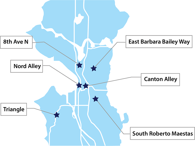
Today, six festival streets have been designated throughout the city. These include:
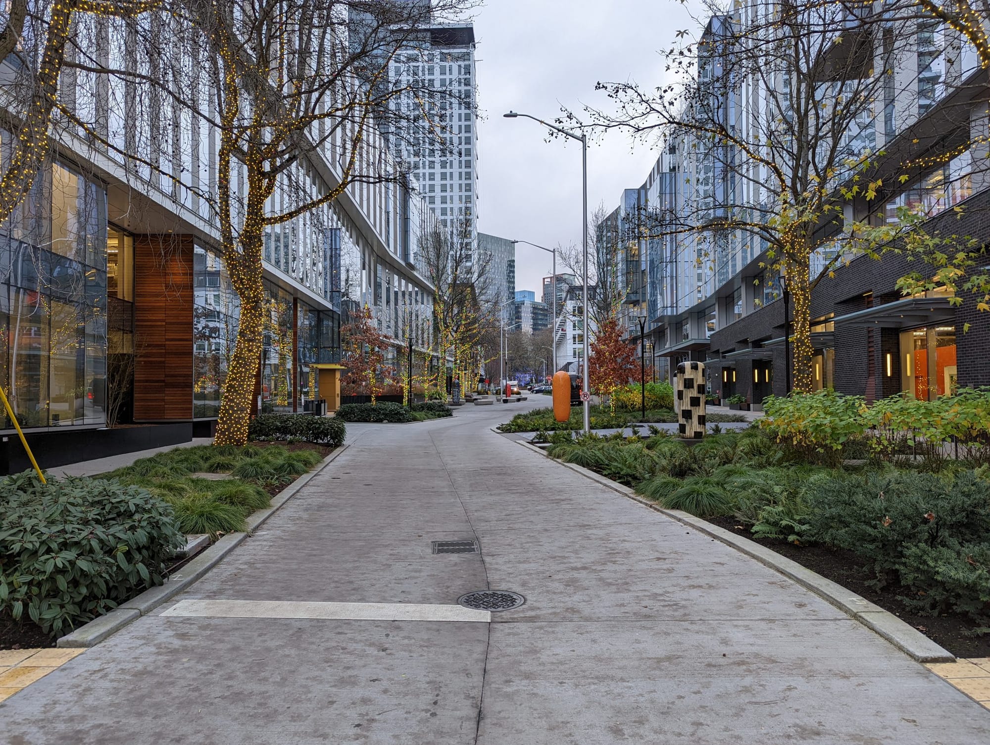
- 8th Avenue North, in between the two Arbor Blocks office buildings at Harrison Street/Thomas Street. The developers crafted this segment of street in South Lake Union to be especially friendly to pedestrians with a curving road, seating, open space, and trees.
- Canton Alley, which runs between the block bordered by South King Street, 8th Avenue South, South Weller Street, and 7th Avenue South. The alley was repaved in 2017. The alley derives historical significance from the surrounding East and West Kong Yick buildings that were constructed in 1910 to house Chinese American pioneers.
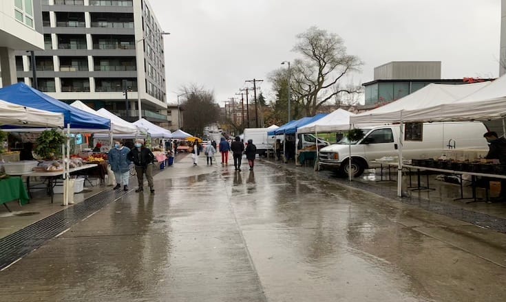
- East Barbara Bailey Way, between Broadway East and Nagle Place. This festival street is in the middle of the Capitol Hill light rail station transit-oriented development and right in front of an exit to the station. It is most commonly used for the Capitol Hill Farmers Market.
- Nord Alley, which runs between the block bordered by South Main Street, Occidental Avenue South, South Jackson Street, and 1st Avenue South. This alley was repaved in 2018, as a part of the same project as Canton Alley. This festival street most recently was the venue for costumed dogs earlier this month.
- South Roberto Maestas Street, between 16th Avenue South and 17th Avenue South in Beacon Hill. This street is in the middle of the Beacon Hill transit-oriented development, light rail station, and the El Centro De La Raza Building.
- Southwest Snoqualmie Street, between 37th Avenue Southwest and 36th Avenue Southwest. Known as the Triangle Festival Street, this street is located just south of the West Seattle YMCA. Designation of this street was part of the West Seattle YMCA’s Expansion and Renovation project.

The rules for creating a new festival street
The latest rules document for festival streets came in January 2019, when SDOT Director’s Rule 1-2019 went into effect. Among the first topics discussed was the director of SDOT’s power to authorize the rules of the festival streets program including all of the duties needed for implementation. The document also describes definitions, considerations for new festival streets, the designation process, the removal process, and permitting rules.
When it comes to what streets might make for strong festival street contenders, only non-arterial streets and alleys may be designated as festival streets and that intersections are excluded. The rules outline a long list of street types categorized as ranging from very appropriate to inappropriate for festival street consideration. The most appropriate street types include those that are direct links to major transit facilities, like East Barbara Bailey Way near the Capitol Hill light rail station, and those located in pedestrian-oriented neighborhood commercial areas, such as Nord Alley in Pioneer Square. Streets that do not require major detours if closed to vehicle traffic and with little to no impact to paid parking are also deemed to be good candidates for festival streets. Less appropriate street types include streets that serve mostly single-family residences, and thus include multiple driveways, streets whose closure would affect access to or loading around transit facilities, and those on emergency routes.
Designation is the longest process described in the 2019 rules document. First of all, anyone can submit an application to the SDOT director requesting that a street be designated as a festival street. As part of the process, the applicant must to alert the surrounding community. Communication materials have to include location of the proposed festival street, contact person and their information, and notes on where additional information can be found. The outreach also has to be culturally-competent. Additionally, a site plan, documentation of outreach, summary of feedback, adjacent property contract information, proposed traffic control plan, and applicable Certificates of Approval from SDOT also need to be included before a review of the application can be done. Once all those requirements are met, the SDOT director can make a decision
The removal process for a festival street is similar, but a bit easier to undertake. Anyone can request removal of a festival street designation using the same communication and outreach process. To qualify for review by the SDOT director, only the reason for the removal request, documentation of outreach, summary of feedback, and adjacent property contact information need to be provided.

Applying for a SDOT Street Use festival street permit is fairly straightforward. Only designated streets can apply for these permits. Permit holders are responsible for traffic control measures specified in the plan submitted during designation. Uses for festival streets are specified in a document — Client Assistance Memo 2504 — that is not readily available, but an older version of it does exist. Only one permit and fee payment are required a year, so neighborhoods are encouraged to frequently use these designated places. The permit just needs to contain a schedule and activities that are then pre-approved for an entire year.
A less certain future for a Crown Hill festival street
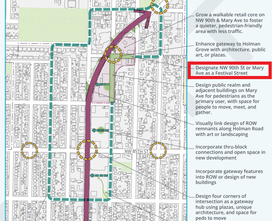
A festival street would be a powerful addition to a pedestrian loop in Crown Hill, but current rules would heavily constrain the bounds of a potential Crown Hill festival street. First of all, an applicant from Crown Hill would have to choose between two the contending streets, Northwest 90th Street and Mary Avenue Northwest, because unfortunately these streets connect at a disqualifying intersection. Mary Avenue Northwest in particular serves a lot of single-family residential development, but both streets include driveways that are the only access to parking spaces. Thus, unless rules change or the conditions of those streets change, a festival street in Crown Hill would be either unfeasible or severely truncated.
But even Seattle’s existing festival streets are constrained to small segments, ranging from under 200 feet to roughly 400 feet in length. Larger pedestrianized zone categories exist in SDOT’s rulebook, but they are not within the power of the SDOT director. For example, pedestrian plazas can be recommended by the director of SDOT, but City Council approval is required for implementation. Festival streets have been designed to be small, but with some changes, they could be much more significant in their impact.
In the next year, Seattle will be getting a new SDOT director as a result of Mayor-Elect Bruce Harrell’s announcement of department leadership changes. Who knows what a future director might change for festival streets, but until we have a sense of who will hold the position, worries will persist around what Harrell’s statement of “recognizing the role of cars” in Seattle transportation may mean for the pedestrian-friendly festival streets program.
Seattle’s State Transportation Priorities for 2022: Pedestrian Streets and Freeway Removal
Four Years Later, Seattle Emissions-Free Area Has Gone From Promise to Draft Plan