As traffic fatalities in Seattle follow a national upward trend, the Seattle Department of Transportation is under increasing pressure to make investments that improve safety on the city’s streets. Following a $1.3 million allocation in Bruce Harrell’s proposed 2023 budget, SDOT is going after a much bigger prize: help from the federal government. Late this summer, the department applied for a new Safe Streets for All grant from the U.S. Department of Transportation, making an ask for $30 million in federal dollars to make safety improvements in areas around the city.
SDOT is requesting the maximum amount from the brand new grant program funded by last year’s Infrastructure Investment and Jobs Act (IIJA), which USDOT describes as intended to “improve roadway safety by significantly reducing or eliminating roadway fatalities and serious injuries through safety action plan development and implementation focused on all users.” The grant application outlines a laundry list of street changes that the city would make with the funding, which would be supplemented by a $7.5 million local match.
SDOT’s proposal leans into the USDOT criteria for the grant, which asks localities to calculate the percentage of investments that would go to “underserved communities”, as defined by census tracts that have residents with a higher-than-average share of socioeconomic inequality. 97% of the projects proposed here by SDOT are located inside those tracts, which the department notes are also the areas where the majority of fatal and serious injury crashes happen in the city. Most of the investments are focused on areas in Council District 2, the Rainier Valley and SoDo, with the University District, the far north end of the city, downtown, and areas of West Seattle also included.
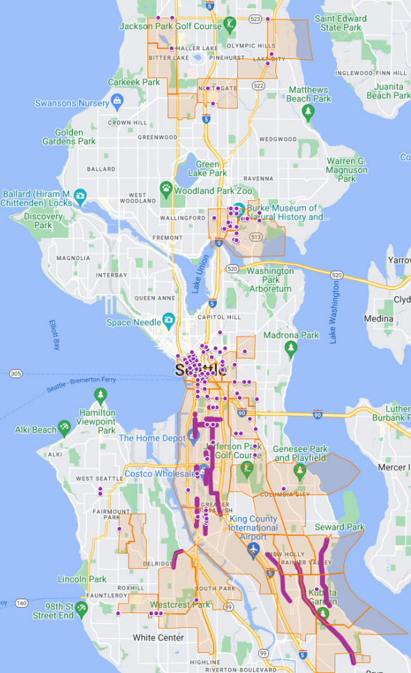
The application provides a big insight into what SDOT sees as the most urgent safety investments that the city could be making right now. The most funding (43.7%) in the proposal is aimed at individual intersection treatments: adding signals, creating curb ramps, putting in Accessible Pedestrian Signals (APS) that provide audio cues about when it’s safe to cross the street. Fewer than a quarter of the intersections in Seattle have APS, and a wider roll out has been slow in coming.
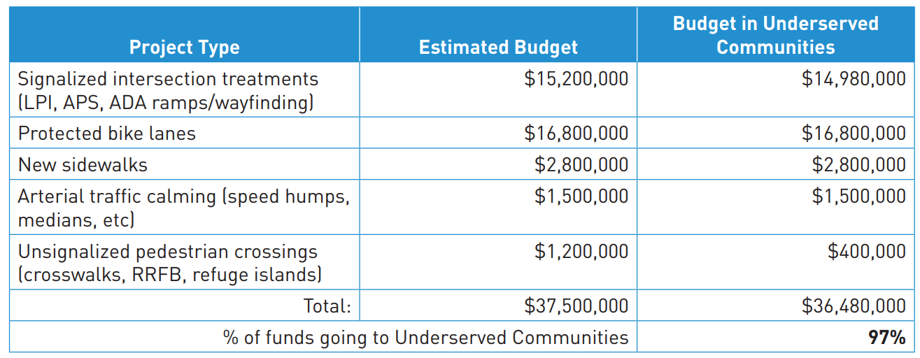
That translates to 117 intersection upgrades, but only a small segment of those intersections — just six — would see new marked crosswalks or rapid flashing beacons in addition to the new ramps and APS. Around half would see Leading Pedestrian Intervals (LPIs) added, the few-second head start before a green light that allows pedestrians to step off the curb and become more visible before drivers start turning. 58 intersection improvements would consist of just new curb ramps and APS.
“40% of serious injury and fatal pedestrian collisions occur at signalized intersections. This increases to 75% for people who utilize mobility devices and may be less visible to turning drivers at traffic signals,” the application states. “Among the locations identified for treatment, 107 fall within the top 10% of citywide intersections for high pedestrian risk factors, 3 locations fall within the top 15%, and 110 locations identified are rated either severely deficient or completely deficient for accessible pedestrian signals and ADA ramps.”
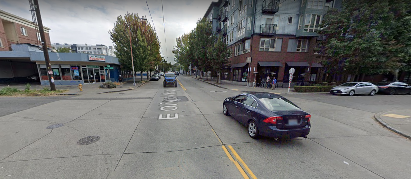
Among the intersections without signals that would get upgraded are some of the trickiest crossings in the city, like E Olive Way at Harvard Avenue E near Capitol Hill Station and 8th Avenue NE and NE 42nd Street in the U District.
Just $1.5 million of the $37.5 million would go toward corridor traffic calming projects, along Renton Avenue S between MLK Jr Way S and the south city limit and along Seward Park Avenue S between S Morgan Street and Rainier Avenue. Street redesigns like Rainier Avenue between Columbia City and Hillman City have been incredibly successful, with the city seeing high-end speeding down by 75% and collisions involving people walking or biking down 40% after the redesign, but the City is still not widely deploying them elsewhere.
The Urbanist asked SDOT about the relative lack of focus on arterial traffic calming in this grant application.
“SDOT is continuing to develop larger arterial traffic calming efforts in coordination with the Seattle Fire Department and we will likely be utilizing more local funds for these projects in the future,” SDOT spokesperson Mariam Ali said. “The arterial traffic calming treatments cover close to 5 miles of locations. These represent 2-lane collector arterials with high vehicle speeds over the posted speed limits and are good candidates for arterial traffic calming treatments. The SS4A program will have an annual application and it’s possible that as certain corridor-level traffic calming projects are further developed they could be included in future SS4A applications.”
This is the first year of this grant program, and it remains to be seen how competitive the applications are, but Seattle being successful at winning an award this early in the program could mean the city is less likely to receive funding in those future cycles.
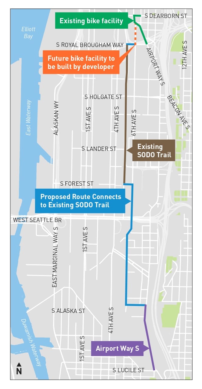
The second largest component of the package would create three sets of new protected bike lanes. The Georgetown to SoDo bike route would create a bike connection to the SoDo trail from both Georgetown and the far south end of the International District, the third phase of the Beacon Hill bike route would connect South Myrtle Street with the tail end of Beacon Ave at 39th Avenue S, and a new bike route would be created on Highland Park Way SW to connect the Duwamish trail with the rest of West Seattle. These four miles of protected bike lanes seem specifically designed to build on other connections the department is making, such as the rest of the Beacon Hill route and the completion of the Duwamish trail on East Marginal.
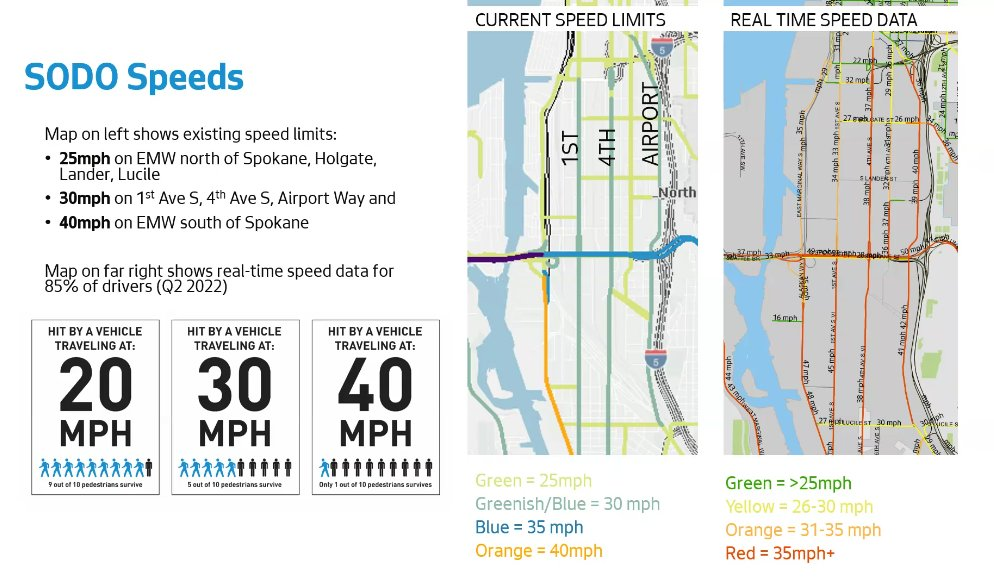
Finally, the proposal would add 1.5 miles of new sidewalks, all to streets in SoDo. An incredibly disproportionate share of the city’s traffic fatalities happen in that neighborhood, but it’s not clear how many of those traffic fatalities would have been prevented with the added blocks of sidewalks, which are along 1st Ave S, 4th Avenue S, and S Holgate Street.

Earlier this year, when SDOT rolled out some proposed changes to 4th Avenue S near Holgate following the tragic death of Gan Hao Li in May, the department’s own data showed the high rates of speeding throughout SoDo. SoDo has some of the widest streets in the city, with seven and eight lanes on some of the north-south corridors: high speeds are clearly contributing to the low survival rate when people walking or biking are hit.
SDOT says more changes in SoDo are in planning, just not with this grant. “The Vision Zero program is currently focusing early planning efforts (with local funding) on SODO,” Ali said. “Full planning, design, and community engagement have not yet occurred, though when it does and if there is funding needed to support implementation beyond available City funding, we would likely seek future SS4A or other grant funds to support.”
A large scale investment like this in safety across the city may be the city’s only hope of reversing the escalating trend of people being seriously hurt and killed in traffic. This large Safe Streets For All grant application represents the city of Seattle’s first big request for street improvement funding available from the IIJA, with SDOT having skipped applying for funding from the expanded RAISE grant program this year. Along with the Reconnecting Communities grant program, which would be a good fit for the Reconnect South Park proposal, there are some big opportunities for Seattle to transform its streets and public spaces with this added funding from the federal government over the next few years. Even the applications that aren’t successful tell us a lot about where city leadership is headed.
WSDOT Holds Back on Going After Grants to Fix State Highways