A series of pedestrian bridges in Kirkland and Redmond will make it easier to navigate the Eastside by walking or biking following grand openings scheduled in the coming month. Beefing up the significant and growing network of off-street multi-use trails that make up the spines of east King County’s non-motorized travel network, all three bridges are connecting areas that have long been divided by car infrastructure, not natural barriers, and all have been in the works for well over a decade.
Totem Lake Connector
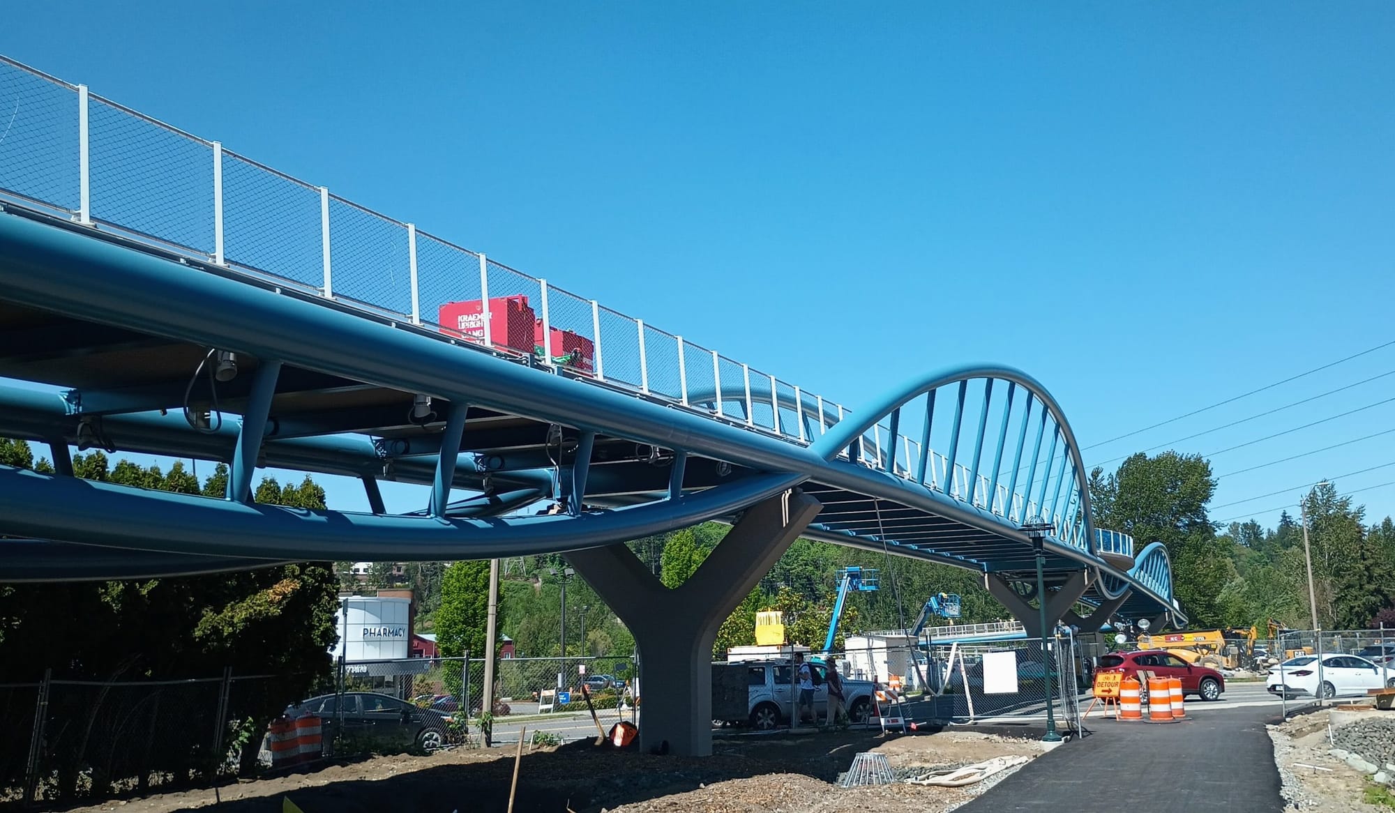
The first of these major bridge openings is just a few weeks away. On Saturday, July 8, Kirkland will open a $22.3 million bike and pedestrian bridge that will fill in the final gap on the city’s backbone of a regional multi-use trail, the Cross Kirkland Corridor. The mostly gravel trail makes up nearly six miles of the ever-expanding Eastrail corridor that is envisioned as a 42-mile connection south to Renton and north into Snohomish County.
The Totem Lake Connector (TLC) brings the Cross Kirkland Corridor above the wide, awkward, and congested intersection where Totem Lake Boulevard meets NE 124th Street, allowing trail users to skip the whole thing. Right now, the only way for people biking to pass through the area was to use the traffic lanes or the incredibly narrow sidewalks. Last fall, The Urbanist’s Shaun Kuo detailed the barriers that the neighborhood’s car-centric planning might be adding to efforts to create a neighborhood oriented around walking and biking, but without projects like the Totem Lake Connector the area would probably never get there.
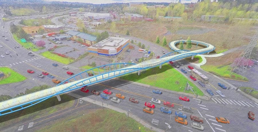
“The [Totem Lake Connector] bridge connects the two ends of the Cross Kirkland Corridor, providing direct access for residents and businesses to the Village at Totem Lake and to the growing Totem Lake area from other Kirkland neighborhoods. Next to Totem Lake Park, the TLC showcases the balance between urban and natural environmental settings,” Rod Steitzer, Capital Projects Manager at Kirkland Public Works, told The Urbanist. “The new TLC bridge prepares Kirkland’s only designated urban center for future regional growth, giving people more options on how they might navigate the urban center, as Eastrail projects continue to be planned and built north and south of Kirkland.”
Bike riders venturing off the Cross Kirkland Corridor won’t find many separated bike facilities along Kirkland’s arterial streets, though that is slowly changing. This year, the city starts construction on adding protected bike lanes to 124th Avenue NE down to NE 116th Street — but only as part of a larger project that is widening the street from three to five lanes.
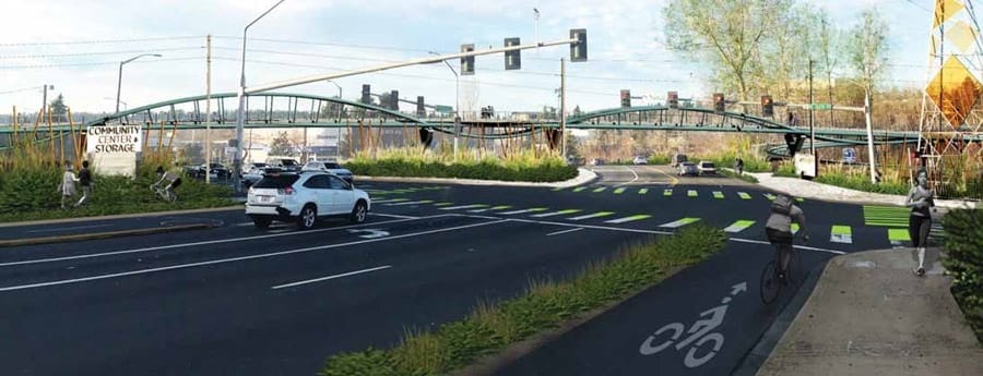
Last year, the Kirkland City Council approved an increase in the city’s vehicle license fee that’s set to be specifically dedicated to adding active transportation infrastructure. New sidewalks across the city will be the biggest gain from the city’s spending plan for that new fund, but the bike infrastructure upgrades will mostly come in the form of new paint, not separated lanes that keep people on bikes away from motor vehicles.
Overlake Village Pedestrian Bridge
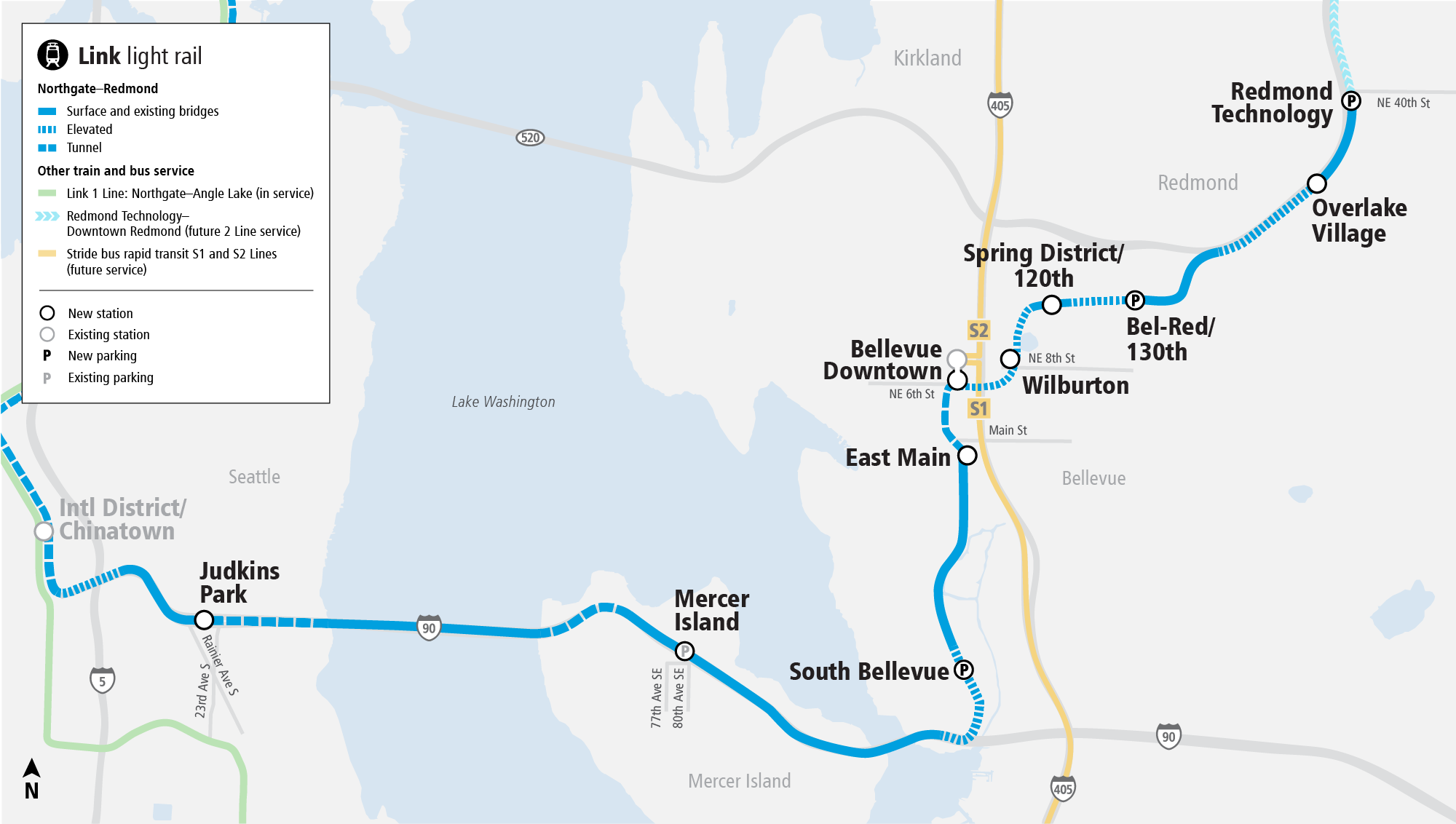
While the potential start of service for Sound Transit’s East Link extension is still very much up-in-the-air right now, two major new pieces of associated pedestrian and bike infrastructure are heading toward grand openings that are going to be completely independent of whether trains are running. The two new bridges across State Route 520 in Redmond, will knit that city’s growing bike network together much more closely with the regional asset that is the 520 multi-use trail.
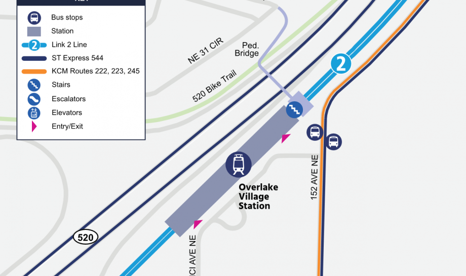
The first bridge, which is opening later this summer, connects to the Overlake Village light rail station, providing a new connection where one didn’t exist between 148th Avenue NE and NE 36th Street, directly at the bus stops serving Overlake Village Station on 152nd Avenue NE. For the bridge’s interior, Sound Transit commissioned work from Seattle artist, Leo Berk, which is made of more than 156,000 hand-painted tiles creating a natural image intended to evoke the early computer age, a nod to Microsoft, whose sprawling 500-acre headquarters is in the Overlake neighborhood.

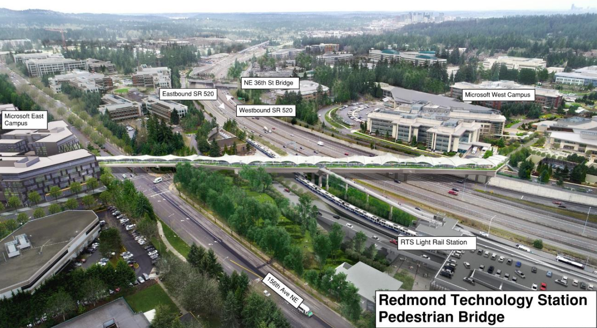
Redmond Technology Center Bridge
A half-mile north of the Overlake bridge, a significantly larger bridge is taking shape at Sound Transit’s next station, dubbed “Redmond Technology.” Not only will this bridge connect users on the 520 Trail across the highway to the light rail station, it will also bridge across 156th Avenue NE. Directly connecting two sides of Microsoft’s campus to each other, the bridge is being fully funded by the tech company but will be owned by the City of Redmond. Like the Overlake bridge, this bridge is fully covered, protecting users from the elements.
“Redmond will benefit tremendously from two new bicycle and pedestrian bridges crossing SR 520,” said Kelli Refer, executive director of Move Redmond and a boardmember at The Urbanist. “The Overlake neighborhood is experiencing tremendous growth and change with the investment of light rail coming to the area. More housing and mixed-use transit oriented developments are being built in Overlake because it is a key urban growth center for the City of Redmond. For people who walk and bike in Overlake there will now be two bridges that provide access across SR-520 and help people navigate off of the SR-520 Trail into the retail core of the neighborhood.”
Jill Smith, Communications Manager at the City of Redmond, said that the Redmond Technology Center bridge is set to open as early as the beginning of 2024, after the west approach to the bridge and the connection to the 520 Trail is complete.
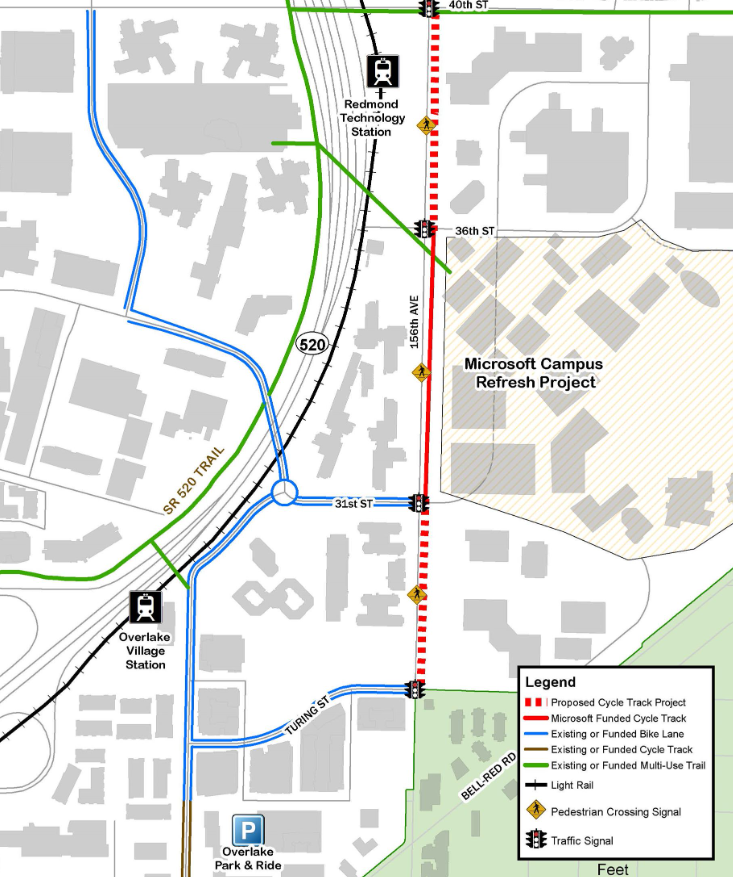
Like Kirkland, Redmond is beefing up its local bike network around the new bridges, but with even more protected infrastructure that will be available to users around the time that trains are running. The city has already opened a new shared use path along NE 40th Street, and a new cycletrack on 156th Ave NE will serve the east side of both pedestrian bridges.
“For the first time we are seeing a connected network of bicycle facilities in Redmond that connect the trails network to the key neighborhood destinations,” Refer said. “This is a big shift [from] seeing bicycling as recreational activity to a means of everyday transportation.”
All three of these new bridges have the potential to catalyze usage of the Eastside’s popular and incredibly valuable off-street trail network and increase demand for more on-street bike infrastructure to create more connections. Their impending completion is worthy of celebration.