Seattle Subway isn’t an organization to rest on its laurels. Fresh off Sound Transit 3 (ST3) success–with voters greenlighting 62 miles of light rail and two bus rapid transit corridors–Seattle Subway continues to keep an eye on the next transit measure.
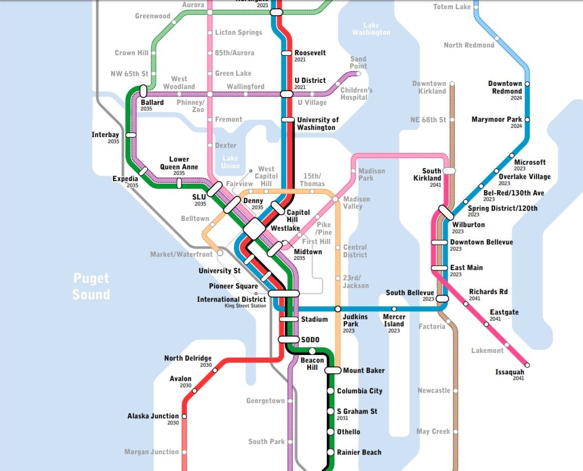
This is a yearly ritual for all-volunteer-run organization; this year Seattle Subway Executive Director Keith Kyle said the tweaks are geared toward zeroing in on lines that are attractive for future transit measures. As you can tell from the map, Seattle will be a centerpiece, but there are some interesting additions for the suburbs too. The major differences from past maps (like the 2018 and 2017 versions) include extending the Aurora line to Edmonds, picking up Shoreline along the way and extending the Metro 8–named because it would turn the perpetually late Route 8 bus into a workhorse rapid transit line–to Belltown and Pike Place Market.
“There’s a lot of people really excited about the Metro 8 line,” Kyle said. “So we kinda spent some time thinking about what would it look like if you could really pull in neighborhoods that aren’t getting great service. How would you improve service to a lot of dense areas? I haven’t seen a version of the Metro 8, for example, that serves Belltown before or that tries to serve the [Seattle] Waterfront.”
With the 2019 tweaks, the Metro 8’s eastern terminus would be Mount Baker and its western terminus would be Pike Place Market, pulling in the Waterfront, which will soon get a big-time makeover. Along the way, it’d pick up Belltown, Denny Triangle (interlining with the Green Line’s Denny station), South Lake Union, Summit Slope (aka East Capitol Hill), and Western Capitol Hill with a 15th Avenue stop. From here on, the Metro 8 follows the same course as last year’s version–next stop Madison Valley, where it’d connect with a Madison Rapid Transit line that the map envisions crossing Lake Washington to Kirkland and interlining with the planned Issaquah line from the ST3 map. It’d also serve the Central District with two stops and Judkins Park, connecting with East Link.
One place the vision map’s Metro 8 subway doesn’t serve is Capitol Hill Station. Perhaps this is a nod to the difficulty at shoehorning another station next to the existing one or to the overcrowding that could result if they do. The benefit of such an alignment is that the Metro 8 would get to serve other parts of Capitol Hill, but the lack of an easy connection between lines would be a drawback from a user standpoint.
The extension of the Aurora Avenue line to Edmonds was based on feedback received on the last vision map, Kyle said, as people asked why the Magenta line stopped at the Seattle border (the magenta color is now officially pink this year). This version keeps on rolling down Aurora and eventually swoops over to Edmonds. If the next phase is funded at the city level, then that would mean Shoreline and Edmonds would need to support funding the rail extension for the Edmonds extension to happen.
The vision map exercise isn’t necessarily geared toward sorting out all the technical questions. Instead, it’s about galvanizing support and keeping momentum going to expand rapid transit in the region. After missing many transit opportunities in previous generations, many transit advocates want to fully seize the opportunities before us today.
“I don’t think a lot of people think that Ballard and West Seattle is the end of a transit system expansion and high quality rail in Seattle,” Kyle said. “I don’t think a lot of people look at that map and say it’s done. It’s not done. It was the next step. It was a huge step forward, but we really need to take the next step forward beyond that.”
Thinking about the next step now has its benefits. Seattle Subway looks at developing a long-range plan beyond ST3 as a way to speed up delivery of projects.
“The biggest thing we hear is these things take too long to build,” Kyle said. “We have to keep as many projects in the pipeline as quickly as we can now so that when they start coming to fruition, it’s just one after the other, and we get all of that network effect and all the investments that we’ve already made start paying off more.”
With expensive central pieces of Seattle’s light rail network already funded and under development, adding an elevated Aurora Aurora line and extending the lines beyond Alaska Junction and beyond Ballard will be a lot cheaper per mile. A big reason why the extensions would be more inexpensive is that they largely could be elevated, and elevated rail tends to be about four times cheaper than deep-bored tunnels, Kyle said. One could argue it’d be foolish not to extend the lines with the difficult and expensive part done.
“When you reuse the second downtown tunnel to do an Aurora line, well the downtown tunnel is extremely expensive, extremely hard to do, but then if you were to go to elevated [rail] on Aurora, it’d be relatively inexpensive. You’re taking advantage of these huge investments that we’ve decided to make as a region, and really building out a Seattle subway, and that’s obviously our goal–it’s right in our name,” Kyle concluded with a laugh.