1st Avenue W in Greenwood has been a Stay Healthy Street since April 24. (Photo by Dongho Chang)

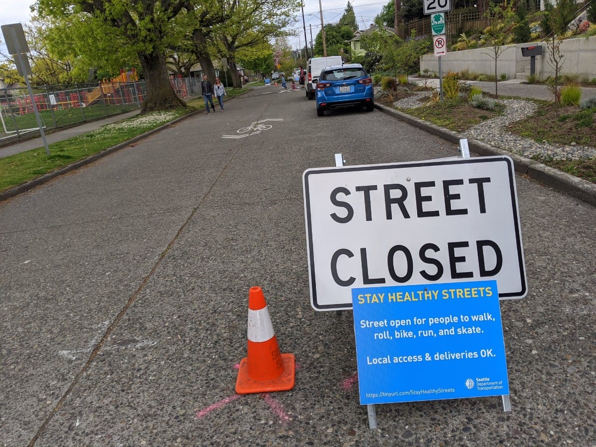
Walking, rolling, or biking through Seattle got a little easier thanks to another expansion of the Stay Healthy Streets program. The Seattle Department of Transportation (SDOT) revealed today 11 more miles are joining the program. The neighborhoods joining the party this weekend are Ballard, Aurora-Licton Springs, Lake City, and Delridge/Highland Park.

Last Friday, the agency announced expansions in Beacon Hill, the Rainier Valley, and Greenwood, stretching nine total miles with the Stay Healthy Streets already underway in the Central District and High Point. This weekend’s expansion brings the program to 20 miles.

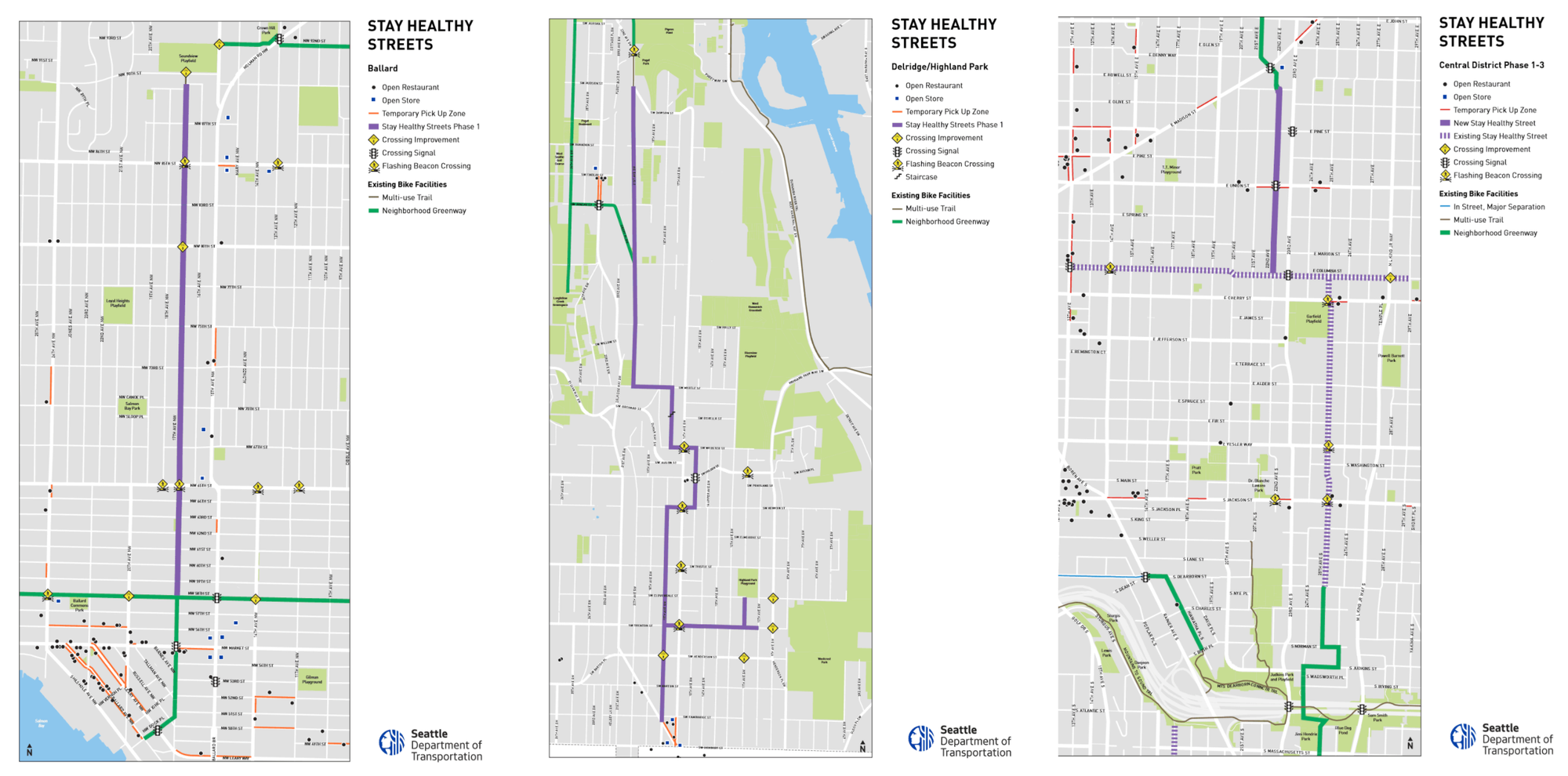
The Ballard route uses 17th Avenue NW (Ballard map here) from NW 90th Street to NW 58th Street. At that point, people are left to use existing Neighborhood Greenway infrastructure to reach the heart of Ballard by heading south on 17th Avenue NW or east or west on NW 58th Street. Those greenways fall short of ALEGRA (all ethnicities, genders, races, and abilities) standards, but they’re better than nothing.

Stay Healthy Streets network in Ballard, Delridge/Highland Park, and Central District. Solid purple lines are new Stay Healthy Streets, dashed purples lines are existing Stay Healthy Streets, green lines are existing Neighborhood Greenways, and orange lines are temporary pickup zones. (City of Seattle)

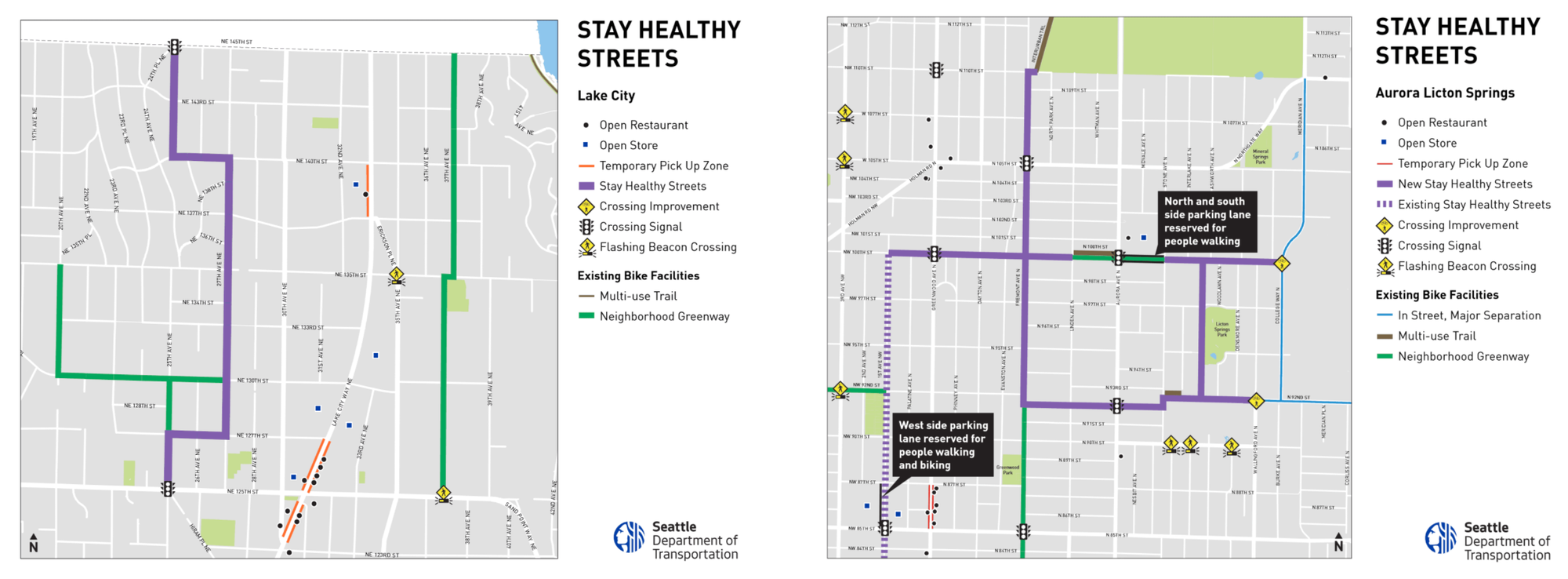
Aurora-Licton Springs is getting a grid of Stay Healthy Streets (Aurora map here) with Fremont Avenue N, Ashworth Avenue N, and N 92nd Street forming a loop for those looking to do some laps. Fremont Avenue, already a Neighborhood Greenway, will be closed to through traffic from N 92nd Street to N 110th Street, at which point it connects to the Interurban Trail for a pleasant ride along the edge of the leafy Evergreen Washelli Cemetery. The N 100th Street closure extends west to connect to Greenwood’s Stay Healthy Street on 1st Avenue W.

27th Avenue NE is the primary Stay Healthy Street in Lake City (Lake City map here) in a route that stretches from NE 125th Street to the city’s edge at NE 145th Street–also using 25th Avenue NE for a good spell.

Stay Healthy Streets network in Lake City and Aurora-Licton Springs. Solid purple lines are new Stay Healthy Streets, dashed purples lines are existing Stay Healthy Streets, green lines are existing Neighborhood Greenways, and orange lines are temporary pickup zones. (City of Seattle)

The Delridge route uses 21st Avenue SW from Puget Park south to SW Myrtle Street and zizzags around before settling on 17th Avenue SW as the route through Highland Park (Delridge map here). There’s also an eastward branch at SW Trenton Street to reach the Highland Park Playground and get within a few blocks of Westcrest Park.

Our transportation reporter Ryan Packer pointed out that today’s good news is tempered by the fact that the program hasn’t touched many of Seattle densest neighborhoods most sorely in need of social distancing help. First Hill, Capitol Hill, Uptown, Belltown, Chinatown-International District continue to lack a prominent Stay Healthy Street. The need is acute since nearly 90,000 people live in the few square miles that compose the Downtown core and more than 30,000 people live on Capitol Hill.

The University District remains without a Stay Healthy Streets even though car ownership is low and grassroots support for pedestrianizing streets here is well established. Other apartment-heavy neighborhoods like Columbia City, Roosevelt, Fremont, Wallingford, Bitter Lake, Northgate, and Alaska Junction are also waiting. The core of Ballard is still waiting too, even if the north end of the neighborhood got a street.

Bigger sized map of the Ballard Stay Healthy Streets corridor. (City of Seattle)

Seizing low-hanging fruit is an understandable strategy for the City to take. But for the Stay Healthy Streets program to have its full intended impact, reaching the busiest and most apartment-heavy neighborhoods has to be on the agenda. It’s not an equitable arrangement to ignore our Urban Centers while lavishing attention on single-family neighborhoods.

But, for now, we’re thankful for what we’ve got–SDOT got us to 20 miles in just a few short weeks. Seattle Neighborhood Greenways should also be commended for leading the charge and helping to facilitate the program. Let’s build on this solid foundation.

The featured image is by SDOT Traffic Engineer Dongho Chang.

Article Author
Publisher | Website

Doug Trumm is publisher of The Urbanist. An Urbanist writer since 2015, he dreams of pedestrianizing streets, blanketing the city in bus lanes, and unleashing a mass timber building spree to end the affordable housing shortage and avert our coming climate catastrophe. He graduated from the Evans School of Public Policy and Governance at the University of Washington in 2019. He lives in East Fremont and loves to explore the city on his bike.