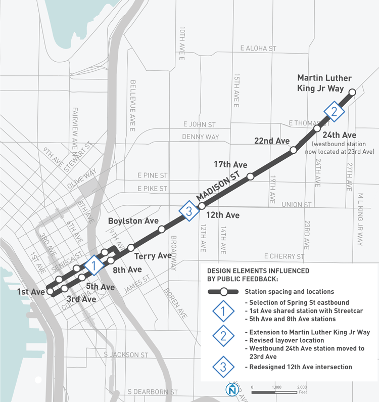
The RapidRide G Line (aka Madison BRT) is in the final stretch of the planning process. Public comment on a draft proposal has closed, sending the project back to engineers and planners to make final tweaks to the design prior to construction. The 2.3-mile enhanced bus line spanning First Avenue in Downtown Seattle to Martin King Luther Jr Way in Madison Valley is poised to break ground in 2018 and open for service in late 2019, according to a City timeline. The recent proposal has sparked concern amongst advocates for all-ages and abilities bike facilities due to the proposal scaling back of bike investments–particularly of the kind that would make a legible, efficient network. And earlier in the design process, transit advocates had their own reservations about the commitment to fast, accessible, and reliable transit service on the corridor.
Benefits
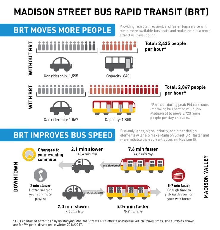
The Seattle Department of Transportation (SDOT) anticipates that the RapidRide G Line will boost bus capacity on the corridor by 960 riders per hour and increase the total net throughput of the corridor by 432 people per hour when counting car ridership, the latter of which is expected to decline as part of the project. Travel times between Downtown and the Madison Valley are also projected to be reduced by 7.6 minutes westbound (14.9 minutes total end to end) and 5.0 minutes eastbound (15.8 minutes total end to end) for transit riders.
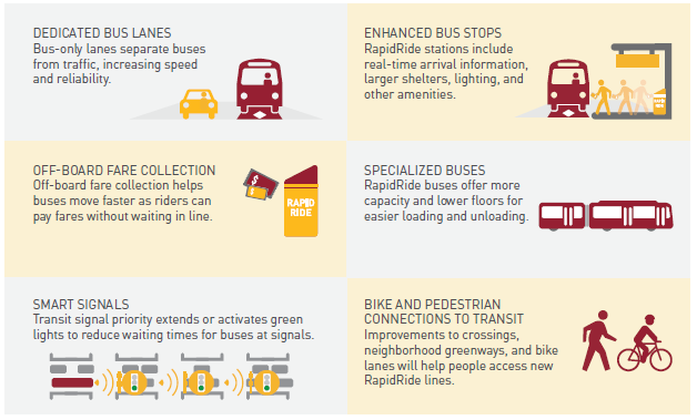
SDOT will use three-door boarding for buses with doors on both sides to accommodate the unique center-street platform boarding scheme that some station stops will have. All stations stops will have level-door boarding for buses and provide off-board payment. Combined, these measures will make the boarding process much quicker at stations, similar to other RapidRide lines except that all station stops will have these features. In addition to these services, SDOT plans to make other targeted improvements with bus lanes and transit signal priority.
Latest Design Proposal
The bulk of the enhanced bus line west of 19th Ave would benefit from exclusive transit lanes and selective turn-only/business access and transit (BAT) lanes. The remainder of the line west of 19th Ave would only have small bus-only and BAT lane segments. And at the terminus of the line at Martin King Luther Jr Way, there would be layover space for buses turning back toward runs Downtown.
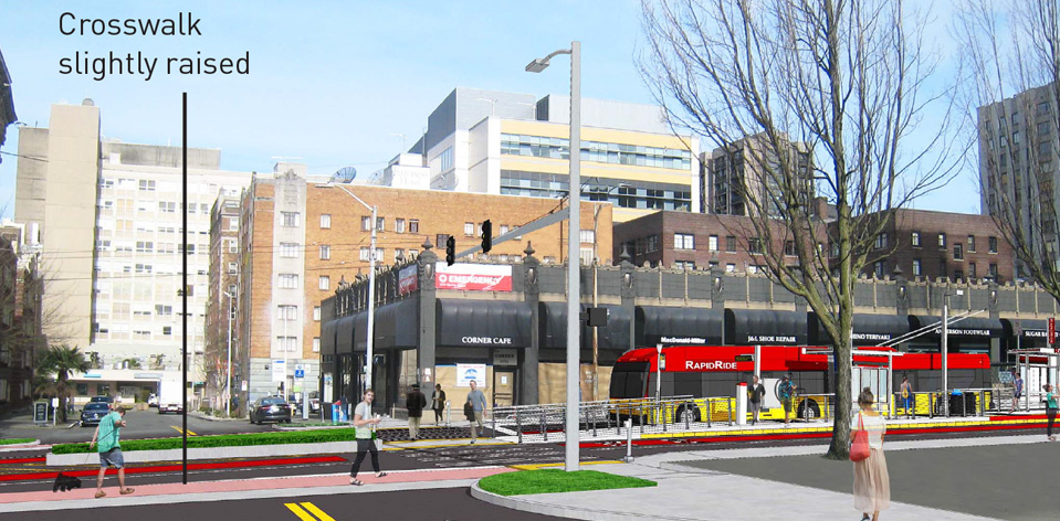
Throughout the corridor, SDOT will make improvements to approach streets intersecting Madison. For instance, the approaches may be repaved, restriped for rechannelization, or entirely rebuilt by trimming down the width and modifying turning radii. One of the approaches commonly visible in the draft street design is the use of curb bulbs at intersections. Many of these proposed changes would positively improve pedestrian crossings and foster enhanced speed control and road safety.
A package of other enhancements are also proposed along many sections of the corridor, including: new drainage facilities, expanded curbs and sidewalks, new curb ramps and landscaping strips, and added vegetation (though some trees will be removed or replaced).
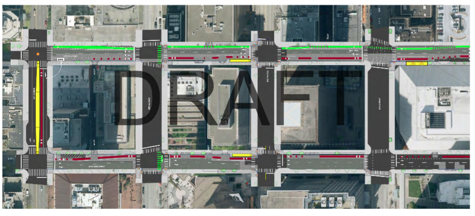
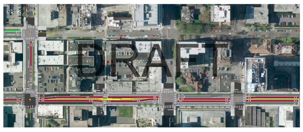
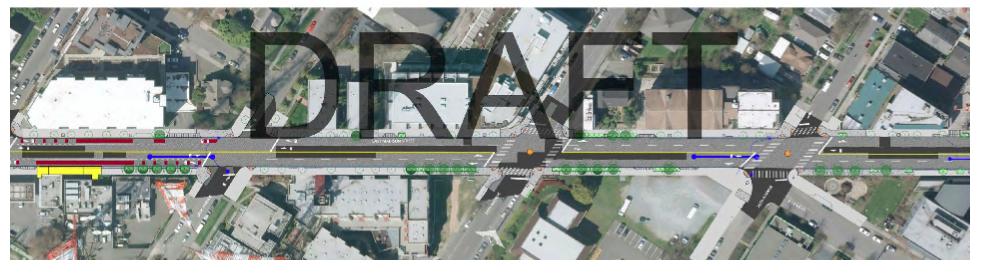
First Avenue to Ninth Avenue
The stretch between First Avenue and Ninth Avenue would form a one-way couplet for the line, in keeping with the existing one-way system already in place for Spring Street and Madison Street west of I-5. The corridor on that portion would of the line would only have about half exclusive lanes with stretches of BAT lanes to help buses have some level of priority on the street. A total of four stop pairs would be located on this portion of the line. The first stop would be constructed in the middle of the street as a standalone platform and shared with the future streetcar line while the other stop pairs would generally be located on right-hand side of the street for normal boarding. SDOT also is proposing a smattering of transit priority signals at key locations and new bike infrastructure, the latter of which is primarily planned to be located on the north side of Spring Street.
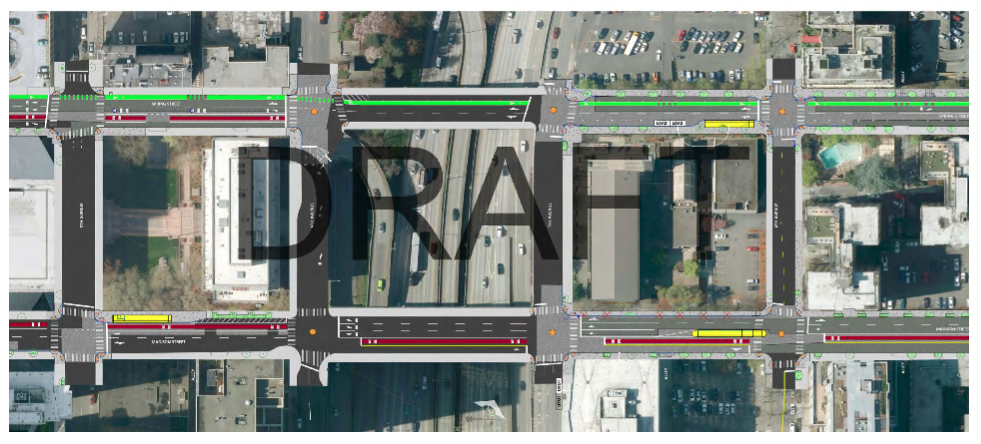
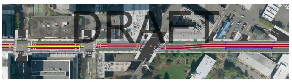
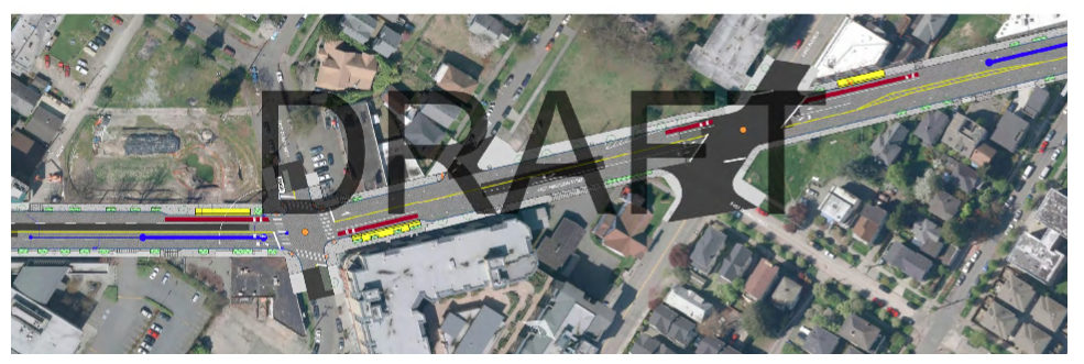
Ninth Avenue to 16th Avenue
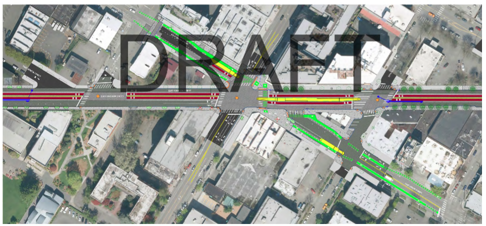
Between Ninth Avenue and 16th Avenue, the line would largely become center-running in the street with exclusive right-of-way for buses. Between 15th Avenue and 16th Avenue, buses will transition to and from center-running lanes and right-hand bus lanes. Three stops would be center platforms allowing left-door boarding of buses. SDOT plans to install transit signal priority at each intersection in this segment. For the five-way intersection at E Madison St, E Union St, and 12th Avenue, SDOT is planning to address pedestrian and bicycle circulation with a special treatment and provide a new stop pair for Route 2, which generally travels on E Union St in this area.
A separated bike facility is planned to be installed on E Union St, which would cross E Madison St and 12th Avenue. The bike facility is planned to a bike lanes on both sides of the street, except when crossing the five-way intersection. SDOT is proposing to create pedestrian-like marked crossings that zigzag the intersection to allow people biking to move through the space. A new pedestrian crossings would also be established at the northern portion of the intersection to help pedestrians move faster across the zone to the bus stop in the middle of E Madison St. This arrangement, however, is a very complicated piece of engineering given all of the road users being accommodated at a busy, irregular intersection.
Also worth noting, SDOT plans to improve the triangle island at E Pike St, 14th Avenue, and E Madison St. The space would be enlarged and receive a landscaping treatment to green it up from a concrete refuge for crossing pedestrians. The result of this would a westbound-only segment of E Pike St on the north side of the landscaped island.
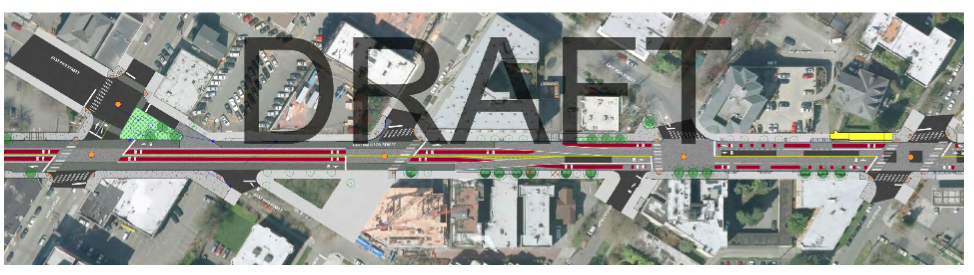
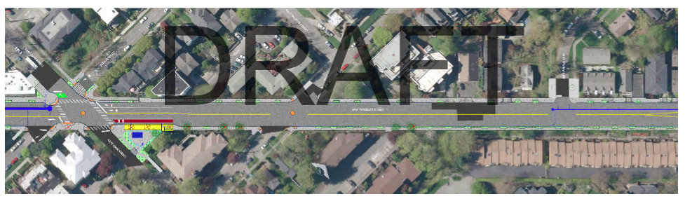
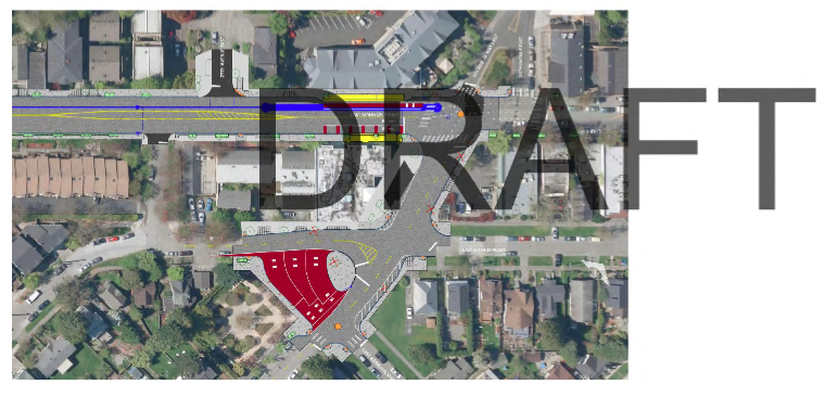
16th Avenue to Martin Luther King Jr Way
On this segment, buses would generally intermingle with regular traffic having only occasional exclusive or semi-exclusive bus lanes for priority. Intersections with signals would all get transit signal priority features to help speed buses through them. Lastly, new bus layover spaces would be located just off of Martin Luther King Jr Way next to a small triangle island at E Harrison St and Julia Lee’s Park. A total of three busy layover spaces would be installed to accommodate the buses.
Funding In Jeopardy
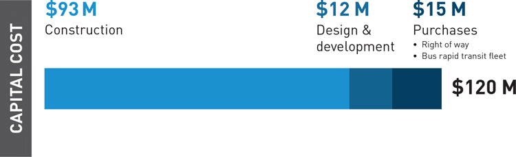
SDOT has estimated that the project will come in at approximately $120 million. More than two-thirds of the cost ($93 million) is committed to construction of the enhanced bus line facilities. The remaining $27 million is dedicated to planning, right-of-way acquisition, and procuring buses to operate the line.
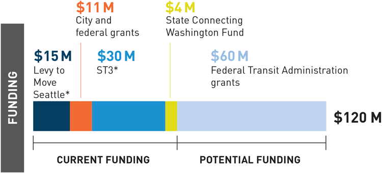
Funding the project involves a variety of sources with less than a quarter ($15 million) coming directly from the Seattle-voter approved Move Seattle Levy. A larger chunk of funding ($30 million) will come from the recently-authorized Sound Transit 3 measure. A mix of other grants by the City, state, and federal government are also anticipated. But half of the total funding ($60 million) is supposed to be sourced from the Federal Transit Administration (FTA). This funding, however, could be in jeopardy since it relies upon FTA Small Starts grants that are proposed for elimination by the White House. Traditionally, Congress has supported grant programs like Small Starts and TIGER, but pressure from the White House could scare the Republican majority into eliminating or at least heavily cutting back grant programs for transit projects.
Construction Timeline
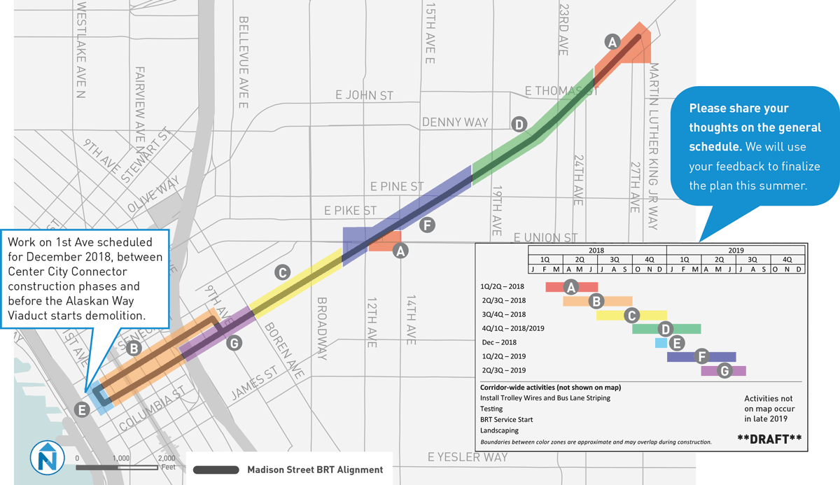
In a draft construction timeline, work on building the RapidRide G Line is slated to kick off in February 2018. SDOT plans to do construction work in segments and staggering project deliverables through overlapping timelines. The final section of work between I-5 and Boren Avenue is planned to wrap up Summer 2019. Other construction elements happening in late 2019 include trolley wire installation, bus lane striping, landscape installation, and bus testing. Before closing out 2019, RapidRide G Line buses should start moving passengers.
Madison Corridor Design – 3-8-17 by The Urbanist on Scribd
Related Articles
Madison BRT: An In-Depth Look At The 30% Design
Madison Could Earn Bronze-Standard BRT
Latest Madison BRT (RapidRide G) Designs Raise Concerns Around Bike Safety