A graphic shows jurisdiction with a Sound Transit station surrounded by mid-rise buildings for two blocks in each direction. The immediately adjacent blocks shows joined decision making, but the further out station areas land use is up to the City.
Sound Transit has big station decisions planned for 2022. The larger context of the station is planned in concert with the respective cities. (Image by Sound Transit)

Reaching the station platform could take six minutes at the deepest stations.

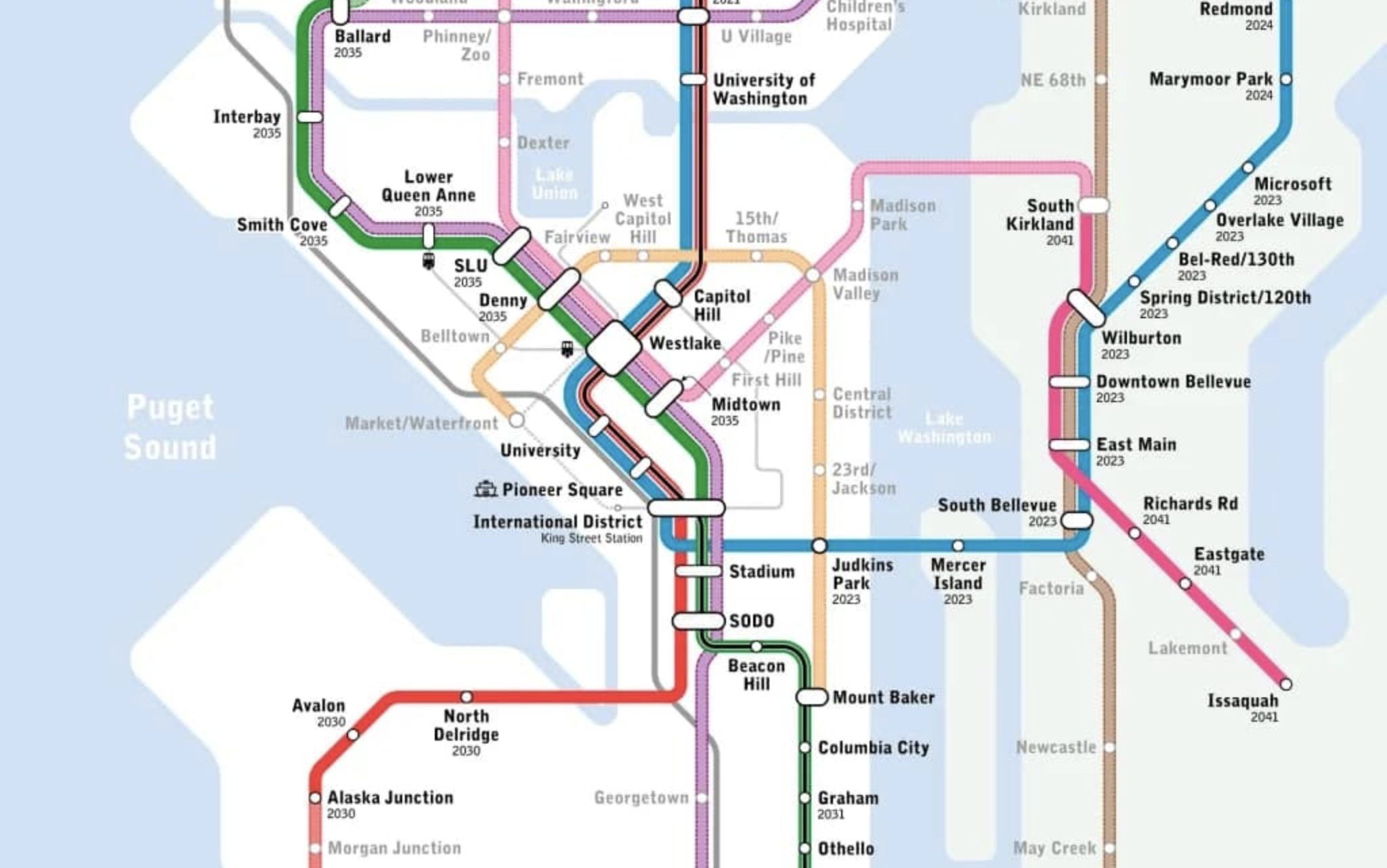
Sound Transit’s preferred alignment for the next phase of light rail in Seattle includes a Westlake Station that is 135 feet deep, a Midtown Station that is 140 feet deep, a South Lake Union Station that is 120 feet deep, and a Delridge Station platform that is 85 feet in the air. Chinatown-International District doesn’t have a preferred alternative yet, but one deep bore option is a whopping 190 feet deep.

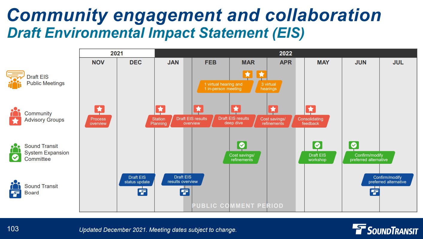
A fuller picture will emerge when Sound Transit releases its Draft Environmental Impact Statement (DEIS) for Ballard Link and West Seattle Link promised by January 28th, but the agency did reveal new morsels in presentations to its Community Advisory Groups over the past week. (Update: The agency released the Draft EIS on January 18th.)

“As one can expect with an elevator-only access configuration and deeper, those travel times do add up,” Sound Transit Land Use Planning Manager Sloan Dawson said in the agency’s presentation to the Chinatown-International District and SoDO Community Advisory Group yesterday. Dawson noted that shallower stations have shorter travel times.

Sound Transit has modeled travel times from the surface to the station platform at five to six minutes via escalator at Midtown Station and four to six minutes via escalator at the new Westlake Station, agency spokesperson Rachelle Cunningham said. Elevator times are two to three minutes at Midtown and three to five minutes at Westlake, but that quote does not appear to factor in waiting time in lines to get into the elevators, which can be very long at peak times, as users of the elevator-only Beacon Hill Station can attest. Sound Transit is considering elevator-only options for its deepest Midtown and Chinatown stations.

Already budget strain has pushed back Sound Transit 3 (ST3) some timelines a bit, which could be exacerbated by alignment decisions demanding more complex engineering and more costly construction. With the agency’s recent cost crunch, planning delays, and realignment decision, West Seattle Link is slated to open 2032 and Ballard Link is tentatively tabbed for 2037 (though it could potentially reach Smith Cove by 2035 under a phased opening scenario).

Unfortunately, super deep stations and awkward elevated alignments that require expensive land takings could be a recipe for further cost increases and engineering delays. It’s not too late, however, to correct course and fine tune the plan, as Sound Transit opens a round of public comment and engagement with the release of the DEIS.

Draft EIS results will be released January 28th, which kicks off three months of public comment. In March, Sound Transit will host four virtual hearing and one in-person public meeting. In May, Sound Transit staff will consolidate feedback and host a Draft EIS workshop with the Sound Transit System Expansion Committee. In June, that committee is scheduled to confirm or modify the preferred alternative. That recommendation will then go to the full Sound Transit Board in late June if all goes according to plan. (Credit: Sound Transit)

Sound Transit’s preferred alignment in Ballard would cross Salmon Bay on a new fixed high bridge at 14th Avenue NW and place the station at 14th and Market Street. Three other alternatives have made it into the DEIS, but the two tunnel options require “third-party funding” — mostly likely this means Seattle raising additional funds or securing them from the state legislature.

On the other side of Salmon Bay, the preferred alignment sandwiches the Interbay Station against the BNSF rail terminal rather than on 15th Avenue W, which is where the alternate station is located. Either alignment cites the Smith Cove Stations on Elliott Avenue W opposite the new Expedia Campus.

Once the line hits Uptown, the preferred alternative opts for deep bored tunnels and increasingly deep stations as it heads toward a that cavernous 140-feet-deep Midtown Station. The other studied alternative at Midtown is even deeper at 170 feet, but would offer an easier walk to First Hill — once that pedestrian gets their turn in the elevator, as escalators are not proposed given the incredible depth. That alternate option would be the deepest station in the region, besting Beacon Hill Station’s 160-foot depth.

However, that station could be one upped (or is it one-downed?) by an alternative under serious consideration at Chinatown-International Station, which could be 190 feet deep. Officially, Sound Transit doesn’t have a preferred alternative for this station, but the agency is under considerable pressure from some Chinatown-International District business owners and stakeholders to avoid the long street closure that a shallower cut-and-cover option would likely entail, either on 4th or 5th Avenue S.

Most transit agencies avoid building at such depths, but there are exceptions, such as the Moscow Metro and Tokyo’s Fukutoshin Line. Moscow’s reason for building so deep was to reach a clay layer of soil that is much more favorable for subway building than other soil conditions in the city. In Fukutoshin’s case, existing subway lines or reserved subterranean rights for future extensions pushed that line deeper to avoid conflict.

The Urbanist submitted questions to Sound Transit seeking more insight into why the stations are so deep and how alternatives were ruled out, but many of our questions were returned with ‘wait for the DEIS’ as the answer. We did get a general overview of the factors pushing the agency toward deep stations.

“The primary drivers include the existing terrain in the Downtown area; soil properties and underground utilities; light rail operational requirements such as how steep light rail can climb, and special track work; high-rise buildings with underground tiebacks; and other underground infrastructure such as the existing light rail tunnel, and SR-99 north tunnel portal,” Cunningham said in an email.

This map shows the alignment and station options under consideration in the Draft EIS. (Sound Transit)

The new Westlake Station, like the Fukutoshin Line, involves a delicate dance with another underground transit line — the existing Link Line 1 (aka Central Link). The newer line is forced to take the deeper route. Cunningham said skyscraper foundations are also at play: “The depth of the new Westlake Station is determined by the need to avoid conflicts with underground obstructions such as building tiebacks and the existing Westlake Station under Pine Street.”

Sound Transit map with ST3 projects
The original Sound Transit 3 timelines envisioned here have been pushed back and are likely no longer possible. One exception: 130th Station will open sooner in 2025. Also note the Red Line is now the 3 Pink Link in Sound Transit alphanumeric system, while the Green Line is the 1 Line and Blue Line the 2 Line. (Credit: Sound Transit)

In contrast, Uptown and South Lake Union Stations are deep to accommodate tunneling underneath the SR-99 highway tunnel portal. Midtown Station is so deep because its neighboring stations are deep. Sound Transit is assuming a deep station at the Chinatown-International District station just to the east. Since the stations are only a half-mile apart with the Midtown Station on a hill and Chinatown-International District station on tideflats, space is limited for the tunnel to change depths between the two. In other words, a deep Chinatown-International District station means a deep Midtown Station, and so on down the line.

Below are the different station options Sound Transit has presented to the Community Advisory Groups in detail. Check out Sound Transit’s webpage for more.

Ballard Station

Ballard Station is the 1 (Green) Line’s northern terminus under the ST3 plan. Sound Transit projects the station will get about 13,000 daily riders. It serves a fast growing urban growth area. The siting along 14th Avenue NW or 15th Avenue NW (while not particularly close to the historic core of Ballard) opens up the eastern edge of Ballard to more dense mixed-use development. Either avenue could be extended north for future stations in Loyal Heights, Crown Hill, Greenwood, and so on — as envisioned in Seattle Subway’s vision map. Elevated lines are typically much cheaper, barring some boneheaded alignments. Ray Dubicki has made a convincing case for moving the Ballard Bridge east and running elevated light rail along 15th Avenue NW to tame that dangerous high-speed street.

Interbay Station

Interbay Station will be the most conveniently located station for many in Magnolia and Queen Anne, but that’s not saying much. It’s also sited near some large residential developments on Dravus Street. Sound Transit projects 4,200 daily boardings here. The preferred alternative is on 17th Avenue which is snug against the railyard, which limits the walkshed and transit-oriented development (TOD) opportunities. However, Sound Transit has advanced an alternative that is along 15th Avenue NW, with more TOD opportunities, transit connections, and better access to Queen Anne. Unfortunately, it also appears to be an overbuilt triple decker that avoids untangling the tangle of highway-style off-ramps from 15th Avenue to Dravus. That seems fixable.

Smith Cove Station

Smith Cove Station will be near the new Expedia campus in any of the variations but there are slight differences related to whether to site the station closer to the Galer Street flyover ramp to the Magnolia Bridge (like in the preferred alternative) or closer to the Helix pedestrian bridge in the alternatives. Sandwiched into an industrial area, Sound Transit projects a more modest 2,600 daily boardings at this station.

For more discussion on the Ballard, Interbay, and Smith Cove stations watch Sound Transit’s presentation:

Seattle Center Station

Seattle Center Station would be just north of Climate Pledge Arena in the preferred alternative. The preferred alignment takes the southern route on Republican Street, while the alternative takes Mercer Street. Being farther down the slope of Lower Queen Anne, means the preferred alignment would stay above ground until 3rd Avenue W where it would enter a tunnel for the remainder of its journey to SoDo. It’s a dense residential area with major attractions for the entire region at Seattle Center, which explains the expected 11,300 daily boardings.

South Lake Union Station

South Lake Union Station will be astride the SR-99 tunnel portal, which isn’t ideal but on the bright side it will offer station entrances connecting to both Uptown and South Lake Union. The agency’s preferred alternative at Harrison Street would be 120 feet deep, but the Mercer Street alternative would be shallower at approximately 85 feet deep. The agency expects 10,500 daily boardings here, with 32% arriving by bus given the proximity to Aurora Avenue and its many buses led by the Metro flagship RapidRide E Line.

Denny Station

Denny Station would nestle in a booming Denny Way corridor where more than 10,000 homes have been recently built or are in the development pipeline. Denny Station in the preferred alternative is 100 feet deep underneath Westlake Avenue. The Westlake Avenue alignment makes sense since that key artery hosts the Route 40, RapidRide D Line, and South Lake Union Streetcar, which hopefully will be extended by the Center City Connecter project by the time light rail opens. This is a recipe for a projected 15,300 daily boardings.

New Westlake Station

This will be the busiest station in ST3 thanks to its central location and ability to transfer between any of the lines. Unfortunately, this busy station also apparently needs to be very deep. Nailing the transfer environment to the existing Westlake Station, which will serve both the 2 Line (East Link) and 3 Line (West Seattle to Everett), will be crucial. The new Westlake Station is expected to get 73,900 daily boardings, with 31% transferring between transit services and 64% walking to the station given the very high residential and office density in the area.

Midtown Station

Midtown Station will get light rail a bit closer to First Hill, but it’ll still be a bit of a hike. The 6th Avenue station puts more of First Hill in the walkshed, but it trades that plus with the major downside of being a very deep elevator-only station. The noisy Interstate 5 trench does interrupt the station walkshed, but a Downtown freeway lid could mitigate that and offer some TOD opportunities. For now, the existing Freeway Park lid offers a bit more scenic way to head to First Hill. Sound Transit expects 15,500 daily boardings at this cavernous station.

For more discussion of the Downtown station alternatives, check out the video from the Downtown Community Advisory Group meeting below:

New Chinatown-International Station

Sound Transit doesn’t have a preferred alternative at Chinatown-International District which hints at the tough choice before the agency and its partner in the City of Seattle. Some members of the Chinatown-International District SoDo Community Advisory Group were adamant that disruption at the surface should be minimized. But the deep options come at a significant cost, both in station accessibility for riders, as a review by pedestrian advocates Feet First pointed out, and likely in station construction cost and risk. Cost estimates will be revealed later this month. It’s crucial Sound Transit gets this station right as it will be a major transfer point between lines. Back in 2018, The Urbanist proposed incorporating Union Station into the station design and literally connecting the lines with crossover track. Sound Transit’s Shallow 4th Avenue Station is a light version of this idea.

SoDo Station

SoDo station will also be a place to transfer between lines although East Link will have peeled off to head east before this point, and Sound Transit proposes a variety of options. In all options the transfer look reasonably good. It doesn’t get much simpler that just taking a short set of stairs or escalator up and walking a few steps over and taking a similarly short set of stairs of escalator down thanks to the side by side platform alignment. The new 1 Line won’t serve Stadium Station under Sound Transit’s plan.

For additional discussion, check out the video from the Chinatown-International District and SoDo Community Advisory Group meeting.

Delridge Station

Delridge Station does not have the most TOD potential, but it will offer transfers to the soon-to-open RapidRide H Line (currently Route 120) serving the Delridge Way corridor all the way through Burien. Sound Transit projects almost 6,000 daily riders, with 87% arriving by bus — the highest of any stations studied.

Avalon Station

Yes, the station area is set snugly against a golf course, which helps explain why Avalon Station is projected to have only 1,200 daily boardings. Still development is happening along Avalon Way, which could increase the station’s use, especially if Seattle considers repurposing public golf courses as true public amenities, with non-fenced park space and potentially some social housing mixed in. The retained cut option seems promising, but would require property acquisitions for the station block and necessitate tunneling to Alaska Junction. Likewise, the elevated station option perplexingly elects to take out more than a block of properties to construct a station rather than locating one in the street and then proposes leveling the western block of Fauntleroy Way SW rather than again using the street.

Junction Station – End of the Line

Junction Station appears to be a bit of a headache for Sound Transit. The elevated options carve across blocks thus requiring expensive property acquisitions. The Urbanist still hasn’t ascertained why a median-running option along Fauntleroy Way wasn’t studied. The agency gets tantalizing close to this, but instead of using the Fauntleroy right-of-way they plop the station on top of a large block composed about 400 recently completed apartments. This taking alone would cost about a quarter billion dollars, the agency projects. If this is truly necessary, the tunnel option for Junction and Avalon (especially the shallowest ones) might be competitive. But it’s also possible the best option didn’t make it into the Draft EIS. Last we heard, Sound Transit is insisting that tunnel options would require third-party funding, which doesn’t leave great options on the table unless the agency can find an option that gets costs under control.

For more information, watch the West Seattle and Duwamish Community Advisory Group meeting recording below.

Article Author
Publisher | Website

Doug Trumm is publisher of The Urbanist. An Urbanist writer since 2015, he dreams of pedestrianizing streets, blanketing the city in bus lanes, and unleashing a mass timber building spree to end the affordable housing shortage and avert our coming climate catastrophe. He graduated from the Evans School of Public Policy and Governance at the University of Washington in 2019. He lives in East Fremont and loves to explore the city on his bike.