Seattle’s new long-range plan for high capacity transit echoes vision maps created by Seattle Subway and advanced by The Urbanist.
Seattle’s long-range rail transit vision took a big step forward with the release of the Seattle Transportation Plan on Thursday. Before that, Seattle had not updated its high capacity transit plan since 2014, leaving uncertainty about which light rail expansions might come next after the Sound Transit 3 (ST3) package (which was approved by voters in 2016) is completed. That uncertainty has clouded decisions about how to build the ST3 network to be compatible with future expansions, which is one of the arguments advocacy group Seattle Subway used to lobby Seattle to update its long-range transit plan.
Seattle Subway also pushed the conversation forward with its own vision maps that suggest different light rail lines that could be added to create a comprehensive network serving nearly every “urban village” neighborhood in Seattle — plus most of the growth centers throughout the tri-county region. Many of those Seattle dream rail lines are on full display in what could become the City’s official long-term vision if the Seattle Transportation Plan is approved.
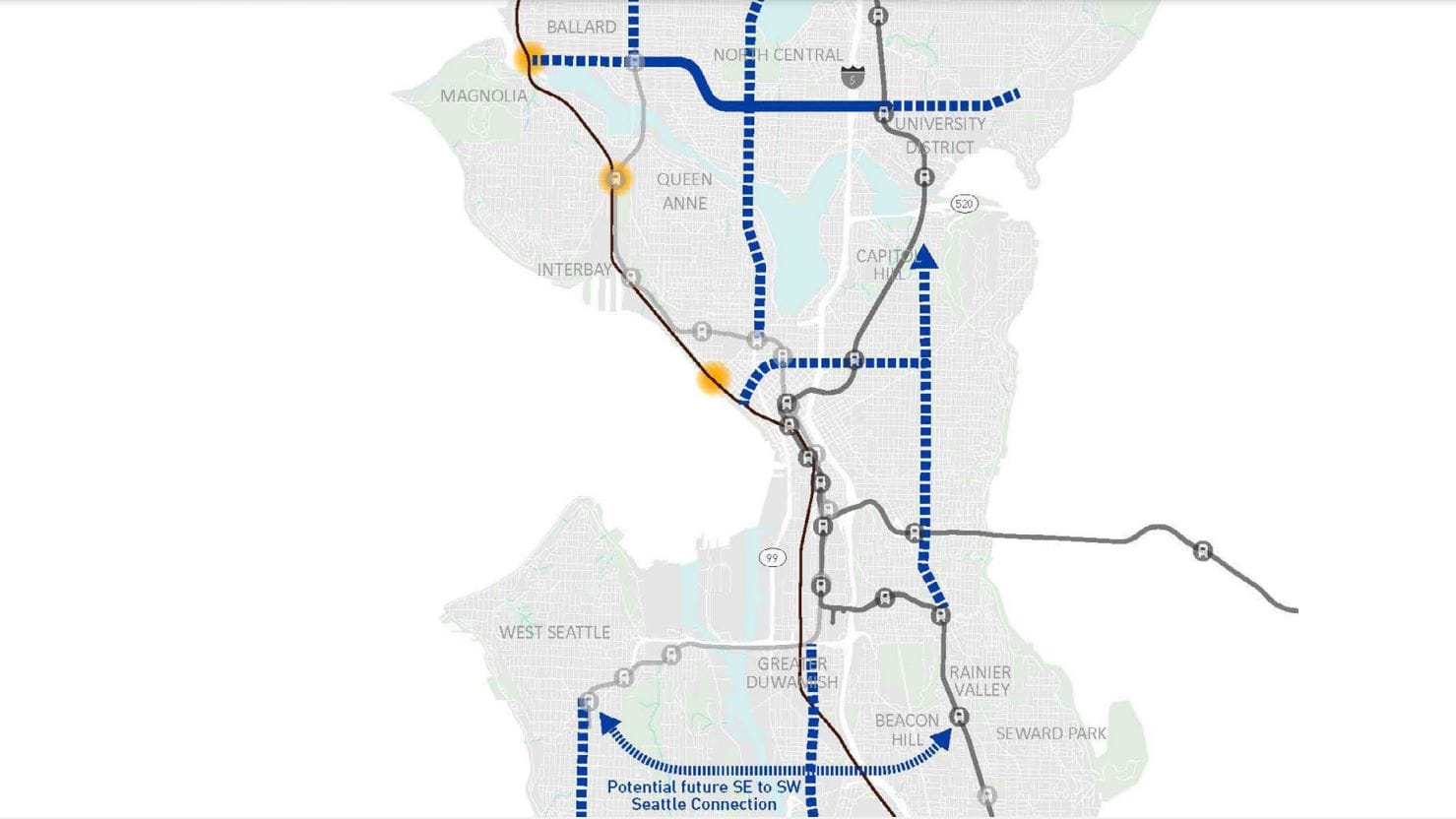
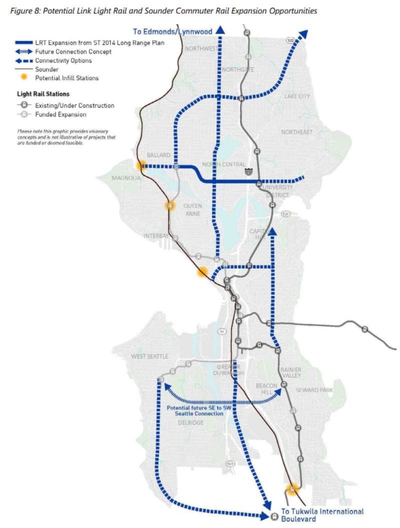
With the update to the City’s long-range transit plan, the Seattle Department of Transportation has taken a leap forward, envisioning more light rail extensions and new lines on top of the Ballard Link and West Seattle Link lines and the in-fill stations already coming with ST3.
Check out Ryan Packer’s primer for a broader look at what’s in the Seattle Transportation Plan, from pedestrianization to bike upgrades and beyond.
The long-range rapid transit vision would establish new crosstown service and fill extend the new lines in the ST3 network farther out from the core of Seattle. Many of these ideas come from Seattle Subway maps and from rail proposals of long ago, with some similarities to the Bogue Plan from the early 1900s and considerable overlap with the Forward Thrust proposals from the 1960s. Neither of those plans came to fruition at the time, but Sound Transit 3 is finally realizing the dream of a network of high capacity rail lines.
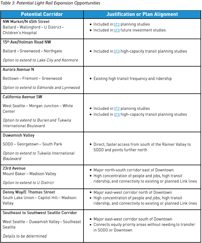
The long-range plan would take that a step further. Here are the lines envisioned in SDOT’s new map.
- West Seattle to Burien would extend West Seattle Link south through Burien and onto Tukwila International Boulevard Station, just one stop before SeaTac Airport on today’s 1 Line. Seattle Subway’s Red Line does the same and continues to Renton.
- Ballard to Lake City would extend Ballard Link north to Greenwood and hook east to junction with Aurora and then Northgate Station before continuing to Lake City. This is Seattle Subway’s Green Line.
- The Aurora Line extends north from South Lake Union Station (coming with the Ballard Link extension) and picks up neighborhoods like Fremont, Wallingford, Licton Springs, and Bitter Lake along the way. This is Seattle Subway’s Pink Line, a focal point of the group’s 2019 map.
- Ballard to U District Line would stretch from the Ballard Locks to the vicinity of Children’s Hospital in Laurelhurst, providing high quality crosstown service, a rarity in Seattle. This was a proposal for ST3 that was left on the cutting room floor in favor of the line from Ballard to Downtown. It is Seattle Subway’s Purple Line.
- West Seattle to Columbia City is included in the vision map and labeled as a possible future connection between West Seattle and Southeast Seattle. This crosstown line goes beyond anything proposed in the latest Seattle Subway maps. The challenge with the route is the dearth of residential density between West Seattle and Columbia City, but, with the potential to connect Georgetown and Beacon Hill along the way and provide an emission-free transportation option in a polluted area, it’s an intriguing idea.
- Denny and Central Area Line would stretch from the Seattle Waterfront through Belltown before connecting with Ballard Link’s Denny Station and continuing east to Capitol Hill and the Central District in the Denny Way corridor. It intersects with another rail corridor envisioned (roughly speaking) along Route 48 on 23rd Avenue E. This is Seattle Subway’s Gold Line. It’s not clear if the SDOT’s vision is for the line to turn south toward Mount Baker or for the Mount Baker to Montlake corridor to be a separate line, potentially using existing tracks in the Rainier Valley to connect the Central District with the whole Rainier Valley. Plenty of time to figure that out!
- Airport Bypass Line would extend from SoDo to Tukwila International Boulevard Station via the direct route in the SR 99 corridor. This is a largely industrial area without much residential density but it would decrease times to the airport and beyond significantly.
- Infill Sounder rail stations are indicated as options near Expedia’s campus on the waterfront, in Interbay, and near the Ballard Locks. Stephen Fesler proposed just such an idea in a 2018 Urbanist op-ed. This would upgrade Sounder North commuter rail service between Seattle and Everett. Infill stations are also envisioned in Georgetown and Boeing Access Road.

If completed, this ambitious rapid transit network that would be arguably the finest in the country, perhaps outside of New York City. It would ensure nearly every major population center in the city had access to the rapid transit network.
Seattle Subway today sent a letter to SDOT, co-signed by The Urbanist and Robert Cruickshank (the chair of Sierra Club Seattle), commending them for their work on the long-range rail map and requesting these three changes:
- Identify West Seattle to Burien as a ST4 project as far as Seattle city limits as noted in the 2014 plan.
- Add Madison Street as a future light rail corridor. This would tie First Hill into the light rail network and provide for the eventual upgrade of Madison RapidRide G Line to light rail.
- Extend the Ballard to Children’s line to Sand Point. This would also prepare the line to potentially extend to Kirkland under Lake Washington.
Seattle Subway has created a letter-writing tool through Action Network to aid in sending comment letters to SDOT and City of Seattle leaders.
The Seattle Transportation Plan is SDOT’s section of the Comprehensive Plan update due to be finalized next year. The Comp Plan update will have a huge impact on zoning and the city’s housing growth strategy, as well. These are big decisions that could reverberate for centuries. It’s great to see Seattle grappling with how it can meet the needs of generations well into the future.
Seattle Transportation Plan Shows an Ambitious Vision, But the Hard Part Comes Next
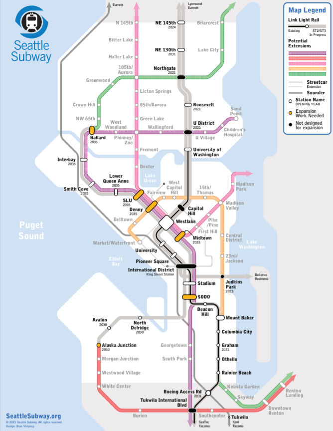
Seattle Subway’s 2021 Map Upgrades Light Rail Connections in Renton, Lynnwood, and Kirkland