The Puget Sound Regional Council (PSRC) delivered an update on the Regional Aviation Baseline Study last week. The added findings affirm earlier analysis that unconstrained growth in commercial passenger and freight aviation in the Central Puget Sound would require at least one additional major airport on the scale of Sea-Tac International Airport. It bears underscoring that unconstrained growth in this context means long-term demand for aviation capacity if it were unconstrained by other parameters (e.g., airport facilities, airspaces, hours of operation, and landside access).
The study, however, is not meant to determine where and when additional airport facilities should be added in the region or to redesignate airports. Instead, it is meant to take stock of what already exists and what is planned in the future to understand what potential needs will be or policies should be established in the years ahead. A separate planning process commissioned by the Washington State Legislature is just getting underway to suss out where another major airport should go in the state, which may use information being gathered through the Regional Aviation Baseline Study.
Several PSRC Executive Boardmembers pushed back on the study process raising concerns about an abstract unconstrained growth model. King County Council and PSRC Executive Board member Claudia Balducci (Council District 6-Bellevue) spoke to this frankly. “There’s a missing level of planning, somewhere between the state and the region and the cities; maybe it’s the feds,” she said. “We do this thing where we project what we call unconstrained growth, but I’m not sure if it’s really unconstrained. I think there are certain embedded assumptions in there that become privileged assumptions that we don’t examine.”
Councilmember Balducci continued saying, “we don’t embed assumptions about externalities about the growth, and so we are always disadvantaged when it comes to policy.” She pointed out that conversations surrounding numbers often become an exercise in determining how to meet them instead of whether or not they “ought” to be met or met at what level. In concluding her remarks, she said, “the constraint doesn’t ever seem to be: ‘Well should we? Is this the kind of community we want? Is this the kind of transportation we want to encourage?'” Major aviation facilities are known for significant noise pollution, very high carbon emissions, local ground transportation congestion, and other localized and regional environmental impacts, which often disproportionately affect lower-income people and people of color.
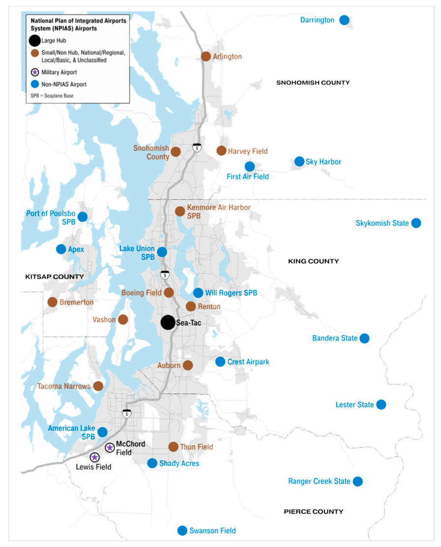
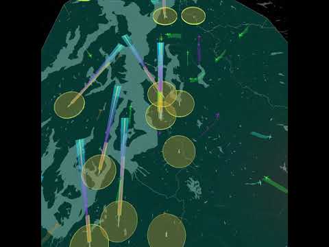
PSRC staff shared several graphics layering the complexity of regional airspace, which is the product of having 29 different airports. Sea-Tac International Airport, of course, is the most significant. However, there are two military airports are located in Pierce County, five seaplane bases are scattered across the four-county region, and another 21 small, regional, and recreational airports.
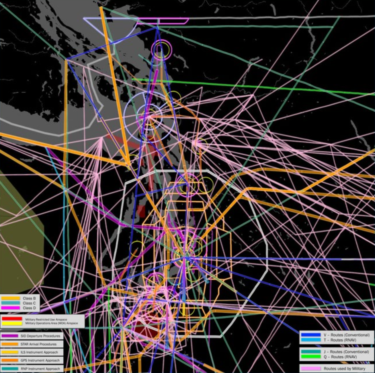
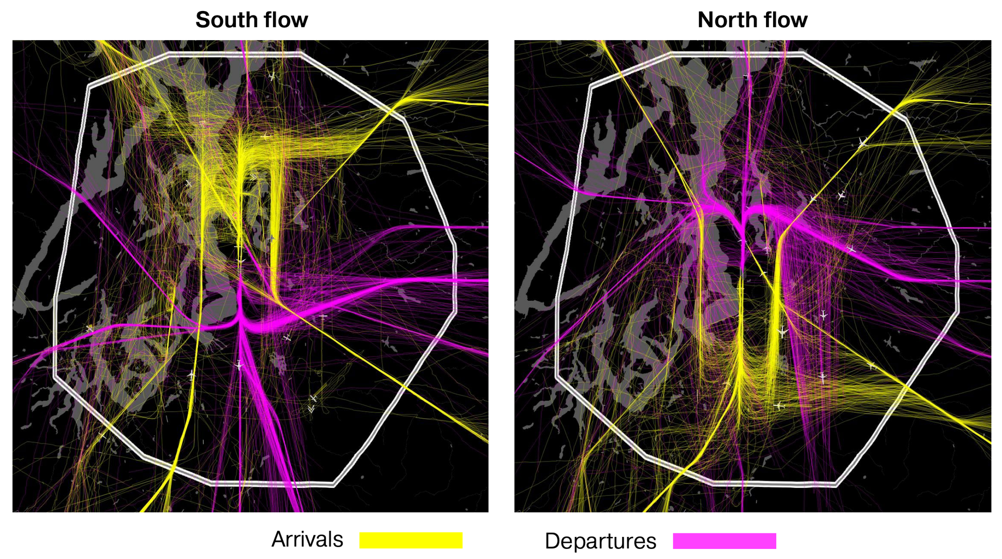
For commercial passenger and freight activities, Snohomish County Airport (Paine Field), King County International Airport (Boeing Field), and Renton Municipal Airport are the most active and heavy airports besides Sea-Tac International Airport. All three of them permit aircraft on the scale of at least Boeing 737s, which require higher levels of navigation equipment and more airspace to maneuver. Much of that airspace directly overlaps, which means that aircraft movements have to be fairly tight and dictates the flightpaths for takeoffs and landings.
Staff highlighted one example of a tight flightpath. Planes arriving at Renton Municipal Airport must descend over Mercer Island and then proceed south toward Downtown Renton before beginning to veer slightly east upon approaching the shoreline of Lake Washington at Renton. Just before aircraft reach the upland area southeast of the I-405/SR-167 interchange, pilots must bank very tightly to north to complete the final approach and land.
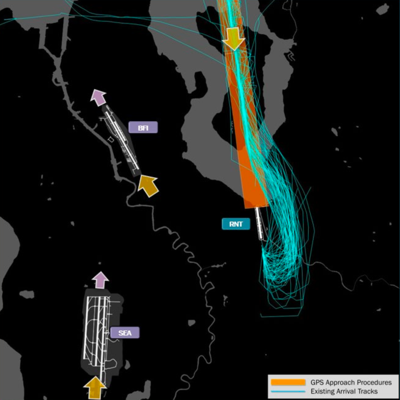
This delicate dance is to avoid other flightpaths and topography that limits aircraft movements throughout hilly and mountainous metropolitan area. PSRC staff empahsized that the Puget Sound Region has one of the most constrained and complex airspaces in the country. Other top contenders include the Bay Area and New York City.
Looking at Sea-Tac International Airport, it is easy to see that the flightpaths from the ground are very linear and tight as aircraft move over Seattle and Southwest King County. Current protocols from the Federal Aviation Administration (FAA) are prescriptive on how aircraft enter and exit regional airspace as well as queue within it.
In the years ahead, the FAA’s national airspace modernization program, NextGen, should provide future efficiencies in airspace management and aircraft movements. It would allow more seamless flightpaths and allow closer movements between aircraft. This ultimately translates to higher airspace capacity and provides the potential for more takeoffs and landings.
However, the unconstrained growth forecasts for the region indicate that commercial passenger service will reach capacity pain points in the next several years. Total passenger enplanements are slated to balloon to 55.6 million by 2050, more than doubling from 2017. The enplanement metric is only how many passengers board planes, not the total number of passengers boarding and disembarking commercial aircraft.
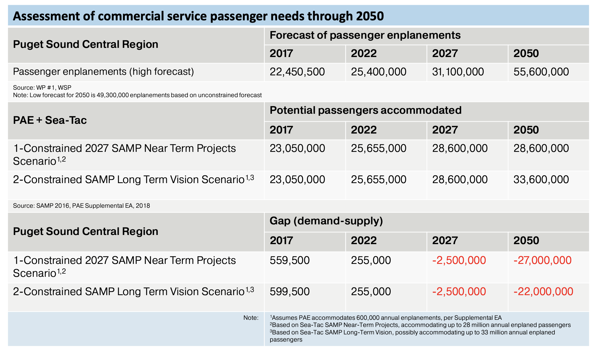
By 2027, regional capacity for commercial passenger service may fall behind. Analysis be the PSRC indicates that 31.1 million enplanements are forecasted that year, but only 28.6 million enplanements will be able to be accommodated with existing and planned facilities at Sea-Tac International Airport and Snohomish County Airport (PAE)–the latter of which is capped at 600,000 annual enplanements for now. Based upon near-term planned actions under the Sustainable Airport Master Plan (SAMP) to expand landside capacity (e.g., gate facilities) and airfield improvements at Sea-Tac International Airport, a capacity deficit of 2.5 million enplanements is project in 2027.
The deficit is projected to grow through 2050, even with the long-term SAMP being realized. Somewhere between 22 million and 27 million enplanements is the deficit projected, depending upon project improvement delivery at Sea-Tac International Airport. A graphic highlighting the increase in gate capacity at Sea-Tac International Airport illustrates the problem:
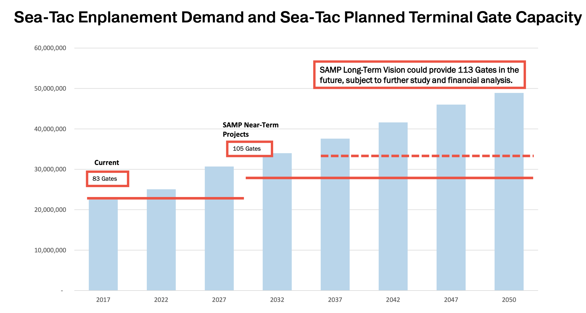
With SAMP near-term projects, the number of gates will rise from 83 to 105 by 2032. An extra eight gates could open by 2037. However, the pace of gate deployment is anticipated to lag behind demand. The new Concourse D annex where passengers are bused to and from hardstands on the tarmac illustrates this conundrum.
Another function of the capacity problem is use of the airfield. As the number of operations increase on the tarmac and runways, delays to individual flights on the ground increase. Potential for increased airfield capacity at Sea-Tac International Airport remains fairly limited given the topographic and space limitations for expansion of aprons, taxiways, end-around taxiways, and runways.
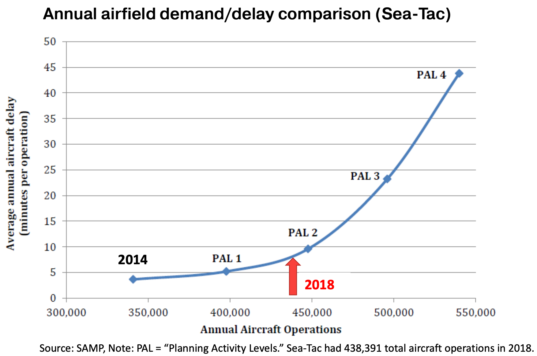
Last year, operations on the airfield reached 438,391. Increased operations beyond this point could spike from about eight minutes of delay to 10, 15, or even 45 minutes on a nearly exponential rate as aircraft operations approach 550,000 per year.
In evaluating landside constraints and access to Sea-Tac International Airport for the planning period to 2050, the PSRC looked at how many people can reasonably reach the airport within one hour. About 62% of the four-county region’s residents (2.5 million) fell within a one-hour’s distance of the airport. Most people south of Tacoma and Puyallup, north of Shoreline and Kirkland, and east of the urban areas of East and Southeast King County fell outside of that travel time distance. No one from Kitsap can reach the airport within an hour.
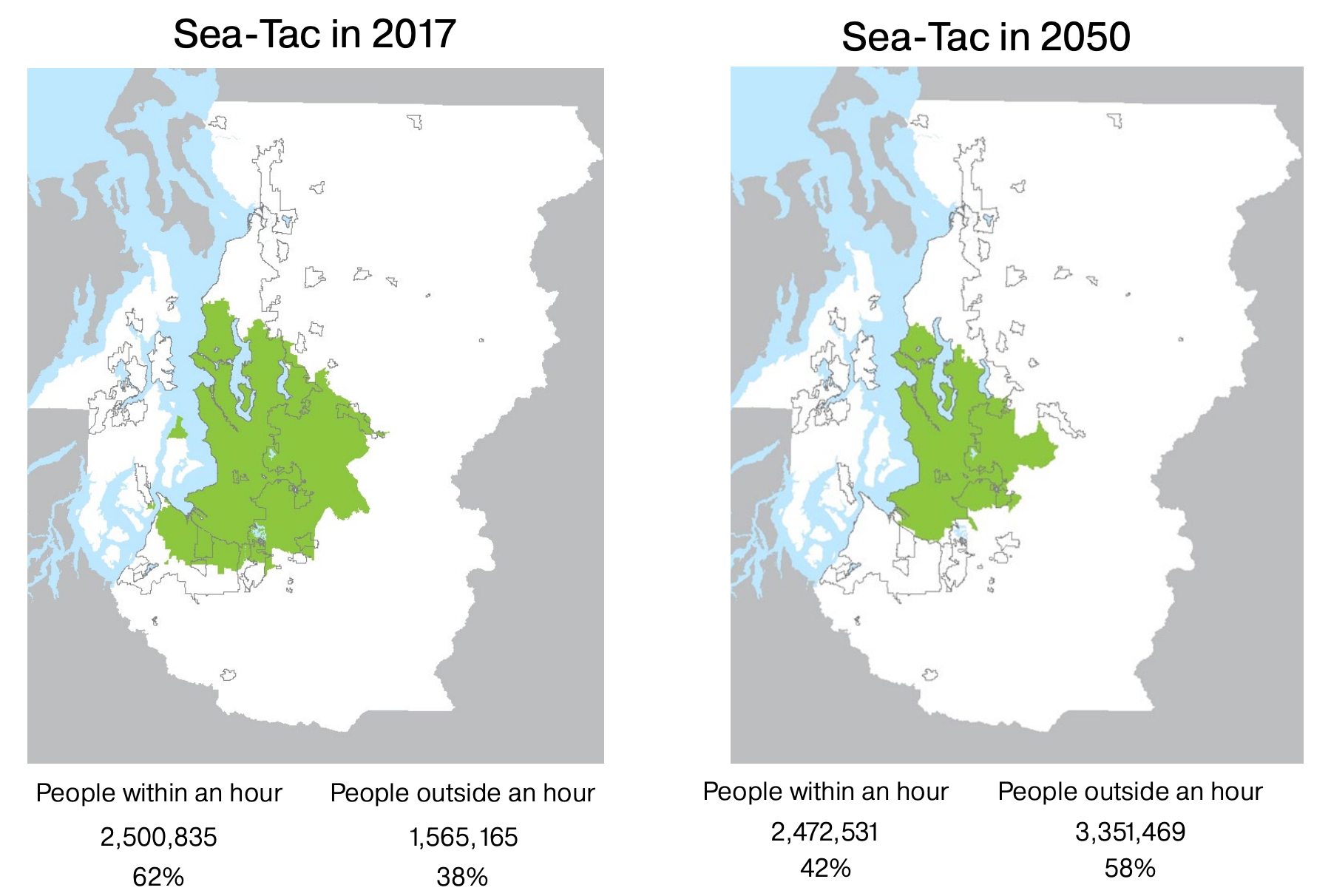
By 2050, the share of people capable of reaching Sea-Tac International Airport within the four-county region is projected to fall even further to 42%, but that is still about 2.5 million residents due to population growth around Seattle. The one-hour time travel distance is expected to contract significantly inward toward the airport.
However, when combining the one-hour travel time distance with Snohomish County Airport (PAE), the numbers look quite a bit better for access. About 83% of the four-county region’s residents (3.4 million) are within a one-hour travel distance to one or both airports, the PSRC reported.
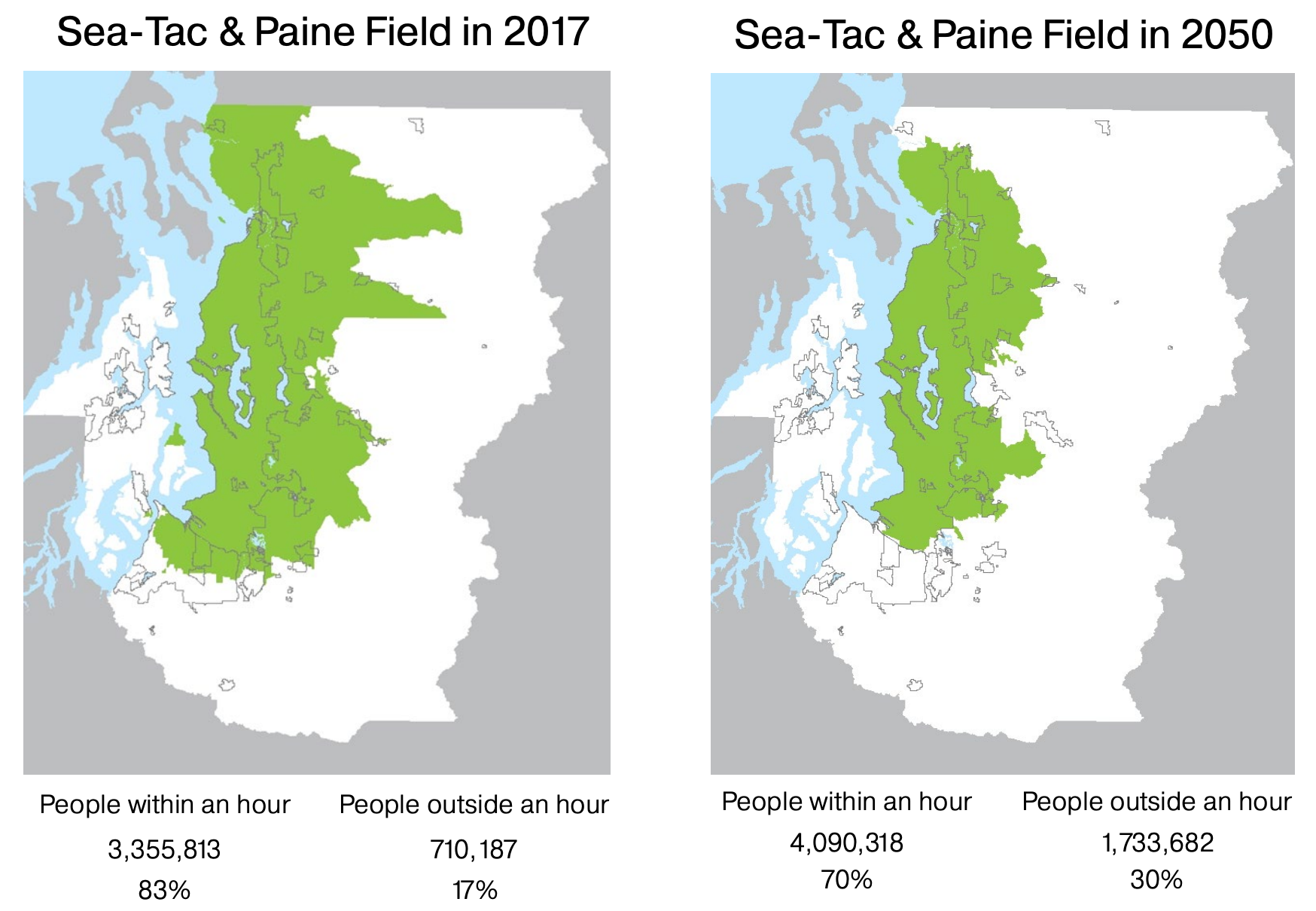
However, that number falls to about 70% of the four-county region’s residents (4.1 million) by 2050. Under either scenario, people in the southend, including Tacoma and Puyallup, lose access to Sea-Tac International Airport within an hour by 2050.
Using King County International Airport for mainline commercial passenger service has routinely been proposed as a way to provide an alternative facility and relief. In the mid-2000s, there was a short-lived effort to bring mainline commercial passenger service to the airport, but it never became a reality after being rejected by then-King County Executive Ron Sims. The existing airspace and landside conditions are highly constrained, which means bringing mainline commercial passenger service to the airport now would be a very challenging endeavor with little opportunity for future expansion. It also would do little for people who live in the southend of the region–some of whom already deal with the noise and pollution of being near a major airport.
The next phase of the Regional Aviation Baseline Study will involve deeper analysis of airspace flow, future landside and airside capacity needs, and future needs by aviation type and airport. A final report is due next summer summarizing findings and recommended next steps.