Redlining Reimagined: Racist maps that banks used to deny mortgages to communities of color have a long legacy.
Seattle is one of the fastest-growing cities in the nation, fueled in large part by its booming tech sector. While this growth has caused housing prices to surge with increased demand across the city, not all communities are being impacted equally. To understand why some neighborhoods are disproportionately vulnerable to modern pressures like gentrification and displacement, we must look into the past to the practices that deliberately set up this inequality.
From the very beginning, Seattle was exclusionary, being founded with legislation that expelled the native Duwamish people and prevented them from residing within city limits. These segregationist roots persisted throughout the decades, with many explicit anti-Asian and anti-Black policies being enacted in the 19th and 20th centuries. One of the specific practices of this discrimination was redlining, an incredibly influential form of housing discrimination that prevented certain communities from being able to access home loans or often other forms of equity like small business loans.
The term redlining is often applied broadly to describe various forms of housing discrimination; the term, however, comes from a specific practice orchestrated by the Home Owners’ Loan Corporation (HOLC). This federal agency was established by President Franklin Delano Roosevelt, along with the Federal Housing Administration (FHA), both in an effort to expand homeownership and make it more accessible for Americans.
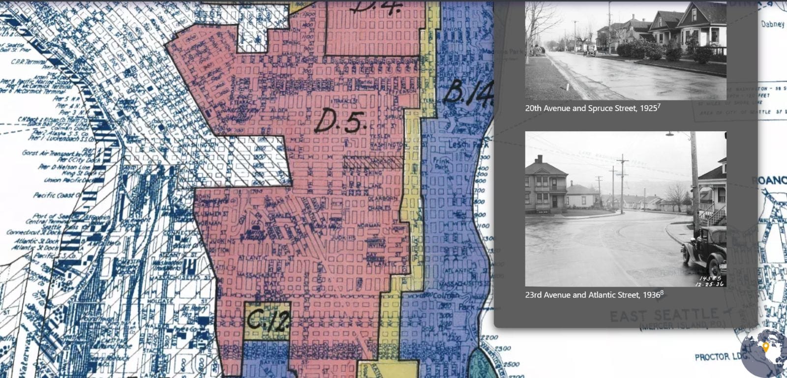
As part of this effort, HOLC developed “Residential Security” maps of every major American city. The idea was that these maps would assess the riskiness of granting home loans in different neighborhoods, with areas ranked from Grade A (Green/ “Best”) to Grade D (Red/ “Hazardous”).
Despite supposedly being about economic stability, racial demographics were undeniably a major component in which classification a neighborhood received. White neighborhoods were typically classified as “Best”, but if even one Black family lived there, the neighborhood would be determined to be “Definitely Declining” or “Hazardous”.
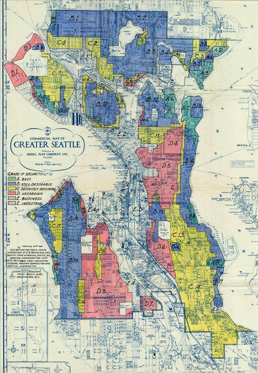
This trend is evident when reviewing the area descriptions that accompanied the HOLC grades. White neighborhoods, such as Laurelhurst or Queen Anne, had long and detailed descriptions of the neighborhood and houses to justify their higher grades. Compare this to non-White neighborhoods, such as the Central District, where the entire area description was reduced to a single sentence: “This is a negro area of Seattle.”
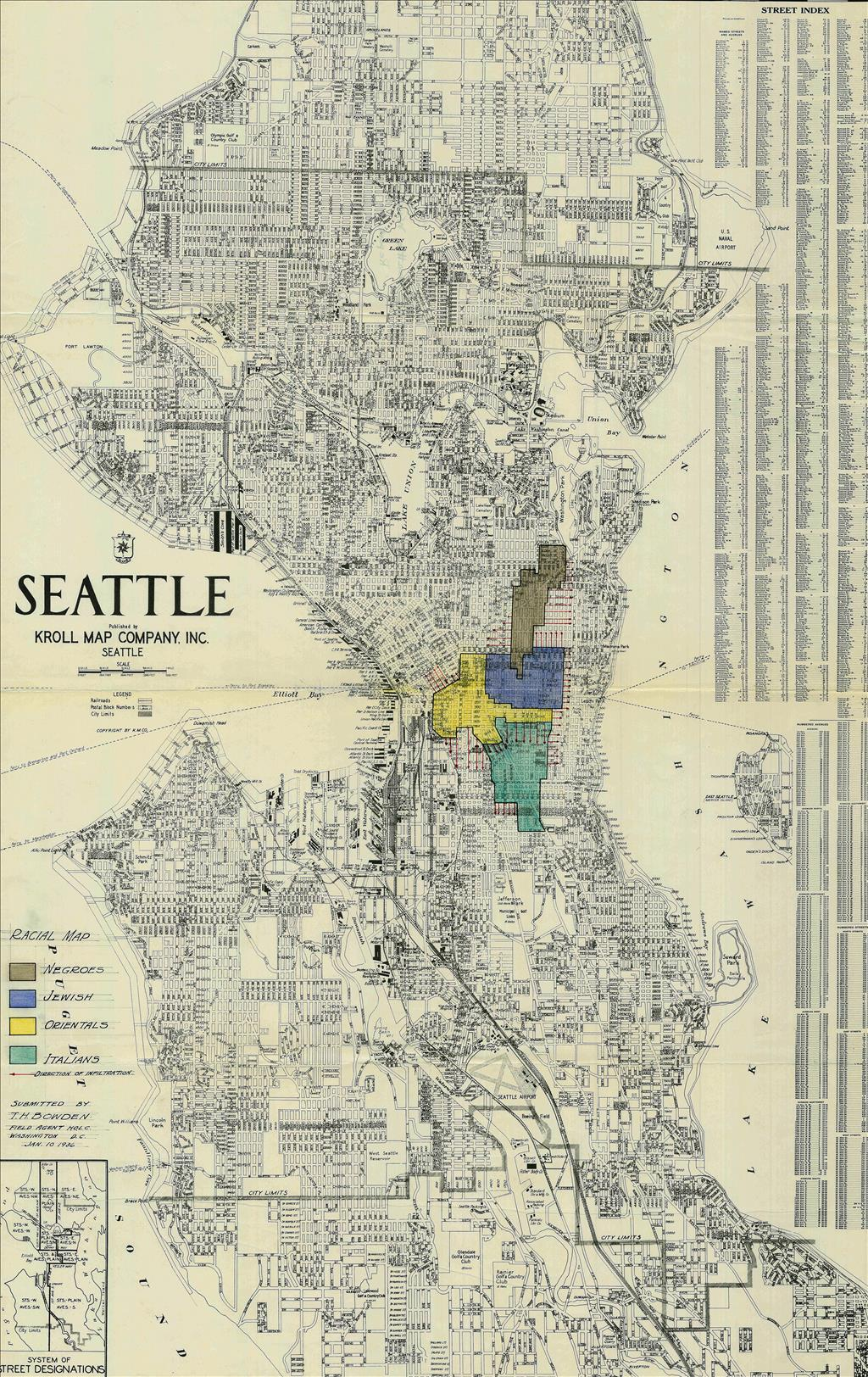
Another piece of evidence of the racist nature of this practice is the HOLC “Racial Map” of Seattle. This map was created on the same day and by the same people as the redlining map, and showed the exact neighborhoods that marginalized racial groups lived in. The “Racial Map” also had arrows showing the “direction of infiltration” of these groups into White neighborhoods. Aside from being extremely disturbing, this map further demonstrates that race was undoubtedly a major component of the residential grades.
Despite the Fair Housing Act of 1968 outlawing the practice of redlining across the United States more than 50 years ago, the classifications neighborhoods received on the 1936 HOLC redlining map are still impacting communities across Seattle to this day. That is because after they were created, they were adopted by the FHA and private banks who used the map to inform decisions on whom to lend to.
Those in the C and D graded areas were systematically denied home loans, or in the rare instance that they were able to secure a loan, received highly unfavorable conditions on them. Not being able to access loans prevented families and individuals in redlined areas from building generational wealth in the form of home equity. This created severe wealth gaps that still persist today.
An ECONorthwest study found that without racially discriminatory housing practices (including redlining, in addition to practices such as racially restrictive housing covenants and private sector discrimination), Black, Indigenous, people of color (BIPOC) households in King County would hold between $12 billion and $34 billion in additional wealth today.
In addition to severe wealth disparity, redlining also caused a crisis of disinvestment in redlined neighborhoods. In 1975, the Central Seattle Community Council Federation wrote a report titled Redlining and Disinvestment in Central Seattle, where they define disinvestment as “a general policy followed by banks of taking in savings deposits from residents of a redlined area but refusing to return that money, in the form of home, business, and consumer loans, to the community that provided the money.”
Instead of the money individuals deposited into banks supporting their own community, it would be funneled out to support the wealthy suburbs outside of Seattle. The report found that in the Central District, a historically Black neighborhood, for every $1 that residents deposited into local banks, only 25 cents would be returned to the area, with none of that money being seen in redlined areas of the district.
Meanwhile, in the suburbs, for every $1 deposited, $2 would be reinvested back into their community.
This practice of disinvestment is an equally important component of the legacy of redlining as wealth inequality is, as disinvestment turned redlining into a self-fulfilling prophecy. By denying access to loans and reinvestment, banks caused redlined neighborhoods to physically and economically deteriorate. This issue is larger than just economics. Disinvestment has had many long-term effects on formerly redlined Seattle neighborhoods, impacting everything from educational and job opportunities to long-term health outcomes. These consequences play a major role in the continued inequality within Seattle.
Redlining and the disinvestment it caused are inextricably linked to our modern housing crisis. These practices starved communities of capital for decades, which effectively “devalued” the land, causing them to be vulnerable to modern housing challenges such as gentrification and displacement. The tragic irony is that the same communities once restricted to these neighborhoods by discriminatory policy are now being forced out of them by modern market pressures.
Understanding the history and legacy of redlining is essential to understanding uneven growth pressure on Seattle’s neighborhoods today. Despite its importance, redlining is often left out of educational curricula, or if it is covered, it is done so in a way that is not engaging, which prevents students from truly grasping the impact it has had on their city.
To bridge this gap, I developed an interactive educational website that explores the history and legacy of redlining in Seattle. The site is centered around a StoryMap narrative that walks users through the story of redlining in Seattle, with specific examples of how different neighborhoods have been impacted. The site also has an interactive comparison map, where users can compare the historic redlining map with modern data on inequality in Seattle.
Of course, it is important to recognize that HOLC redlining is only one example of housing discrimination in Seattle. Many other practices such as racial covenants, restrictive zoning regulations, plowing freeways through BIPOC communities, and discrimination by real estate professionals, should be considered when discussing housing inequality. So too should modern problems, such as efforts by wealthy elites to block affordable housing initiatives.
While the problem is multi-faceted, the visual nature of the HOLC maps provide an intuitive way to quickly understand aspects of how housing discrimination has impacted one's own city. Understanding the connections between historic discriminatory practices and modern day inequality reveals how deeply systemic and persistent these issues are. It also gives us the power to challenge them and push for better solutions to Seattle’s housing crisis.
Explore the Redlining Reimagined project to learn more about redlining in Seattle and its relation to inequality today. (For the best experience, viewing on a desktop is highly recommended.)