A Salvation Army homeless shelter in SoDo on the edge of Chinatown is where Sound Transit is considering siting a light rail station. (Doug Trumm)

It ain’t much, but that’s all the Board’s going on too.

This week, the Sound Transit Board of Directors will be deciding on preferred Ballard Link alignments and station locations. Some are still up-in-air, with the most critical ones in the Midtown-to-I-90 segment. Impacts to the Chinatown International District (CID) have emerged as primary concerns.

In response, the agency whipped up two alternative station locations in the eleventh hour that have only preliminary, unvetted studies, but could suddenly find themselves in the Environmental Impact Statement (EIS) that is the next step before seeking federal approvals and local building permits.

Selecting those late-emerging options would mean delaying the EIS in order to conduct further study on the new alternatives to bring them on par with the other options Sound Transit has been studying for years and that had been included in the 8,000-page Draft EIS released last January.

Let’s take a closer look at each of the options still in contention. Jump to:

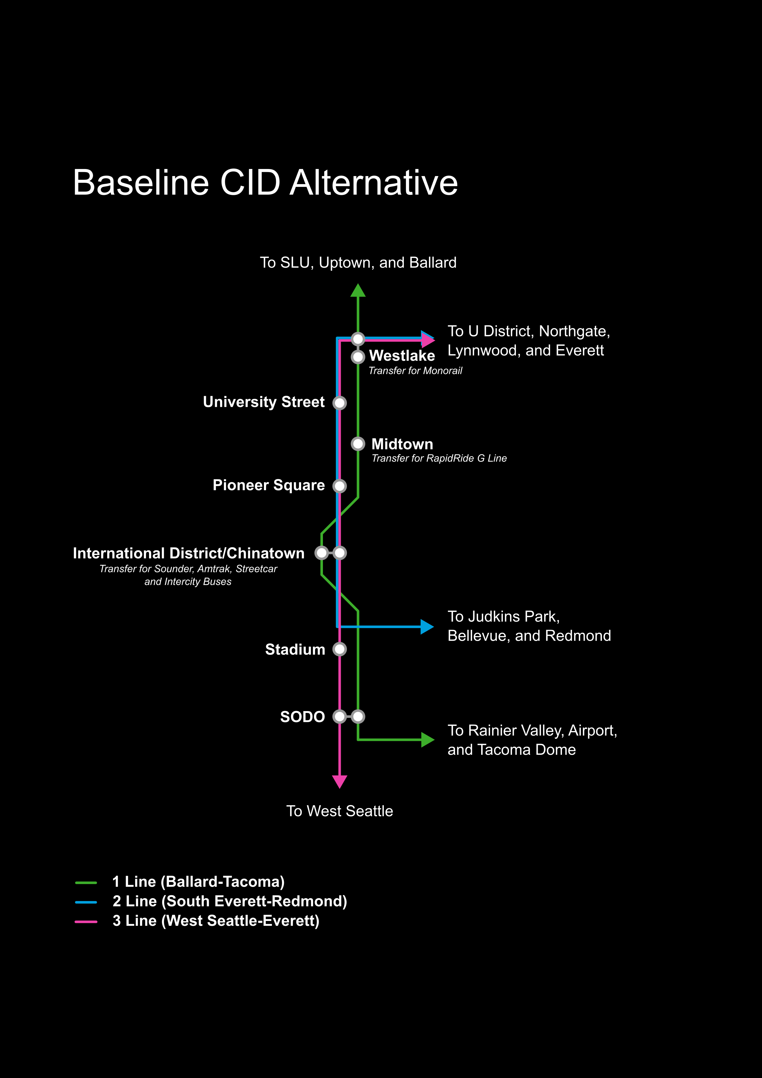
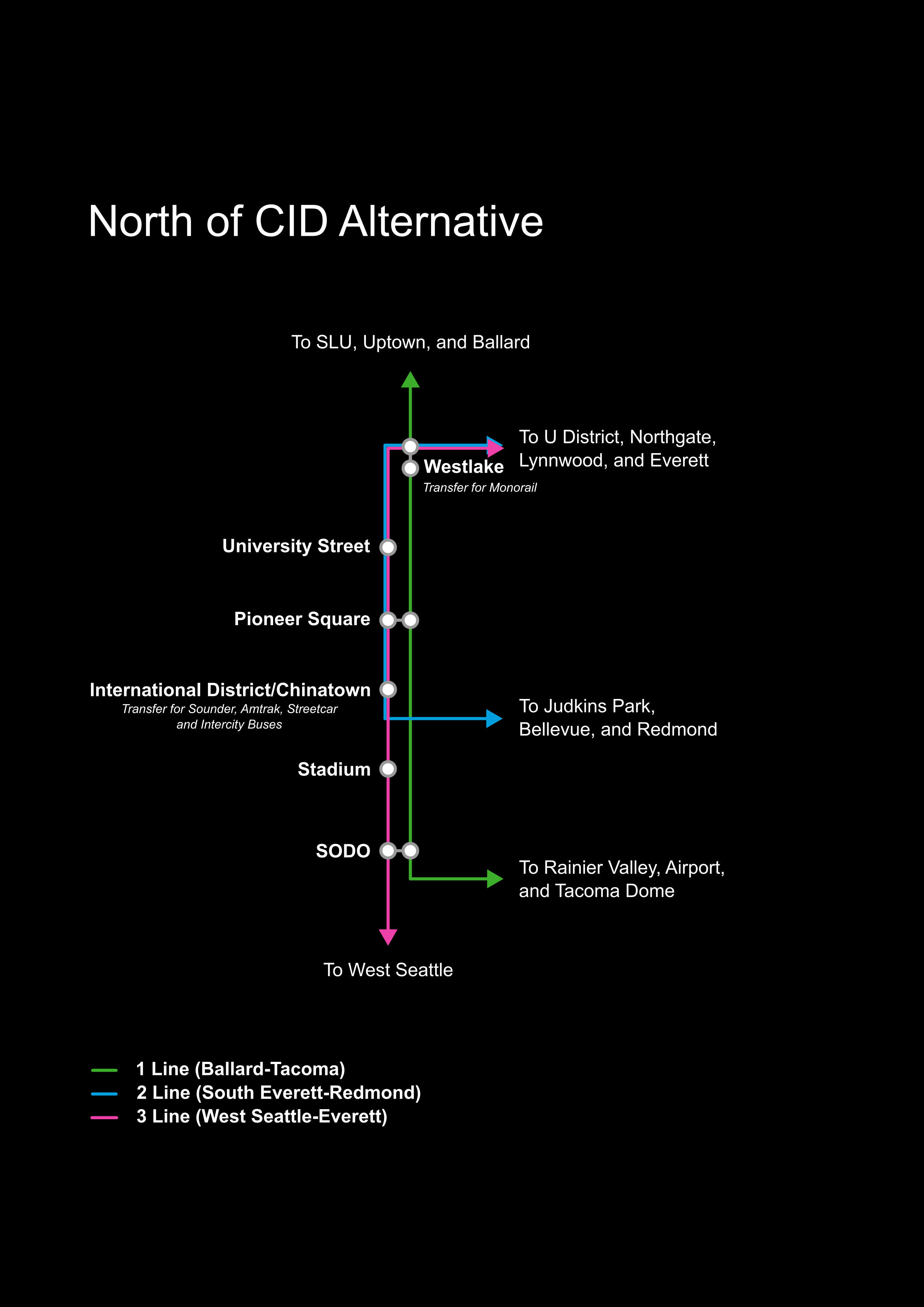
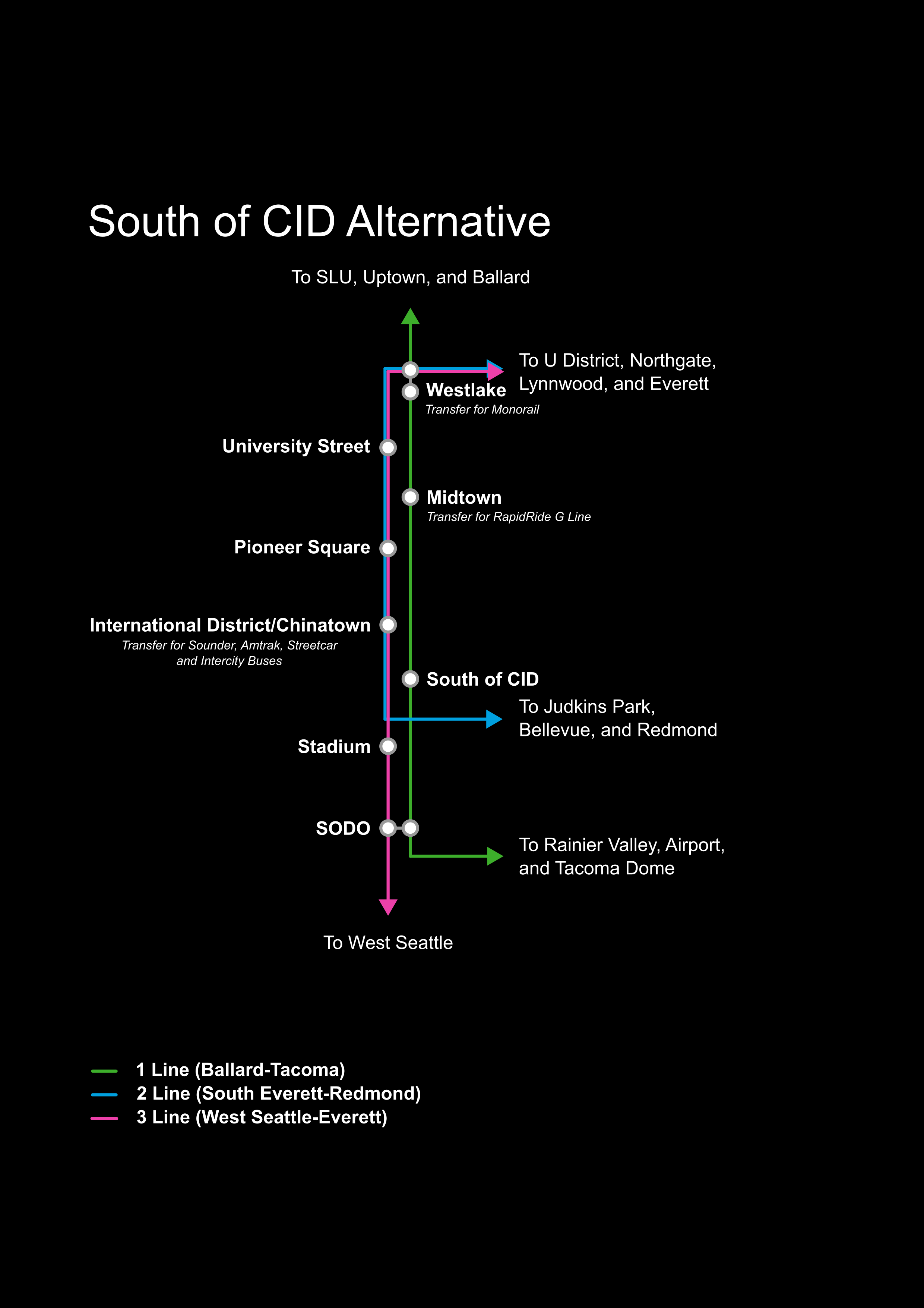
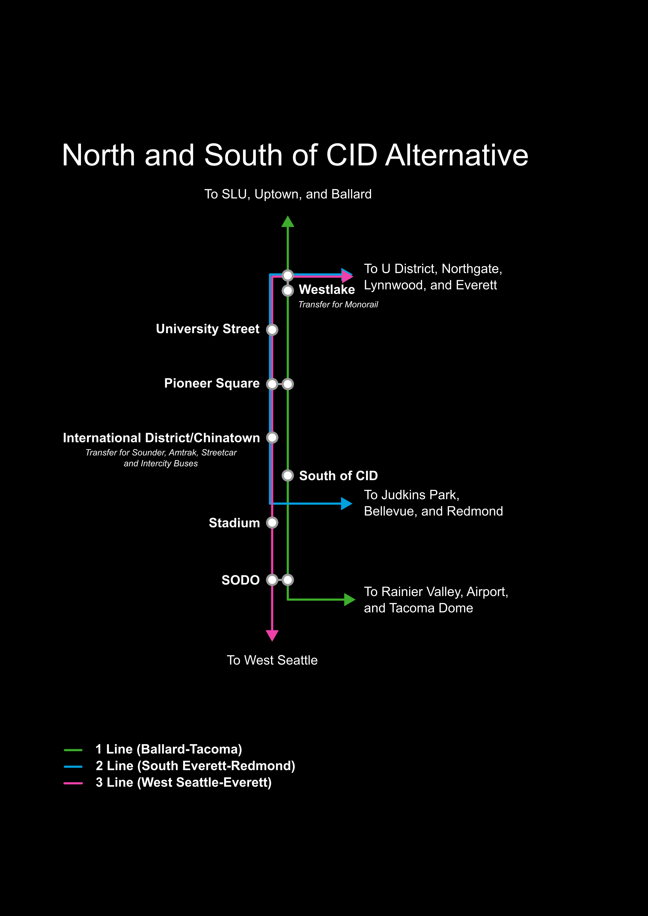
The 4th Avenue options place the station at Union Station, on the opposite side of the building from the existing Chinatown-International District Station. It pairs with a new downtown tunnel and a Midtown Station at approximately 4th Avenue and Madison Street across from the Central Library. In the alternatives, the South of CID station will be on the large site south of Seattle Boulevard and 6th Avenue, and the North of CID station will be at James Street and 4th Avenue, the site of the County Administration Building. In the proposed “North and South of CID” option, those two stations are paired together with a tunnel under the CID. In all cases, the North of CID station precludes the 4th Avenue and Midtown stations.  

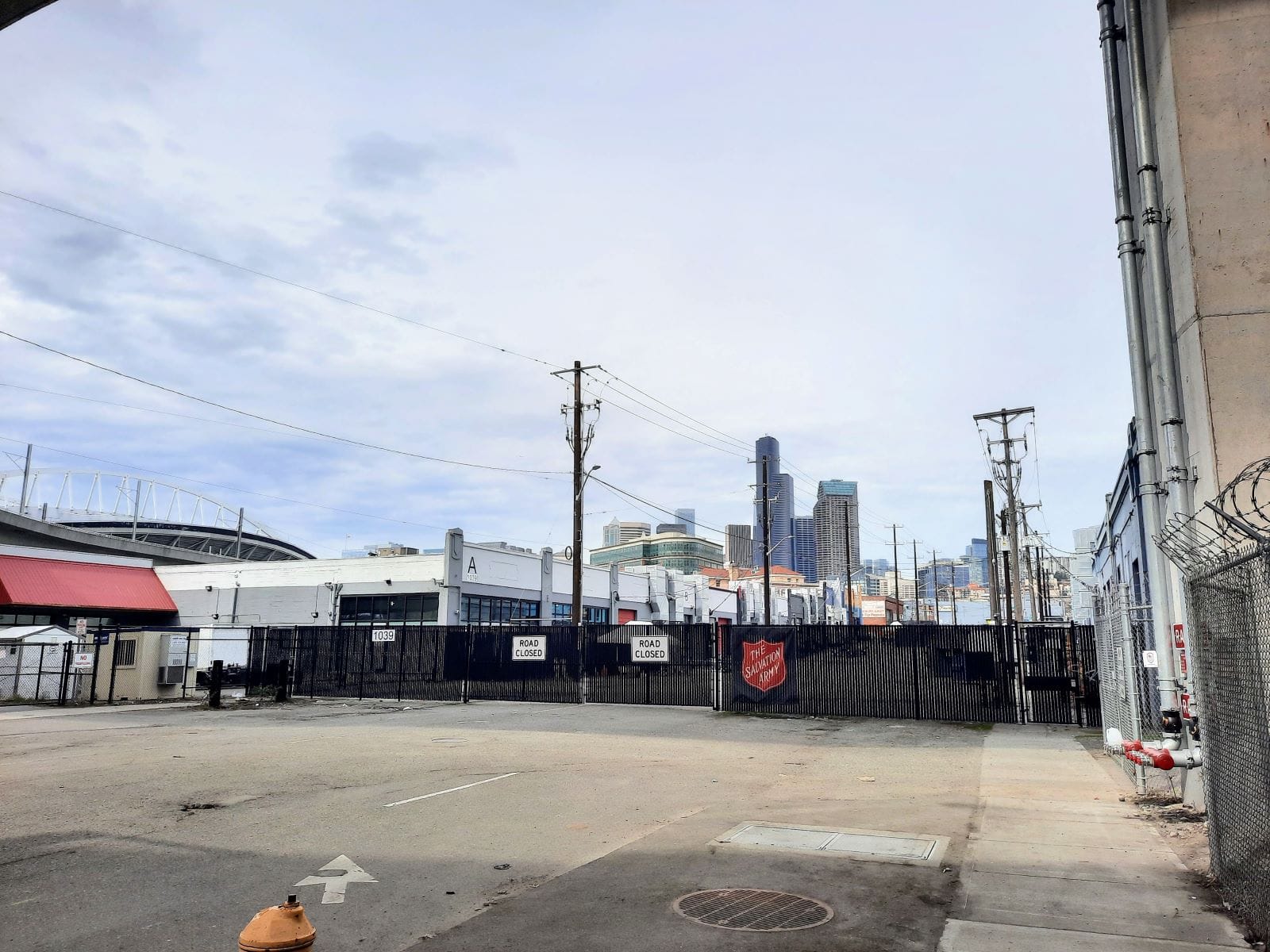
South of CID dumps riders at a web of highways.

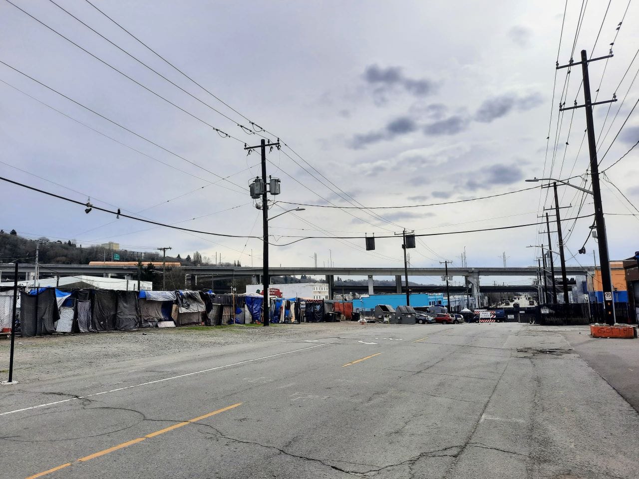
There’s been little conversation about the South of CID station location that Sound Transit has pitched, but it’s important to understand its context. The agency is contemplating building it about 95 feet to 115 feet underground immediately under 6th Avenue S a few blocks to the south of Uwajimaya Asian Market.

Just south of the proposed station location in the South of CID options is a tangle of I-90 flyover ramps. (Doug Trumm)

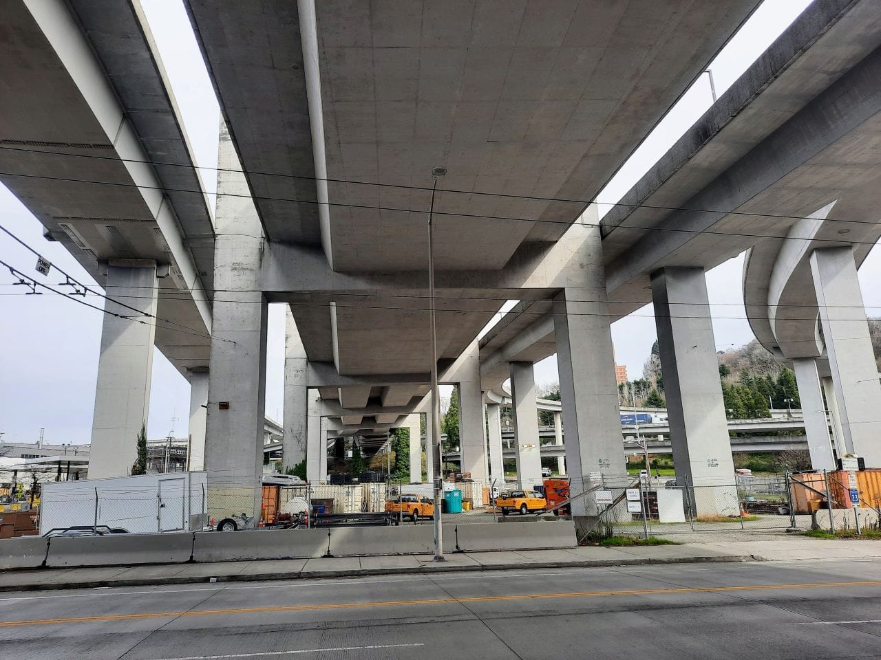
The north end of the platforms would be approximately at S Plummer Street and stretch south toward the I-90 ramps. The baseline station concept also envisions only two headhouses at either end of the platforms.

Designs for the South of CID station would require CID-bound riders cross busy Seattle Boulevard S, a freight route that carried 12,000 daily vehicles at last count. (Sound Transit)

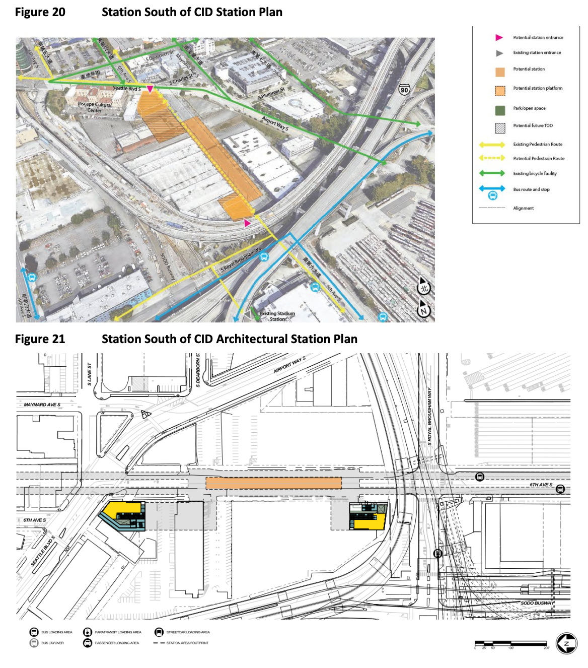
The fate of the area is uncertain. Right now, about a dozen buildings and a portion of 6th Avenue S serve as an emergency shelter site for about 400 people experiencing homelessness. Other than the Inscape Arts and Cultural Center to the northwest and a handful of buildings north of S Charles Street, the immediate area is full of surface parking and abandoned buildings. It is bounded by a web of I-90 and East Link flyover bridges and a BMW car dealership. Things might change though and that could affect how a station would be constructed and if equitable transit-oriented development could even be realized.

Most people will walk to the CID Station according to agency projections, but transit transfers are a close second. (Sound Transit)

Urban Visions, one of the largest development firms in Seattle, has hefty landholdings in the area with several speculative plans in the works. Founder and CEO Greg Smith traces its lineage to one of the earliest mayors of Seattle: Leonard P. Smith and his family has had its fingerprints all over downtown Seattle real estate for generations. The younger Smith pumped $20,000 into Seattle’s 2019 municipal election hoping to bolster the corporate-friendly centrist side, with $10,000 going to Tim Burgess’s “People for Seattle” political action committee, Open Secrets records show. Burgess is now a senior official in Mayor Bruce Harrell’s cabinet.

Urban Visions recently filed preliminary plans for a 340-unit residential development at the southwest corner of Seattle Boulevard S and 6th Avenue S and has development entitlements for a major mixed-use project on the remaining lots west of 6th Avenue S and east of 6th Avenue S.

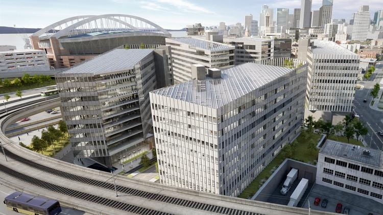
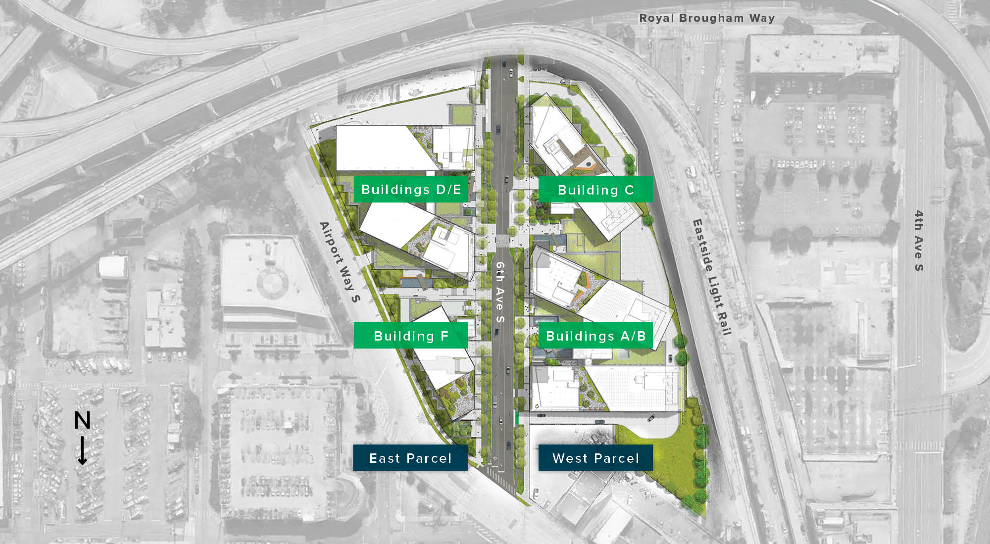
Collectively dubbed “S-Campus,” the development would add 1.25 million square feet of Class A office or laboratory space spread out in six shiny buildings on a nearly seven-acre campus. Valued at over $600 million, none of the planned developments would comport with conceptual headhouses that Sound Transit has sketched out for preferred station entrances. Urban Visions has been working on proposals for that site since 2014 and appeared close to breaking ground in 2020. And then the pandemic happened, office demand tanked, construction costs spiked, and the project was paused.

Urban Visions has not publicly acknowledged the S-Campus project is dead, but they have been maneuvering to buy themselves some time by extending leases to tenants on the property. First, the company negotiated a deal with King County to extend the lease of the 270-bed Salvation Army homeless shelter on the site and clear the way for an expansion. Through the deal, Urban Visions pocketed a tidy sum of $54.3 million for a five-year lease in addition to help paying taxes and upkeep. One-time American Rescue Plan Act dollars were set to pay for the project.

However, the proposal kicked up neighborhood pushback, with some arguing they hadn’t been consulted and that too many homelessness services were being concentrated in the CID as opposed to wealthier, White neighborhoods. This uproar caused King County Executive Dow Constantine to pull out of the deal and say he intended to rededicate the time sensitive funds to other projects. However, a Constantine spokesperson confirmed the County still holds the lease on the S-Campus property.

The S-Campus property is currently being used for a Salvation Army temporary homeless shelter. 6th Avenue S currently dead-ends at the facility rather than providing access through to Royal Brougham Way in SoDo. (Doug Trumm)

In his State of the County speech, Constantine announced his support for a light rail alignment that puts a station on King County Administration Building in the north and the S-Campus site in the south. With the station plan likely requiring that Sound Transit or the County purchase the site rather than just leasing it, Urban Visions again is poised to profit handsomely. With a five-year lease costing $54.3 million, the price to permanently purchase the site is likely to be very expensive, especially given the aforementioned project valuations over $600 million.

Questions about this arrangement remain as the developer, City, and County have so far declined to divulge details, even with the Thursday vote approaching and the success of the option hinging on the deal adding up.

Even if those real estate hurdles are cleared, there are substantial issues with the site. The location does not lend itself as an obvious transfer to the other two light rail lines, Sounder, and most other transit. It is too remote from other stations and surrounded by major roads. Just from the northern station exit, it would take about six minutes to reach the nearest International District/Chinatown Station or King Street Station Sounder entrances without any intersection crossing delays. Riders going to and from the south and wanting to transfer between the 1 and 2 Lines (Ballard-Tacoma Dome and West Seattle-Everett, respectively) would be better off doing that at SoDo Station or North of CID stations than here.

The Weller Street Bridge (just to the left in this photo) is the closest place to cross the railroad tracks and reach King Street Station and the rest of Pioneer Square from the South of CID. (Doug Trumm)

The agency has not proposed any underground passageways of Seattle Boulevard S in its baseline concept, so factoring in crossing times would add several minutes just to the surface walk time. When adding in time to navigate vertical conveyances at the South of CID station and at the Union Station Hub, riders are realistically going to be spending over 10 minutes just to get from platform to platform in the best of circumstances. That arguably may be competitive with some transfer scenarios to the north that riders would be forced to make without another station directly at the Union Station Hub complex, but the environment of the South of CID station is hostile to people walking.

Seattle Boulevard S is a five- to six-lane stroad that even has median and sidewalk Jersey barriers, in part because it is a principal route for freight. Crossing is unavoidable unless the agency adds an underground passageway. Riders will also likely have to cross S Dearborn Street, which is a similar stroad. But there’s still more obstacles because riders have to make their way north and either have to choose a walk up 5th Avenue S or 4th Avenue S to reach the Union Station Hub. Of the two, 5th Avenue S offers a better pedestrian experience, but ultimately this is something a transfer rider might choose to do once and then avoid in the future.

The Uwajimaya market with the Inscape Center in the background, where a South of CID station entrance may go. (Doug Trumm)

To even make this station mildly palatable to most riders, Sound Transit and the City of Seattle will have to greatly expand the project scope. Agency staff have identified a variety of opportunities, such as building an extra headhouse to provide a station entrance on the north side of Seattle Boulevard on the Shell gas station site, upgrading local streets, and creating public space. These enhancements are not priced into the station cost though and would introduce additional area impacts.

Sound Transit has indicated construction impacts will affect Chinatown-International District with haul routes passing through the neighborhood for about six years under the baseline proposal. Further neighborhood impacts become unavoidable if a headhouse is excavated at the Shell gas station. Sound Transit has not disclosed noise and vibration impacts to the neighborhood. Tunnel boring machines will pass under 6th Avenue S — the middle of Chinatown — and result in very noticeable humming and vibrations within structures. As current and former residents of the U District and Roosevelt can attest, this can be a serious nuisance, especially at night.

A pockmarked sidewalks next to a razorwire fence underneath a I-90 freeway overpass is the pedestrian experience people are offered on South Royal Brougham Way.
The stadiums are close as the crow flies, but not as the human walks from the proposed South of CID station, as this shot of S Royal Brougham Way shows. (Doug Trumm)

This station is not destined to be a stellar performer. For stadium trips, the station will be competing with Stadium Station, which is closer. The walkshed and transit-oriented development potential to the south and east is almost completely subsumed by the massive crisscrossing I-90 and I-5 interchange. Tearing out some of these flyover ramps could open up some opportunities, but hasn’t been discussed so far and would be controversial given the ease of stadium access to which motorists are accustomed. To support transit-oriented housing, the Industrial-Commercial zoning in the area would need to be switched to allow residential uses — which has been a huge sticking point in slow-moving industrial zoning reform discussions.

North of CID will require expensive upgrades to pull off superstation concept

The North of CID station is a proposal to locate a new station on a County-owned site at 4th Avenue and James Street. The station itself would serve only the 1 Line from Ballard to Tacoma Dome, but connect to the Pioneer Square station serving the other two lines via a single underground passageway. No connection to Sounder, Amtrak, or streetcar service appear in the plan. Platforms would be 105 feet underground and require riders to choose between a single elevator or escalators. 

In short, the baseline North of CID concept is trying to duct tape an already split baby, manufacturing a transit hub through a narrow corridor between two mismatched stations rather than smart location.

Transferring between stations would be arduous. Riders arriving at the North of CID station would take an escalator up first to a lower mezzanine, then another upper mezzanine, turn left and walk a half block before going down another escalator. This is to avoid the downtown BNSF tunnel. After another half block walk, riders would enter the Pioneer Square station, taking another set of escalators down to the platform level. Single elevators accompany each pair of escalators. No saving retail is possible along this long transfer tunnel since the dual stations and transfer hallway wrap around the historic King County Courthouse. It’s worth noting that the escalators to the southbound and northbound platforms are up-only, so there’s a good chance a rider will default to stairs for some trips. 

A preliminary concept for transfer between the new Pioneer Square Station and the old one shows three different elevate/escalator sections to navigate between the platforms. No redundancies appeared planned for escalators and elevators beyond stairs. (Sound Transit)

This arrangement is set up to fail. Sound Transit already gets hammered over its routinely broken vertical conveyance equipment new and old alike, but this proposal introduces so many opportunities for blunders that any trip is nearly assured fiasco. This proposal is untenable since it could leave riders stranded nine stories underground in the middle of the transit system. 

Sound Transit staff tacitly acknowledged that their initial station design concept is fatally flawed. Cathal Ridge, Sound Transit’s project development manager, recently suggested that the agency could build a bigger superstation with more bells and whistles. Ridge outlined a variety of very preliminary approaches, such as an additional passageway under the BNSF tunnel that connects to the south mezzanine at Pioneer Square Station, connecting the north and south mezzanines at Pioneer Square Station, trying to eliminate the need for the complicated vertical circulation at the North of CID station, cutting down a few steps by expanding the proposed passageway to the north mezzanine at Pioneer Square Station, and even shifting the North of CID station footprint.  

Nearly anything can be engineered, but the problems with building this superstation are numerous. Not least of which is that it poses much higher risk to the project, greater engineering challenges, and big increases in project costs than the baseline concept.

It is worth ticking through why these even newer ideas are fraught. Moving the North of CID station further north and west introduces more risks associated with encountering the BNSF tunnel under 4th Avenue and encoraching under Seattle City Hall. More than anything, this seems a nonstarter. Proposals to take space from other property owners, such as the Civic Square site where a new residential highrise is planned, will not come cheap since the agency does not hold the necessary easement rights now. And proposals to make closer and additional crossings of the BNSF tunnel are all but sure to stir roadblocks from the railway giant over concerns of structural integrity of their asset. It will require expensive, delicate engineering to complete. 

Something that the agency also is loath to talk about is how the superstation route expands the zone of construction impacts. It will greatly increase required excavation and requires more streets to become closed while construction timelines are lengthened, which are currently estimated to be about seven years. Moving more fill and equipment will directly impact nearby areas for a longer time. These are complex issues and the agency is only beginning to contemplate and understand them in the eleventh hour.

A since-deleted tweet from County Executive Dow Constantine made it clear he favored the North of CID alternative skipping Midtown. The tweet included a rendering of an enormous redevelopment of the county campus cresting with a tower that appears 1,000 feet tall. (@kcexec on Twitter)

But the flawed superstation is the only way for a North of CID concept to remotely compare to a Union Station Hub that puts a new station physically close to others. Analysis of the superstation platform-to-platform transfer times appear to be incomplete, as they fail to fully account for time navigating the stations or risk of delays due to limited or failing escalators and elevators. Accounting for that extra time, The Urbanist estimates it’s roughly a five-minute transfer at the Pioneer Square Station complex compared to Sound Transit’s projection of two minutes and 25 seconds average transfer time at the Shallower 4th Station alternative. While the agency transfer time estimates may obscure it, Ridge himself acknowledged that the Union Station Hub is simply better suited as a regional transit hub to the agency’s board in his own comments.

A North of CID station prevents construction of a Midtown Station. The Sound Transit Board of Directors would be sacrificing the 15,500 daily boardings projected for a station near the Central Library. That has huge implications for First Hill access. Residents and workers on First Hill had been banking on the station and the very good connection that the RapidRide G Line will provide once complete. However, there has been chatter about a potential reroute of the G Line to serve a North of CID station as compensation for loss of a Midtown Station. Sound Transit has pitched conversations around this concept, but more than anything it seems like throwing things at the wall to see what sticks in order to bolster the alternative station idea. 

A map of the RapidRide G Line route shows that James Street, where the North of CID station would go, is four blocks away. (City of Seattle/SDOT)

Given it crosses one of the few bridges over Interstate 5, rerouting the G Line would require sending the line at least four or five blocks out-of-direction or abandoning whole segments of the line. The G Line has cost about $135 million to construct and nearly a decade of planning as well as ripping up city streets for years. Doing this isn’t just a matter of saying to do it, it would require complex routing paths, increased travel times, and additional capital investments along with additional operators, buses, and service hour funding. King County Metro already operates Routes 3 and 4 that provide the kind of connections a rerouted G Line would be seeking to serve. Putting them in competition with the G Line could mean cannibalizing ridership and threatening their future existence. Metro and the City of Seattle have also committed to the G Line as it is being constructed now. Throwing on a new tail or chopping segments off could risk breaching Federal Transit Administration grant conditions. 

Ultimately, G Line riders are better served by more direct service on Madison Street and Spring Streets to the Colman Ferry Dock and walking a block or two to University Street Station than mangling the line for a poor transfer experience at a North of CID station. There’s no sense in hurting riders with compounding bad decisions on transit.

4th Avenue Options for Union Station Hub

So what about the 4th Avenue options? As shown in our past coverage, options to run the 1 Line and new downtown tunnel under 4th Avenue would place the station right between King Street Station and Union Station, allowing quick, high quality transfers between the two. Two options are under consideration, a Shallow 4th station at 80 feet deep or a recently added Shallower 4th Street station of 45 feet deep. The transfers with the Shallower 4th option are predictably quicker than all the other options, given proximity and fewer escalators or elevators.

A streetcar headed to Little Saigon, Yesler Terrace, and First Hill passes right by the CID Station on Jackson Street. (Doug Trumm)

Because 4th Avenue is effectively on an extended bridge, building such an option entails demolishing the 4th Avenue viaduct, constructing the station, and then rebuilding 4th Avenue again overhead. The need to dismantle and then replace the 4th Avenue viaduct is why that CID station option is so expensive. Sound Transit estimates 4th Avenue Shallow would cost $700 million more than its baseline plan (which assumed the since eliminated 5th Avenue Shallow option) and the newer 4th Avenue Shallower option is $800 million more in agency estimates.

But this bold move also creates opportunity: 

  • Create a fully earthquake-resilient bridge in place of a century-old one.
  • Bundle construction with needed replacement of the 2nd Avenue Extension Bridge, which is rated poor, and the S Jackson Street bridge, which is also in rough shape This will stave off future construction disruptions.
  • Redesign 4th Avenue S to be safer and easier to cross, have more effective bus lanes, and add green space.

Since the agency has estimated the North and South of CID option would cost $160 million more than the baseline, the cost estimates are in their favor. However, since the out of CID options emerged so recently, the cost estimates are much more preliminary. Connections and adjustments mentioned above will balloon costs. Likewise, the shorter construction and less disruption to the CID projected for North and South are based on very preliminary plans and subject to revisions as they are refined. The Shallower 4th Alternative would require additional study as well as a more recent addition, but it would provide the gold standard transfer environment so that extra work seems worth it.

4th Avenue Shallower was a late modification of the existing Shallow 4th option that gets the station down to just 45 feet deep, cutting the average transfer time to just 2 minutes and 25 seconds. (Sound Transit)
A close-up of the central Link light rail network, with station identifiers and revised numbering approach. The CID hub and Midtown Station have been promised to voters since the 2016 ballot measure. (Sound Transit)

Conclusion

The consequential decision before the Sound Transit Board is generation defining. No one should take it lightly. People on all sides of this debate agree that the CID is an incredibly important neighborhood with immense cultural and historical value. Displacing Chinatown or doing harm to it is not an option.

CID advocates who raise alarms about station options are absolutely right that any light rail plan must:

  1. Avoid displacement in the CID.
  2. Ensure the CID continues to be a vibrant cultural home of the Asian community.
  3. Provide high quality transit to the CID.

Both sides are passionate about achieving those shared goals even if they see different routes to achieving them. The “Move Forward with 4th” coalition (which The Urbanist has signed on to) believes that 4th Avenue S is the best route to achieve both of those goals, but no matter what happens the coalition is going to be demanding that Sound Transit, the City of Seattle, King County, and state take concrete steps on the scale needed to avoid displacement in the community. That means adding community-centered affordable housing, designing safer and greener streets in the CID and adjoining neighborhoods, mitigating disruption to small businesses, and stabilizing rents for commercial tenants and, with the cooperation of the state legislature, stabilizing rents for residents.

4th Avenue S is hostile to pedestrians and absent of trees, but the 4th Avenue option could facilitate a green pedestrian-friendly overhaul that improves access to King Street Station. (Doug Trumm)

But where the two coalitions part ways is whether that first mission to fight displacement and deepen the cultural roots of the CID requires sacrificing the second mission of ensuring high quality transit in the neighborhood.

And make no mistake, the North and South of CID alternative that emerged late in the process would mean significantly worse transit, as laid out in detail above.

4th Avenue Shallower provides the quickest and most convenient transfers.

  • 4th Avenue Shallower transfers would average two minutes and 25 seconds between light rail lines. The agency refers to it as an average time because reaching the closer southbound platform takes just one minute and 30 seconds while the northbound platform would take three minutes and 25 seconds.
  • 4th Avenue stations also pair with a Midtown Station next to the Seattle Public Library, but the North of CID station option means abandoning the Midtown Station.
  • 4th Avenue stations are adjacent to the First Hill Streetcar, which provides great connectivity to Little Saigon and would see its frequency and usefulness boosted when the City finally completes the Center City Connector streetcar extension.

Unfortunately, the North and South of CID station options mean subpar transfers and worse transit access for the CID, Midtown, and First Hill.

  • Transferring from the North of CID station to Pioneer Square Station will be about a five-minute walk platform to platform, and some transfers require backtracking which adds additional time.
  • North of CID Station is not close to Sounder and Amtrak. It’s about a 10-minute walk involving a steep hill.
  • North of CID is not next to the RapidRide G Line and no viable options to extend the line have been presented. This would again leave First Hill unconnected from our light rail system after the neighborhood was also dropped from University Link Extension plans.
  • From the First Hill Streetcar, the North of CID station is a steep five-block walk uphill.

The station plan could be part of the catalyst to stabilize rents, invest in social housing in the area, and create small business incubator spaces to nurture the next generation of culturally rich enterprises in the CID. Having an unparalleled transit hub doesn’t have to mean displacement. It could mean building a greener, more walkable, and transit-rich CID that is stronger than ever. But for any plan to work, Sound Transit, King County, and the City of Seattle must communicate their plans, get community buy-in on a shared vision, and make tangible commitments to making it happen or the cycle of mistrust and anger is likely to continue.

Provide feedback to the Sound Transit Board at meetingcomments@soundtransit.org before their March 23rd meeting. Additionally, the Move Forward on 4th Coalition has created a handy letter-writing tool. To speak in-person at the 1:30pm meeting at Union Station, sign up at least 30 minutes before the meeting. To speak virtually online, you must sign up at least five minutes before the meeting. Virtual signup opens at 8:00am the day of the meeting.

Article Author
Publisher | Website

Doug Trumm is publisher of The Urbanist. An Urbanist writer since 2015, he dreams of pedestrianizing streets, blanketing the city in bus lanes, and unleashing a mass timber building spree to end the affordable housing shortage and avert our coming climate catastrophe. He graduated from the Evans School of Public Policy and Governance at the University of Washington in 2019. He lives in East Fremont and loves to explore the city on his bike.

Article Author

Stephen is a professional urban planner in Puget Sound with a passion for sustainable, livable, and diverse cities. He is especially interested in how policies, regulations, and programs can promote positive outcomes for communities. With stints in great cities like Bellingham and Cork, Stephen currently lives in Seattle. He primarily covers land use and transportation issues and has been with The Urbanist since 2014.