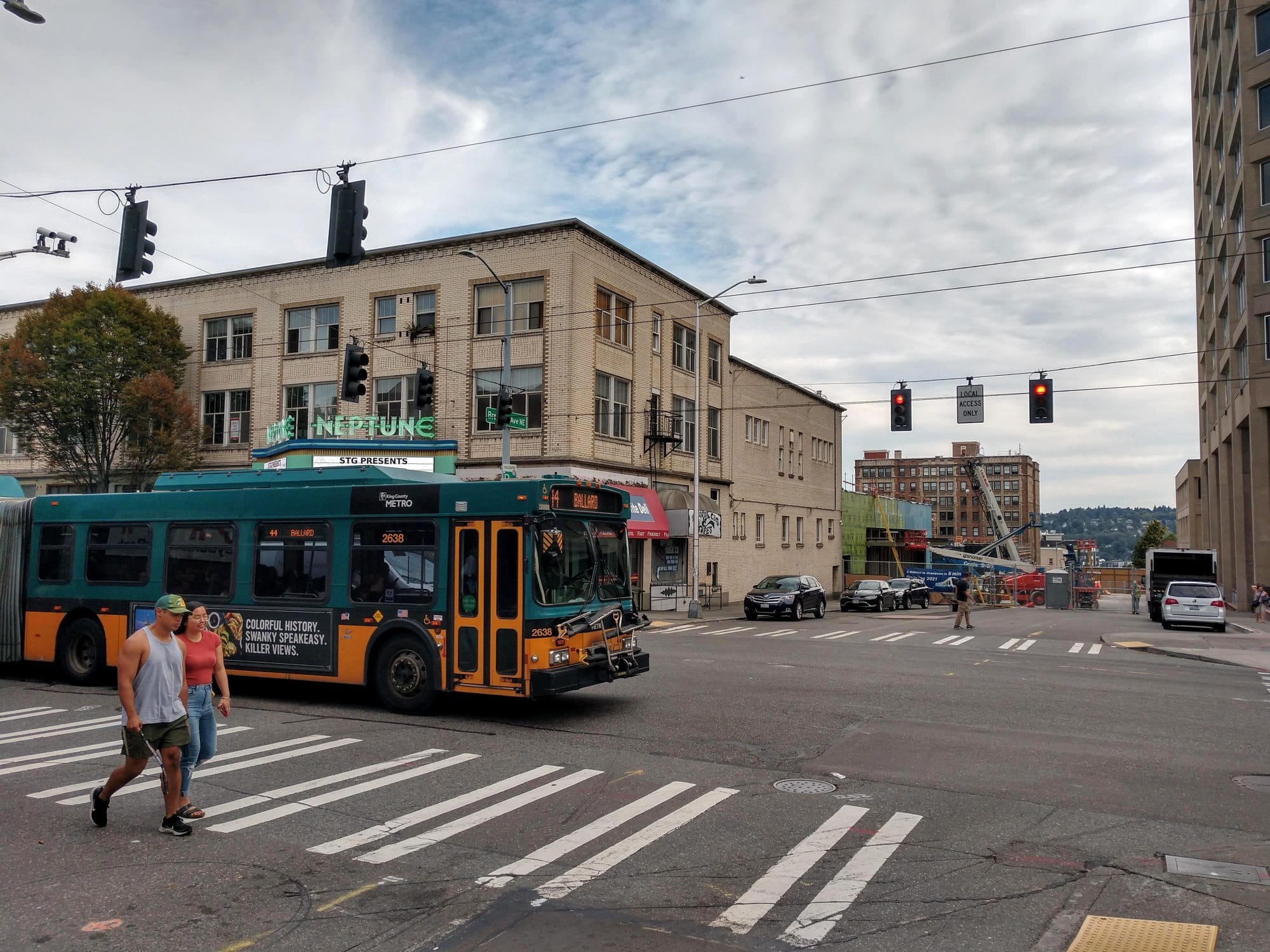
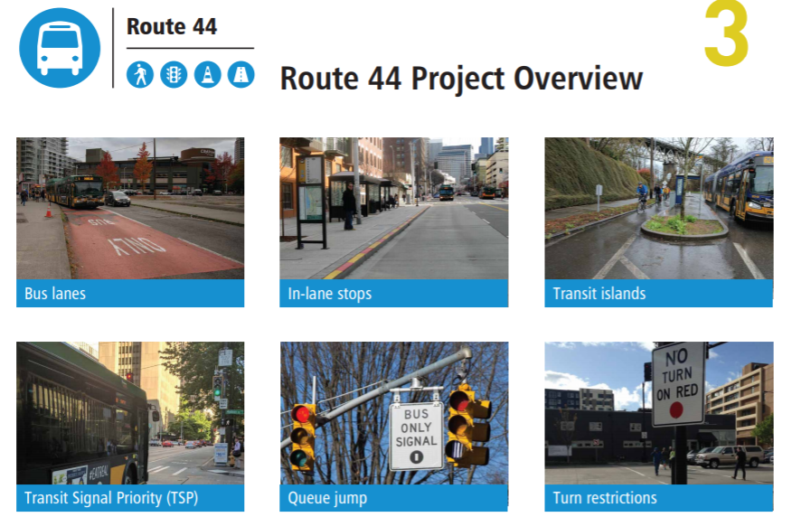
Route 44 is Seattle’s busiest crosstown bus and the Seattle Department of Transportation (SDOT) has a plan to roll out some bus lanes and safety improvements in 2023. How extensive those improvements are will depend on public pressure. SDOT is considering bus lanes near the troublesome intersections with 15th Avenue NW and SR-99.
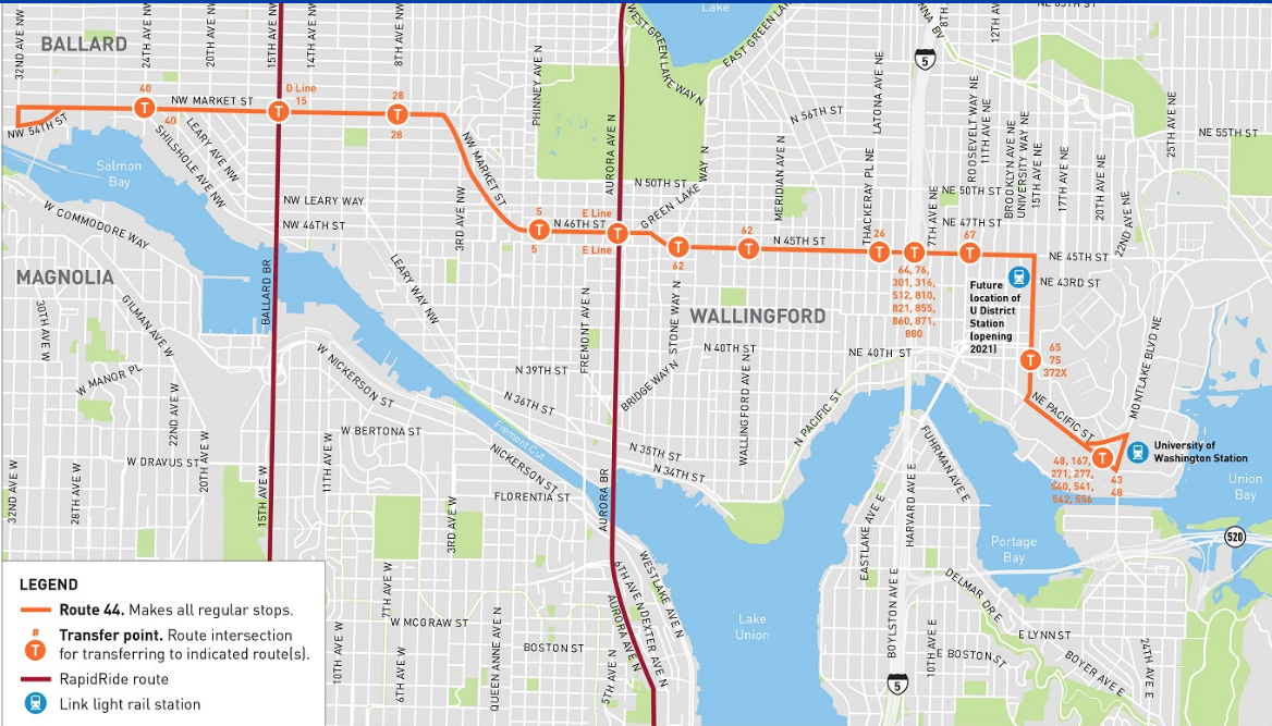
As a key 10.7-mile trolley corridor linking Ballard, Fremont, Wallingford, the U District and the University of Washington (UW) campus, the City estimates 35,000 live and 32,000 people work within a quarter-mile of the route. I covered SDOT’s outreach survey from November than gathered feedback and helped SDOT zero in on its initial advancing draft concepts (see display board for illustrations).
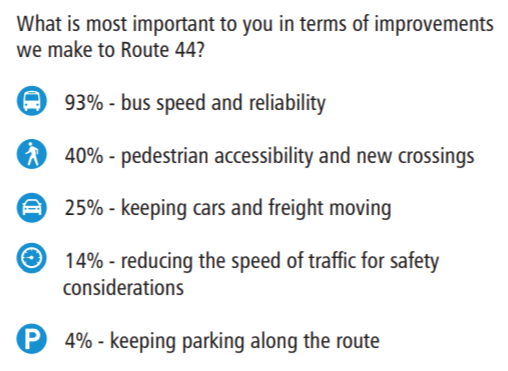
That survey found huge support for speeding up buses and making them more reliable. Among more than 800 respondents, 93% ranked “bus speed and reliability” as the most important priority, with “pedestrian accessibility and new crossings” coming in second at 40%. Keeping parking along the route was selected as a priority by only 4% of respondents.
Nonetheless, bus lane additions and parking removal through Wallingford has apparently been ruled out, which the Wallingford Community Council was happy to report.
U District Bus Lanes
SDOT also isn’t yet trumpeting significant changes to 15th Avenue NE in the U District, which is a major five-lane barrier separating UW campus from the U District. Last year, Move All Seattle Sustainably (MASS) coalition (of which The Urbanist is a member) called for bus lanes on 15th Avenue NE and NE 45th Street to improve reliability for the many bus routes that use the corridor while also calming traffic for the droves of pedestrians crossing it. Perhaps responding to that pressure, SDOT did quietly add 15th Avenue NE bus lanes (in the form of business access and transit or BAT lanes) to its advancing concepts.
It’s hard to imagine UW meeting the mode split goals set in its Campus Master Plan without bus lanes and more reliable transit service on 15th Avenue NE. And yet, the university hasn’t been leading the charge to add them as far as I can tell. The city council-approved campus master plan tasks UW with hitting 12% single-occupancy vehicle use by 2028–down from 19% today. That’s a lot of ground to cover in eight years.
What is proposed in one draft concept, however, is two and half blocks worth of eastbound bus lanes on NE 45th Street in front of U District Station, which opens next year. When it does, Brooklyn Avenue NE will become a busy transfer point between buses and trains, and the bus lane will do heavy work.
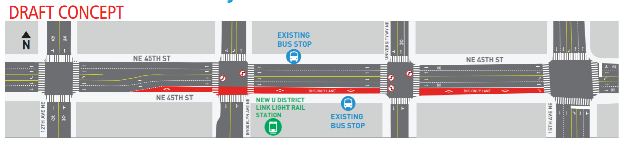
If I had a magic wand, I’d extend these bus lanes across I-5 as far as Latona Avenue N and add them westbound too. Then, along with 15th Avenue NE bus lanes, there’d be two miles of contiguous bus lanes for Route 44 riders rather than two blocks of red carpet treatment for eastbound riders before being unceremoniously dumped back into traffic. In contrast, SDOT proposes removing the bus stops at the I-5 interchange rather than extend bus lanes though this contested space.
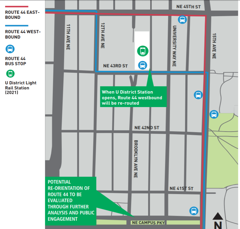
Instead, SDOT plans to divert westbound Route 44 from its existing route at 12th Avenue NE (a designated neighborhood greenway) and use NE 43rd Street in mixed traffic for six blocks. A diverging route could be confusing for riders, as survey respondents noted. This planned rerouting would go into effect as soon as U District Station opens in 2021. Earlier iterations of the U District Mobility plan had hoped to pedestrianize both NE 43rd Street and University Way NE (“The Ave”), but instead The Ave is staying as is and NE 43rd is becoming a major bus corridor.
Given the lack of pedestrianization happening in U District despite years of process pleading for it, pedestrianizing The Ave would take the sting out of this decision. Or maybe we could keep westbound Route 44 on NE 45th Street and add extensive bus lanes to keep it moving while properly pedestrianizing NE 43rd Street.
Closing Wallingford Avenue
SDOT did maybe shoot itself in the foot as the route heads into Wallingford since safety upgrades a few years back added bump outs and medians that prevent adding a bus lane without tearing up the street. This appears to be an area where the City’s transit master plan (which calls for N 45th Street bus lanes) and its pedestrian master plan are not in sync. Wallingford congestion is typically an issue, but it’s also crucial that pedestrian crossings are safe along this well-traveled business district.
To that effect, SDOT does propose one ambitious concept in Wallingford that would close a small section of Wallingford Avenue outside of QFC to make it easier for pedestrian to cross, reduce turning conflicts, and shorten signal phases to speed up transit.
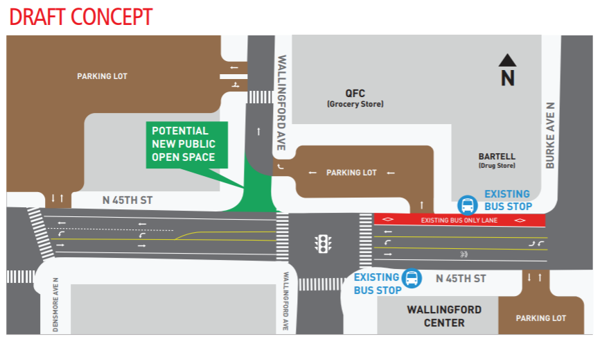
This would be a fairly dramatic change, but, as you can see in the diagram above, QFC’s front parking lot serves as a circulator allowing motorists access to the grocery store and its larger parking lot to the west if the front lot is full. Moreover, neighboring streets provide access to QFC and its big parking lot perhaps costing motorists an extra block or two of driving at most.
It would be a huge improvement for pedestrians who have a long wait to cross this awkward and busy signal. For transit, the change allows for shorter wait times as well since a whole turn phase would evaporate. This is key spot for transit signal priority and a queue jump that helps make up for the lack of bus lanes more broadly.
Existing westbound buses lanes do help east of Stone Way, before the next planned improvements near SR-99.
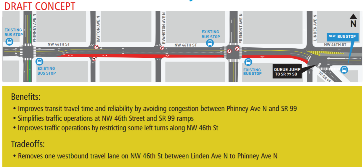
Fremont Bus Lane
First is a minor revision to the Green Lake Way N intersection, which is a disaster to cross for people walking, rolling, and biking. Closing Whitman Avenue N (save for a mountable curb for emergency vehicles) would allow pedestrians one less road to cross–albeit the quietest and narrowest. The long skewed crosswalk would then shift to east to cross perpendicularly if I’m catching SDOT’s drift. SDOT also proposes to add another lane to N 46th Street, although none of the five lanes here are proposed to be bus-only.
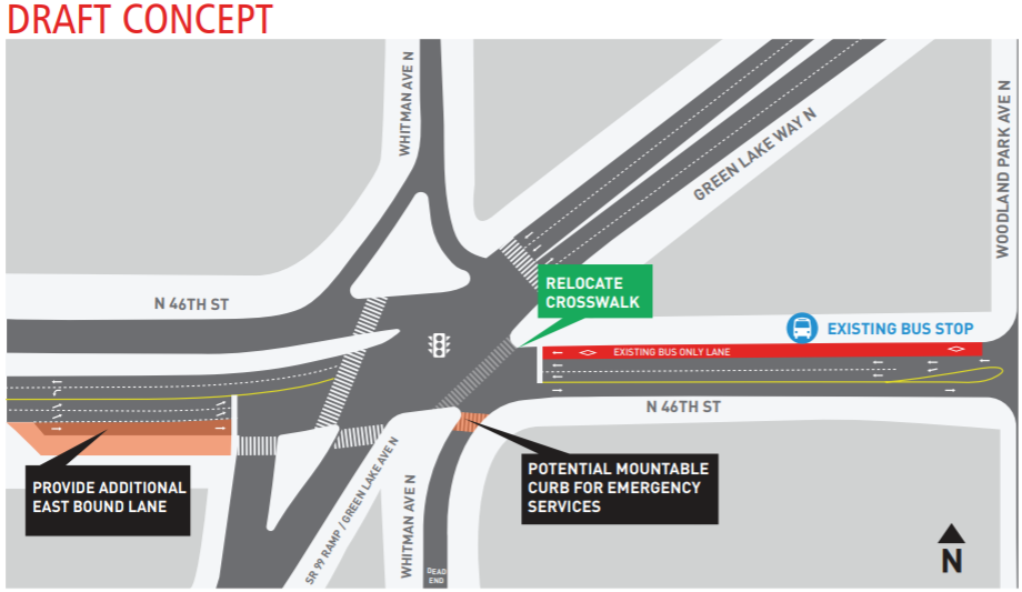
The bigger change comes on the west side of SR-99 where SDOT proposes a three-and-a-half block stretch of eastbound bus lanes (made possible by removing one of two westbound travel lanes). The eastbound bus stop just east of SR-99 would also be moved just west of it. This is a problem spot for congestion so this could be a consequential change.
Ballard Bus Lane
The fact that SDOT thinks only one general purpose lane is needed for westbound 46th Street suggests the same for whole corridor to Ballard. MASS proposed adding bus lanes from 3rd Avenue NW to 17th Avenue NW, where the extra travel lanes mainly encourage speeding and make it harder to cross the street.
SDOT took up part of this concept, suggesting an eastbound bus lane in Ballard from 20th Avenue NW to 15th Avenue NW. This would help buses get through this busy, often-clogged intersection, but westbound buses could use the help too.
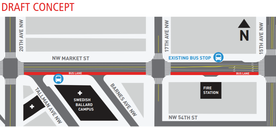
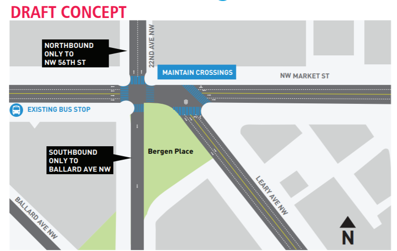
NW Market Street traffic can be heavy throughout Ballard, and more bus lanes aren’t being proposed, but one change at 22nd Avenue NW could help a little. The northbound travel lane on 22nd would be removed south of Market Street, shortening the crossing distance, while the north of Market, 22nd Avenue would be northbound only. This means the intersection would not need a crossing phase for 22nd Avenue since those movements wouldn’t be possible. As it stands now Leary Way NW and 22nd Avenue NW need separate phases since their movements conflict, which makes this light really long. This change would shorten that a bit.
All in all, these are some promising concepts from SDOT. Route 44 would operate more smoothly with these key sections of bus lanes, turn restrictions, and queue jumps. Already 9,300 daily riders rely on Route 44 to get them where they need to go. We can serve them a lot better and attract many more riders while we’re at it. The way the corridor is growing from Ballard to Stone Way to the U District we should certainly prepare for growth in ridership and pedestrian traffic.
Check out the project website for updates and more information and email SDOT’s communications and outreach lead Darrell Bulmer with comments at darrell.bulmer@seattle.gov.